1970s Maps of Springfield, Massachusetts
Explore 5 historic maps of Springfield from the 1970s. These maps offer a rare glimpse into what life looked like during the 1970s — showing old roads, neighborhoods, homes, and landmarks that have changed or disappeared over time.
Whether you're researching your family's past, planning a metal detecting trip, or studying how Springfield's landscape evolved across the 1970s, these high-resolution maps are a powerful tool for exploring the history of this region.
- Focus on a specific era: All maps on this page are from the 1970s, giving you a focused view of this time period.
- See what’s changed: Compare century-old streets, trails, and buildings to today's modern landscape using overlays and satellite layers.
- Research with precision: Use these maps for genealogy, historical research, land use analysis, or educational projects.
- View, download, or print: Maps are fully viewable online in high resolution, and can be downloaded or printed for your own records.
Start exploring Springfield's history through authentic maps from the 1970s. This is your window into the past.
Springfield, MA maps
(5)- 1972 Map of Springfield North, 1974 Print
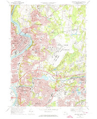 1972 Springfield North1974 Print · USGSGreater Springfield and the Pioneer Valley come into focus in the early 1970s, showing the intersection of river-powered industry and mid-century military growth. Researchers can trace historic cemeteries like Notre Dame Cemetery, local schools, and the massive footprint of Westover Air Force Base.3 unique versions available
 - 1975 Map of Ludlow, 1981 Print
 1975 Ludlow1981 Print · USGSHampden County's industrial and natural landscape is visible in this mid-seventies aerial survey. Trace the river-side growth of Ludlow and North Wilbraham or locate land tracts near Springfield Reservoir and Minechoag Mountain.
 - 1975 Map of Springfield South, 1981 Print
 1975 Springfield South1981 Print · USGSThe Pioneer Valley comes into sharp focus during the mid-1970s, showing the industrial and residential growth along the Connecticut River. Researchers can trace the mid-century footprints of Springfield, West Springfield, and Thompsonville through high-resolution aerial imagery.
 - 1975 Map of Springfield North, 1981 Print
 1975 Springfield North1981 Print · USGSMassachusetts’ Pioneer Valley appears in striking aerial detail during the mid-seventies, showing the industrial density of the Connecticut River towns. Trace the historic streetscapes of Holyoke and Chicopee or the rural-suburban edges of Scott Corners.
 - 1975 Map of Hampden, 1981 Print
 1975 Hampden1981 Print · USGSThe Massachusetts-Connecticut borderlands appear in sharp detail in the mid-1970s, showcasing the transition from valley to upland. Trace property lines and land use across the Wilbraham Mountains and through settlements like Baptist Village and Hampden.
End of results
Showing maps 1-5 of 5
Top cities near Springfield
- Chicopee historical maps
- Enfield historical maps
- Westfield historical maps
- Holyoke historical maps
- Amherst historical maps
- Windsor historical maps
See more
Top neighborhoods of Springfield
- Old Hill historical maps
- Brightwood historical maps
- East Forest Park historical maps
- Forest Park historical maps
- Liberty Heights historical maps
- East Springfield historical maps
See more
Frequently asked questions
- What are the different types of historical maps available for Springfield?
- What is the oldest map of Springfield?
- Where can I purchase historical maps of Springfield for my home or office?
- Where can I download high-res historical maps of Springfield?
- Are there historical topographic maps available for Springfield?
- Is there historical aerial imagery available for Springfield?
- Where are historical maps of Springfield sourced from?