1930s Maps of Springfield, Massachusetts
Explore 7 historic maps of Springfield from the 1930s. These maps offer a rare glimpse into what life looked like during the 1930s — showing old roads, neighborhoods, homes, and landmarks that have changed or disappeared over time.
Whether you're researching your family's past, planning a metal detecting trip, or studying how Springfield's landscape evolved across the 1930s, these high-resolution maps are a powerful tool for exploring the history of this region.
- Focus on a specific era: All maps on this page are from the 1930s, giving you a focused view of this time period.
- See what’s changed: Compare century-old streets, trails, and buildings to today's modern landscape using overlays and satellite layers.
- Research with precision: Use these maps for genealogy, historical research, land use analysis, or educational projects.
- View, download, or print: Maps are fully viewable online in high resolution, and can be downloaded or printed for your own records.
Start exploring Springfield's history through authentic maps from the 1930s. This is your window into the past.
Springfield, MA maps
(7)- 1933 Map of Chicopee
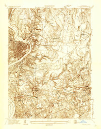 1933 Chicopee1933 Print · USGSThe industrial corridor of the Pioneer Valley is frozen in time during the early 1930s, showing the dense mill and residential centers along the river bends. Trace local family history through numerous landmarks like St Patrick Cem, the West Street Sch, and the grounds of the Springfield Airport.
 - 1933 Map of Longmeadow
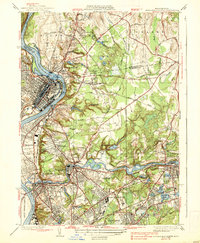
 1933 Longmeadow1933 Print · USGSThe Connecticut River valley thrives in the early 1930s as a hub of industry, education, and transport. Researchers can trace historic family plots at Springfield Cemetery or locate old rail hubs like Union Station and the Longmeadow Sta.
 - 1938 Map of Springfield North
 1938 Springfield North1938 Print · USGSThe industrial corridor of the Connecticut River comes alive in this pre-war survey, showcasing the canal-driven growth of Holyoke and Chicopee. Genealogists can trace family roots through sites like St Stanislaus Cem or the localized neighborhoods of Aldenville and South Hadley Falls.4 unique versions available
 - 1938 Map of Springfield South
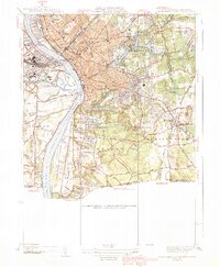
 1938 Springfield South1938 Print · USGSSpringfield and its southern neighbors appear here in the late 1930s, showing a bustling industrial city and its growing suburbs before postwar change. Researchers can trace historic rail lines through Union Sta or locate family plots in Oak Grove Cemetery and St Michaels Cemetery.3 unique versions available
 - 1939 Map of Hampden
 1939 Hampden1939 Print · USGSHampden and Wilbraham are captured here just before the mid-century expansion of the Springfield suburbs. Researchers can trace historic local sites like Wilbraham Academy, find family names at Prospect Hill Cem, and locate the small settlement of Baptist Village.
 - 1939 Map of Ludlow
 1939 Ludlow1939 Print · USGSThe industrial Chicopee River valley meets the rolling Facing Hills in this late 1930s survey of Hampden County. Local researchers can trace the rail-side growth of Ludlow, locate old burial grounds like Maplewood Cem, or find the campus of the Wilbraham Academy.
 - 1939 Map of Springfield South
 1939 Springfield South1939 Print · USGSThe Pioneer Valley hums with industrial and civic energy in the late thirties as rail hubs and river crossings define the landscape. Trace the urban layout of Springfield through landmarks like the U S Armory, Union Sta, and Oak Grove Cemetery.2 unique versions available
End of results
Showing maps 1-7 of 7
Top cities near Springfield
- Chicopee historical maps
- Enfield historical maps
- Westfield historical maps
- Holyoke historical maps
- Amherst historical maps
- Windsor historical maps
See more
Top neighborhoods of Springfield
- Old Hill historical maps
- Brightwood historical maps
- East Forest Park historical maps
- Forest Park historical maps
- Liberty Heights historical maps
- East Springfield historical maps
See more
Frequently asked questions
- What are the different types of historical maps available for Springfield?
- What is the oldest map of Springfield?
- Where can I purchase historical maps of Springfield for my home or office?
- Where can I download high-res historical maps of Springfield?
- Are there historical topographic maps available for Springfield?
- Is there historical aerial imagery available for Springfield?
- Where are historical maps of Springfield sourced from?