Old Maps of Springfield, Massachusetts for Hiking & Exploration
Hike through history with 69 historic maps of Springfield. Explore old trails, ghost towns, and forgotten backroads — perfect for outdoor adventurers and local explorers.
- Rediscover forgotten places: Map out old mining camps, roads, and footpaths that no longer exist on modern maps.
- Layer with modern tools: Combine with LiDAR or satellite views to plan hikes through historical terrain.
- Made for exploration: Popular among hikers, overlanders, and local history lovers.
Use these maps to find adventure and explore the hidden past of Springfield.
Springfield, MA maps
(69)- 1886 Map of Springfield
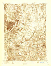
 1886 Springfield1886 Print · USGSThe Connecticut River valley thrives as a rail and industrial powerhouse at the end of the nineteenth century. Genealogists and researchers can trace local families and industry in hubs like Chicopee Falls, Ireland Parish, and the growing streetscapes of Brightwood.
 - 1887 Map of Palmer
 1887 Palmer1887 Print · USGSHampden County's industrial river valleys thrive in the late nineteenth century as rail and water power converge. Genealogists and historians can trace the growth of Three Rivers, locate the Alms House near Palmer, and identify old mill sites like Ellis Mills.
 - 1889 Map of Springfield
 1889 Springfield1889 Print · USGSThe Connecticut River valley thrives as an industrial powerhouse in the 1880s, fueled by a dense network of water power and rail. Genealogists and historians can trace the foundations of Holyoke and Springfield, or find smaller settlements like Baptist Village and Mittineague.
 - 1889 Map of Palmer
 1889 Palmer1889 Print · USGSHampden County and the surrounding valley are shown here in the 1880s as a thriving hub of rail and water-powered industry. Genealogists and historians can trace the foundations of local commerce through landmarks like Ellis Mills, the State Alms House, and the Granite Quarry.
 - 1893 Map of Springfield
 1893 Springfield1893 Print · USGSThe Pioneer Valley at the end of the nineteenth century centers on the bustling riverfronts of Springfield and Holyoke. Genealogists and historians can trace the rail-connected neighborhoods of Indian Orchard, the distinct Shakers settlement, and early industries along the Chicopee River.
 - 1893 Map of Palmer
 1893 Palmer1893 Print · USGSHampden County and its surrounding borders are captured here during a peak era of rail expansion and water-powered industry. Researchers can trace the junction of major lines at Barretts Junction or locate vanished industrial hamlets like Duckville and Ellis Mills.9 unique versions available
 - 1895 Map of Springfield
 1895 Springfield1895 Print · USGSThe Connecticut River valley thrives in the late 1800s as a powerhouse of rail-side industry and varied agricultural settlements. Researchers can trace the early layouts of Ireland Parish, the Shaker community, and the mills of Chicopee Falls.11 unique versions available
 - 1896 Map of Holyoke
 1896 Holyoke1896 Print · USGSThe Pioneer Valley and the eastern Berkshire foothills thrive in the 1890s as a complex network of industrial towns and upland farming communities. Historians can trace early infrastructure through the Bisbee Mill, the Agricultural College, and the prominent Ox Bow on the Connecticut River.
 - 1897 Map of Holyoke
 1897 Holyoke1897 Print · USGSThe Pioneer Valley and surrounding highlands thrive in the 1890s, caught here at the height of the region's industrial and agricultural development. Genealogists and historians can trace family roots through dozens of hill towns and river settlements, from Agricultural College in Amherst to the mills of Holyoke and the remote tracks of the Athol Br. R. R..
 - 1901 Map of Holyoke
 1901 Holyoke1901 Print · USGSThe Pioneer Valley and surrounding highlands thrive at the turn of the century, showing a landscape defined by mill towns and early rail networks. Genealogists and historians can trace old homesteads and local landmarks like Bisbee Mill, South Ferry, and the Agricultural College.4 unique versions available
 - 1908 Map of Ware
 1908 Ware1908 Print · USGSCentral Massachusetts at the turn of the century reveals the Swift River Valley decades before the Quabbin Reservoir changed the landscape forever. Trace the lost footprints of Enfield and Dana, or follow the Central Vermont RR through Greenwich Village and Ware.2 unique versions available
 - 1919 Map of Palmer
 1919 Palmer1919 Print · USGSHampden County and the Connecticut borderlands are captured here during the height of the steam-rail era. Genealogists and historians can trace the foundations of local industry at Fosketts Mill, the Granite Quarry, and the sprawling Monson State Hospital.
 - 1920 Map of Springfield
 1920 Springfield1920 Print · USGSGreater Springfield and the Pioneer Valley are captured here during a period of intense industrial and rail expansion. Genealogists and local historians can trace the foundations of neighborhoods like Indian Orchard, locate the Shaker Sta, or study the early rail alignments of the Boston and Albany RR.
 - 1928 Map of Long Meadow
 1928 Long Meadow1928 Print · USGSNorth-central Connecticut and the Massachusetts border are captured here in the late twenties, showing the region's transition into the modern era. Genealogists can trace the rail-and-river network through Thompsonville and find the site of Shaker Sta.
 - 1933 Map of Chicopee
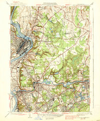
 1933 Chicopee1933 Print · USGSThe industrial corridor of the Pioneer Valley is frozen in time during the early 1930s, showing the dense mill and residential centers along the river bends. Trace local family history through numerous landmarks like St Patrick Cem, the West Street Sch, and the grounds of the Springfield Airport.
 - 1933 Map of Longmeadow
 1933 Longmeadow1933 Print · USGSThe Connecticut River valley thrives in the early 1930s as a hub of industry, education, and transport. Researchers can trace historic family plots at Springfield Cemetery or locate old rail hubs like Union Station and the Longmeadow Sta.
 - 1938 Map of Springfield North
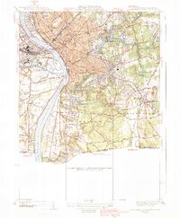
 1938 Springfield North1938 Print · USGSThe industrial corridor of the Connecticut River comes alive in this pre-war survey, showcasing the canal-driven growth of Holyoke and Chicopee. Genealogists can trace family roots through sites like St Stanislaus Cem or the localized neighborhoods of Aldenville and South Hadley Falls.4 unique versions available
 - 1938 Map of Springfield South
 1938 Springfield South1938 Print · USGSSpringfield and its southern neighbors appear here in the late 1930s, showing a bustling industrial city and its growing suburbs before postwar change. Researchers can trace historic rail lines through Union Sta or locate family plots in Oak Grove Cemetery and St Michaels Cemetery.3 unique versions available
 - 1939 Map of Hampden
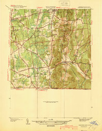
 1939 Hampden1939 Print · USGSHampden and Wilbraham are captured here just before the mid-century expansion of the Springfield suburbs. Researchers can trace historic local sites like Wilbraham Academy, find family names at Prospect Hill Cem, and locate the small settlement of Baptist Village.
 - 1939 Map of Ludlow
 1939 Ludlow1939 Print · USGSThe industrial Chicopee River valley meets the rolling Facing Hills in this late 1930s survey of Hampden County. Local researchers can trace the rail-side growth of Ludlow, locate old burial grounds like Maplewood Cem, or find the campus of the Wilbraham Academy.
 - 1939 Map of Springfield South
 1939 Springfield South1939 Print · USGSThe Pioneer Valley hums with industrial and civic energy in the late thirties as rail hubs and river crossings define the landscape. Trace the urban layout of Springfield through landmarks like the U S Armory, Union Sta, and Oak Grove Cemetery.2 unique versions available
 - 1940 Map of Hampden
 1940 Hampden1940 Print · USGSMassachusetts and Connecticut borderlands meet at the edge of the Berkshires in the late thirties. Local historians can trace old homesteads and community hubs near Baptist Village, Woodland Dell Cem, and the high peak of Minnechoag Mountain.2 unique versions available
 - 1942 Map of Ludlow
 1942 Ludlow1942 Print · USGSHampden County landscapes in the late thirties reveal a mix of industrial river towns and upland reservoirs. Genealogists can trace family footprints through the Wilbraham Academy, East Wilbraham Cem, and the neighborhoods around Indian Orchard.
 - 1942 Map of Hampden
 1942 Hampden1942 Print · USGSThe Pioneer Valley foothills are captured here in the years before the war, showing the rural character of Hampden and Wilbraham. Genealogists and historians can locate family-named sites such as Adams Cem, Baptist Village, and the Stony Hill Sch.
 - 1942 Map of Ware
 1942 Ware1942 Print · USGSCentral Massachusetts and the Connecticut border are captured here during the early years of the war, just as the landscape was being reshaped by the Quabbin Reservoir. Researchers can trace rail-era industry and local landmarks like the Lead Mine and the Bald Peak Hospital.
Showing maps 1-25 of 69
Top cities near Springfield
- Chicopee historical maps
- Enfield historical maps
- Westfield historical maps
- Holyoke historical maps
- Amherst historical maps
- Windsor historical maps
See more
Top neighborhoods of Springfield
- Old Hill historical maps
- Brightwood historical maps
- East Forest Park historical maps
- Forest Park historical maps
- Liberty Heights historical maps
- East Springfield historical maps
See more
Frequently asked questions
- What are the different types of historical maps available for Springfield?
- What is the oldest map of Springfield?
- Where can I purchase historical maps of Springfield for my home or office?
- Where can I download high-res historical maps of Springfield?
- Are there historical topographic maps available for Springfield?
- Is there historical aerial imagery available for Springfield?
- Where are historical maps of Springfield sourced from?