1950s Maps of Groton, Massachusetts
Explore 9 historic maps of Groton from the 1950s. These maps offer a rare glimpse into what life looked like during the 1950s — showing old roads, neighborhoods, homes, and landmarks that have changed or disappeared over time.
Whether you're researching your family's past, planning a metal detecting trip, or studying how Groton's landscape evolved across the 1950s, these high-resolution maps are a powerful tool for exploring the history of this region.
- Focus on a specific era: All maps on this page are from the 1950s, giving you a focused view of this time period.
- See what’s changed: Compare century-old streets, trails, and buildings to today's modern landscape using overlays and satellite layers.
- Research with precision: Use these maps for genealogy, historical research, land use analysis, or educational projects.
- View, download, or print: Maps are fully viewable online in high resolution, and can be downloaded or printed for your own records.
Start exploring Groton's history through authentic maps from the 1950s. This is your window into the past.
Groton, MA maps
(9)- 1950 Map of Townsend, 1952 Print
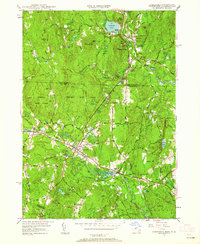 1950 Townsend1952 Print · USGSMid-century Middlesex County and southern New Hampshire centers on the rail-and-river corridor of Townsend. Genealogists and historians can trace the Boston and Maine Railroad through Townsend Harbor and locate family sites like Hillside Cem and Barker Hill.2 unique versions available
 - 1950 Map of Pepperell, 1952 Print
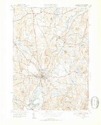 1950 Pepperell1952 Print · USGSThe borderlands of Massachusetts and New Hampshire are captured here at mid-century, centered on the river junctions and rail lines of the Nashua valley. Genealogists and local historians can trace the Boston and Maine tracks to the Hollis Depot or locate family plots at St Joseph Cem and Woodlawn Cem.4 unique versions available
 - 1950 Map of Westford, 1952 Print
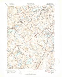 1950 Westford1952 Print · USGSMiddlesex County in the early fifties shows a region defined by its rail heritage and historic village centers. Trace old family lines through Graniteville, Forge Village, and Littleton Common, or locate ancestral burial sites at Russian Cem and Nutting Cem.4 unique versions available
 - 1950 Map of Tyngsboro, 1952 Print
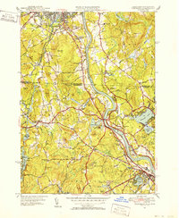 1950 Tyngsboro1952 Print · USGSThe Merrimack River valley at the mid-century mark reveals a landscape of growing towns and academic centers along the New Hampshire border. Researchers can trace old family sites like Frederick Corner, locate the Flat Rock Quarry, or find the Old Dunstable Cem.3 unique versions available
 - 1950 Map of Shirley, 1958 Print
 1950 Shirley1958 Print · USGSMid-century development spreads through the Worcester and Middlesex county lines during this era of growth. Genealogists and local historians can trace family plots in St Cecelia Cemetery or locate old school sites like the White Sch and the Industrial School.
 - 1950 Map of Ayer, 1958 Print
 1950 Ayer1958 Print · USGSMiddlesex and Worcester counties are shown here at mid-century, highlighting the massive expansion of the Fort Devens military footprint. Researchers can trace the layout of Shaker Village, find the Harvard University Observatory, and locate the Groton School.
 - 1955 Map of Shirley
 1955 Shirley1955 Print · USGSCentral Massachusetts at mid-century shows the significant expansion of military life and rail transit near the Nashua River. Trace local family roots at St Leo Cem or explore the extensive footprint of Fort Devens Military Reservation and the Boston and Maine Railroad.2 unique versions available
 - 1956 Map of Boston, 1967 Print
 1956 Boston1967 Print · USGSThe Massachusetts coastline and industrial interior are seen here during the mid-century peak of suburban and highway expansion. Researchers can trace historic harbor defenses like Fort Revere, local landmarks such as Faneuil Hall, and the vast Parker River National Wildlife Refuge.6 unique versions available
 - 1958 Map of Boston
 1958 Boston1958 Print · USGSEastern Massachusetts and southern New Hampshire are shown at the height of the industrial era, before the full expansion of the interstate system. Trace coastal defenses at Fort Warren, historic rail lines like the Boston and Maine, and the development of the Mass. 128 corridor.2 unique versions available
End of results
Showing maps 1-9 of 9
Top cities near Groton
- Lowell historical maps
- Nashua historical maps
- Leominster historical maps
- Fitchburg historical maps
- Chelmsford historical maps
- Dracut historical maps
See more
Top neighborhoods of Groton
Frequently asked questions
- What are the different types of historical maps available for Groton?
- What is the oldest map of Groton?
- Where can I purchase historical maps of Groton for my home or office?
- Where can I download high-res historical maps of Groton?
- Are there historical topographic maps available for Groton?
- Is there historical aerial imagery available for Groton?
- Where are historical maps of Groton sourced from?