1970s Maps of Woburn, Massachusetts
Explore 6 historic maps of Woburn from the 1970s. These maps offer a rare glimpse into what life looked like during the 1970s — showing old roads, neighborhoods, homes, and landmarks that have changed or disappeared over time.
Whether you're researching your family's past, planning a metal detecting trip, or studying how Woburn's landscape evolved across the 1970s, these high-resolution maps are a powerful tool for exploring the history of this region.
- Focus on a specific era: All maps on this page are from the 1970s, giving you a focused view of this time period.
- See what’s changed: Compare century-old streets, trails, and buildings to today's modern landscape using overlays and satellite layers.
- Research with precision: Use these maps for genealogy, historical research, land use analysis, or educational projects.
- View, download, or print: Maps are fully viewable online in high resolution, and can be downloaded or printed for your own records.
Start exploring Woburn's history through authentic maps from the 1970s. This is your window into the past.
Woburn, MA maps
(6)- 1971 Map of Boston North, 1973 Print
 1971 Boston North1973 Print · USGSThe northern reaches of the Massachusetts capital show a landscape of dense suburbs and protected woodlands in the early seventies. Researchers can locate landmark sites like the Bunker Hill Monument, trace the MBTA System rail lines, or explore the grounds of Harvard University and Holy Cross Cemetery.2 unique versions available
 - 1971 Map of Lexington, 1973 Print
 1971 Lexington1973 Print · USGSThe suburban landscape of Middlesex County is shown here in the early 1970s as historic town centers integrated with major institutional and commercial developments. Genealogists and historians can locate dozens of neighborhood schools, local churches, and expansive grounds such as Mc Lean Hospital and St Patricks Cem.2 unique versions available
 - 1977 Map of Boston North, 1980 Print
 1977 Boston North1980 Print · USGSThe northern suburbs of Boston come into focus in the late 1970s through this detailed orthophotoquad survey. Trace the urban landscape from the Mystic River waterfront to the dense neighborhoods of Malden, Everett, and Revere.
 - 1977 Map of Lexington, 1980 Print
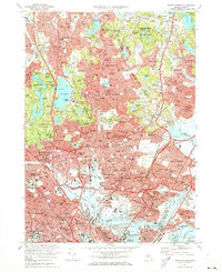
 1977 Lexington1980 Print · USGSSuburban Middlesex County comes into sharp focus in the late seventies as residential growth fills the spaces between historic township centers. Researchers can trace the mid-century street patterns of Lexington, Arlington, and Waltham or follow the course of the Aberjona River.
 - 1977 Map of Reading, 1980 Print
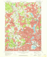
 1977 Reading1980 Print · USGSNortheastern Massachusetts towns show their modern footprints in the late seventies as residential growth surrounds traditional river corridors. Trace the development of North Reading, Peabody, and Reading along the Ipswich River.
 - 1977 Map of Wilmington, 1980 Print
 1977 Wilmington1980 Print · USGSWilmington and its Middlesex County neighbors are shown during the suburban surge of the late seventies. Researchers can trace the development of residential neighborhoods in Burlington and Pinehurst or locate landmarks near Silver Lake.
End of results
Showing maps 1-6 of 6
Top cities near Woburn
- Boston historical maps
- Lowell historical maps
- Cambridge historical maps
- Quincy historical maps
- Lynn historical maps
- Newton historical maps
See more
Top neighborhoods of Woburn
- Montvale historical maps
- Mishawum historical maps
- North Woburn historical maps
- Woburn Highlands historical maps
- Central Square historical maps
- Cummingsville historical maps
See more
Frequently asked questions
- What are the different types of historical maps available for Woburn?
- What is the oldest map of Woburn?
- Where can I purchase historical maps of Woburn for my home or office?
- Where can I download high-res historical maps of Woburn?
- Are there historical topographic maps available for Woburn?
- Is there historical aerial imagery available for Woburn?
- Where are historical maps of Woburn sourced from?