1950s Maps of Woburn, Massachusetts
Explore 6 historic maps of Woburn from the 1950s. These maps offer a rare glimpse into what life looked like during the 1950s — showing old roads, neighborhoods, homes, and landmarks that have changed or disappeared over time.
Whether you're researching your family's past, planning a metal detecting trip, or studying how Woburn's landscape evolved across the 1950s, these high-resolution maps are a powerful tool for exploring the history of this region.
- Focus on a specific era: All maps on this page are from the 1950s, giving you a focused view of this time period.
- See what’s changed: Compare century-old streets, trails, and buildings to today's modern landscape using overlays and satellite layers.
- Research with precision: Use these maps for genealogy, historical research, land use analysis, or educational projects.
- View, download, or print: Maps are fully viewable online in high resolution, and can be downloaded or printed for your own records.
Start exploring Woburn's history through authentic maps from the 1950s. This is your window into the past.
Woburn, MA maps
(6)- 1950 Map of Wilmington, 1952 Print
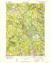 1950 Wilmington1952 Print · USGSWilmington and Tewksbury are shown during a period of significant mid-century growth along the Boston and Maine rail lines. Researchers can trace the sprawling grounds of the State Infirmary and locate vanished local landmarks like the Whitefield Sch and Silver Lake.4 unique versions available
 - 1951 Map of Reading, 1952 Print
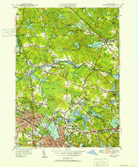 1951 Reading1952 Print · USGSNorth of Boston in the early fifties, the landscape around Reading and Wakefield shows a mix of growing residential centers and military training grounds. You can trace family roots at Lakeside Cem, locate the old Bachelder Sch, or explore the grounds of Camp Curtis Guild.3 unique versions available
 - 1956 Map of Lexington
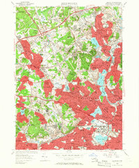 1956 Lexington1956 Print · USGSMiddlesex County was rapidly evolving in the mid-1950s as suburban residential belts thickened between established town centers. Genealogists and historians can trace institutional history at Metropolitan State Hospital or locate ancestral sites like the Old Burying Ground and St Patricks Cem.3 unique versions available
 - 1956 Map of Boston North, 1958 Print
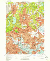 1956 Boston North1958 Print · USGSThe industrial and residential landscape north of Boston comes alive in the mid-fifties, from the shipyards to the suburban fells. Local historians can trace the extensive rail lines of the B & M Yards and landmark sites like the Bunker Hill Monument and Saugus Race Track.3 unique versions available
 - 1956 Map of Boston, 1967 Print
 1956 Boston1967 Print · USGSThe Massachusetts coastline and industrial interior are seen here during the mid-century peak of suburban and highway expansion. Researchers can trace historic harbor defenses like Fort Revere, local landmarks such as Faneuil Hall, and the vast Parker River National Wildlife Refuge.6 unique versions available
 - 1958 Map of Boston
 1958 Boston1958 Print · USGSEastern Massachusetts and southern New Hampshire are shown at the height of the industrial era, before the full expansion of the interstate system. Trace coastal defenses at Fort Warren, historic rail lines like the Boston and Maine, and the development of the Mass. 128 corridor.2 unique versions available
End of results
Showing maps 1-6 of 6
Top cities near Woburn
- Boston historical maps
- Lowell historical maps
- Cambridge historical maps
- Quincy historical maps
- Lynn historical maps
- Newton historical maps
See more
Top neighborhoods of Woburn
- Montvale historical maps
- Mishawum historical maps
- North Woburn historical maps
- Woburn Highlands historical maps
- Central Square historical maps
- Cummingsville historical maps
See more
Frequently asked questions
- What are the different types of historical maps available for Woburn?
- What is the oldest map of Woburn?
- Where can I purchase historical maps of Woburn for my home or office?
- Where can I download high-res historical maps of Woburn?
- Are there historical topographic maps available for Woburn?
- Is there historical aerial imagery available for Woburn?
- Where are historical maps of Woburn sourced from?