1970s Maps of Abington, Massachusetts
Explore 7 historic maps of Abington from the 1970s. These maps offer a rare glimpse into what life looked like during the 1970s — showing old roads, neighborhoods, homes, and landmarks that have changed or disappeared over time.
Whether you're researching your family's past, planning a metal detecting trip, or studying how Abington's landscape evolved across the 1970s, these high-resolution maps are a powerful tool for exploring the history of this region.
- Focus on a specific era: All maps on this page are from the 1970s, giving you a focused view of this time period.
- See what’s changed: Compare century-old streets, trails, and buildings to today's modern landscape using overlays and satellite layers.
- Research with precision: Use these maps for genealogy, historical research, land use analysis, or educational projects.
- View, download, or print: Maps are fully viewable online in high resolution, and can be downloaded or printed for your own records.
Start exploring Abington's history through authentic maps from the 1970s. This is your window into the past.
Abington, MA maps
(7)- 1971 Map of Blue Hills, 1972 Print
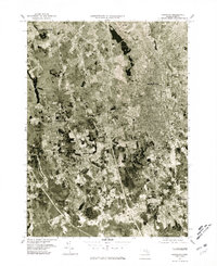
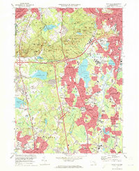 1971 Blue Hills1972 Print · USGSGreater Boston's southern suburbs and the forested Blue Hills are captured here during the early seventies' era of suburban expansion. Trace local family history at Blue Hill Cemetery or Holy Sepulchre Cem, and locate long-standing institutions like Curry College and Thayer Academy.2 unique versions available
 - 1971 Map of Weymouth, 1973 Print
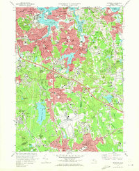 1971 Weymouth1973 Print · USGSThe Norfolk County coastline and its industrial suburbs are captured here in the early seventies, showing a period of high military and maritime activity. Genealogists and local historians can trace the grounds of the South Weymouth Naval Air Station or locate family plots in Fairmount Cemetery and Old North Cem.2 unique versions available
 - 1975 Map of Brockton, 1977 Print
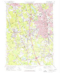 1975 Brockton1977 Print · USGSThe city of Brockton and surrounding towns are shown in the mid-seventies just as the modern highway system was fully integrating with old village centers. Researchers can trace historic institutions and local landmarks like Stonehill College, Stoughton Junction, and the Hockomock Swamp.2 unique versions available
 - 1977 Map of Whitman, 1978 Print
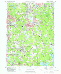 1977 Whitman1978 Print · USGSPlymouth County in the late seventies is a landscape of established rail corridors and industrial waterworks. Researchers can trace family sites near St Patricks Cemetery, Massasoit College, or the extensive Cranberry Bogs bordering Hanson.4 unique versions available
 - 1977 Map of Weymouth, 1980 Print
 1977 Weymouth1980 Print · USGSThe South Shore landscape comes into sharp focus in the late seventies through this detailed aerial orthophoto. Trace the residential growth of Weymouth and Braintree, or study the coastal inlets of the Weymouth Fore River.
 - 1977 Map of Blue Hills, 1980 Print
 1977 Blue Hills1980 Print · USGSSouth of the city in the late seventies, this aerial survey captures the evolving suburban landscape between the Blue Hills Range and Stoughton. Researchers can trace the development of residential neighborhoods and highway corridors in Randolph, Quincy, and Braintree.
 - 1977 Map of Brockton, 1981 Print
 1977 Brockton1981 Print · USGSBrockton and the surrounding Plymouth County townships appear in this detailed photographic study from the late seventies. Researchers can trace the exact 1977 footprints of settlements like Five Corners, North Easton, and West Bridgewater.
End of results
Showing maps 1-7 of 7
Top cities near Abington
- Boston historical maps
- Brockton historical maps
- Quincy historical maps
- Newton historical maps
- Brookline historical maps
- Plymouth historical maps
See more
Top neighborhoods of Abington
Frequently asked questions
- What are the different types of historical maps available for Abington?
- What is the oldest map of Abington?
- Where can I purchase historical maps of Abington for my home or office?
- Where can I download high-res historical maps of Abington?
- Are there historical topographic maps available for Abington?
- Is there historical aerial imagery available for Abington?
- Where are historical maps of Abington sourced from?