Old Maps of Ferry Hill, Marshfield for Academic Research
Study the evolution of Ferry Hill with 21 high-resolution historic maps. Whether you're teaching, researching, or modeling changes in land use, these maps provide essential visual documentation of urban, environmental, and geographic change.
- Analyze long-term change: Track patterns in development, transportation, and natural features.
- Ideal for environmental or urban studies: Support academic projects with primary historical map data.
- Use in the classroom or lab: Educators and researchers rely on these maps to bring historical context to life.
These maps are a powerful tool for teaching, research, and visualizing how Ferry Hill has changed over the decades.
Ferry Hill, Marshfield maps
(21)- 1885 Map of Duxbury
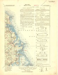
 1885 Duxbury1885 Print · USGSThe South Shore's coastal villages and early rail lines are meticulously documented here in the late nineteenth century. Genealogists and historians can trace the Old Colony Railroad stops at Duxbury Station or locate landmarks like the Standish Monument and Gurnet Lights.
 - 1888 Map of Duxbury
 1888 Duxbury1888 Print · USGSCoastal Plymouth County in the late 1880s shows a landscape of salt marshes and rail-connected villages. Genealogists can locate family homes near the Old Colony Railroad or trace historical landmarks like the Standish Monument and Gurnet Point.
 - 1893 Map of Duxbury
 1893 Duxbury1893 Print · USGSThe South Shore's maritime and rail landscape is captured here in the late 1800s, showing a coastline defined by salt marshes and ocean industry. Trace the Old Colony Railroad through Marshfield or locate the transatlantic Telegraph Cable to Brest.7 unique versions available
 - 1918 Map of Duxbury
 1918 Duxbury1918 Print · USGSThe Plymouth County coast is captured during the Great War era in this detailed military study of its shorelines and rail hubs. Trace maritime landmarks like Gurnet Lights and the Old Tower, or find local industrial history at the Saw Mill and Furnace.2 unique versions available
 - 1935 Map of Scituate
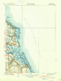
 1935 Scituate1935 Print · USGSCoastal Plymouth County is captured here in the mid-1930s, showing a landscape of tidal marshes and maritime hubs. Genealogists can trace the rail-era footprint of Scituate Sta and Marshfield Hills Sta or locate coastal landmarks like Scituate Lighthouse.
 - 1940 Map of Scituate
 1940 Scituate1940 Print · USGSThe Plymouth County coast is captured in the late 1930s, documenting a landscape of seaside villages and tidal rivers. Researchers can trace the path of the New York New Haven and Hartford RR and find local landmarks like Union Cem and Fourth Cliff.4 unique versions available
 - 1947 Map of Scituate, 1958 Print
 1947 Scituate1958 Print · USGSCoastal Plymouth County in the late 1940s reveals a landscape of tidal marshes and seaside villages. Genealogists and historians can trace the early layout of Scituate Harbor, the New York New Haven and Hartford rail line, and local landmarks like Union Cem.
 - 1948 Map of Boston
 1948 Boston1948 Print · USGSEastern Massachusetts and southern New Hampshire appear at an industrial peak in the late 1940s, just as suburban growth began to accelerate. Genealogists and historians can trace rail lines like the Boston and Albany RR or locate coastal landmarks like Graves Lighthouse and Fort Devens.2 unique versions available
 - 1956 Map of Boston, 1967 Print
 1956 Boston1967 Print · USGSThe Massachusetts coastline and industrial interior are seen here during the mid-century peak of suburban and highway expansion. Researchers can trace historic harbor defenses like Fort Revere, local landmarks such as Faneuil Hall, and the vast Parker River National Wildlife Refuge.6 unique versions available
 - 1958 Map of Boston
 1958 Boston1958 Print · USGSEastern Massachusetts and southern New Hampshire are shown at the height of the industrial era, before the full expansion of the interstate system. Trace coastal defenses at Fort Warren, historic rail lines like the Boston and Maine, and the development of the Mass. 128 corridor.2 unique versions available
 - 1961 Map of Boston
 1961 Boston1961 Print · USGSThe Massachusetts coastline and its industrial interior are detailed here in the mid-twentieth century, from the Monadnock highlands to Cape Cod. Researchers can trace the rail routes of the Boston and Maine or locate landmarks like Fort Devens and the Wachusett Reservoir.2 unique versions available
 - 1961 Map of Scituate, 1963 Print
 1961 Scituate1963 Print · USGSThe Plymouth County coast in the early sixties reveals a transition from traditional maritime villages to expanding shoreline communities. Trace local history through the Coast Guard Station, the Meeting House Lane Cemetery and Church, and the Scituate Station rail stop.2 unique versions available
 - 1974 Map of Scituate, 1976 Print
 1974 Scituate1976 Print · USGSThe South Shore of Massachusetts in the mid-seventies reveals a mix of coastal resort life and deep-seated maritime history. Genealogists and historians can trace family plots at Union Cem, locate the old Railroad Grade near Greenbush, or study the shoreline at Peggotty Beach.3 unique versions available
 - 1977 Map of Scituate, 1981 Print
 1977 Scituate1981 Print · USGSThe South Shore's tidal estuaries and coastal neighborhoods are captured in this late 1970s aerial survey. Trace the winding paths of the North River and South River as they meet at Humarock and the harbor at Scituate.
 - 1984 Map of Scituate
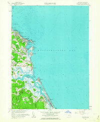
 1984 Scituate1984 Print · USGSCoastal Plymouth County in the mid-eighties shows a landscape of storied sea cliffs and winding tidal marshes. Genealogists and local historians can trace family roots through Meeting House Lane Cem, locate the Scituate Station, or explore the heritage of Scituate Harbor.2 unique versions available
 - 1984 Map of Provincetown, 1986 Print
 1984 Provincetown1986 Print · USGSThe Massachusetts coastline and the tip of Cape Cod appear here during the mid-eighties, highlighting the region's dense coastal settlements and maritime defenses. You can locate family landmarks in Marshfield, trace the grounds of the North Truro Air Force Station, and explore the islands of Boston Harbor like Peddocks Island.2 unique versions available
 - 2012 Map of Scituate, 2012 Print
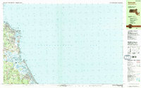
 2012 Scituate2012 Print · USGSCovers Ferry Hill, including Marshfield, Scituate, and other nearby areas
 - 2015 Map of Scituate, 2015 Print
 2015 Scituate2015 Print · USGSCovers Ferry Hill, including Marshfield, Scituate, and other nearby areas
 - 2018 Map of Scituate, 2018 Print
 2018 Scituate2018 Print · USGSCovers Ferry Hill, including Marshfield, Scituate, and other nearby areas
 - 2021 Map of Scituate, 2021 Print
 2021 Scituate2021 Print · USGSCovers Ferry Hill, including Marshfield, Scituate, and other nearby areas
 - 2024 Map of Scituate, 2024 Print
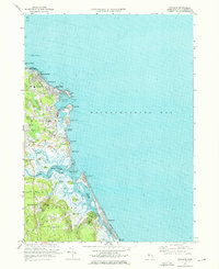
 2024 Scituate2024 Print · USGSCoastal Plymouth County villages and tidal marshes are shown here in modern detail. Genealogists and historians can trace family sites at the Hatch Burial Ground, Union Cem, and the historic neighborhoods of Marshfield Hills.
End of results
Showing maps 1-21 of 21
Top cities near Ferry Hill
- Boston historical maps
- Plymouth historical maps
- Weymouth historical maps
- Bridgewater historical maps
- Marshfield historical maps
- Hingham historical maps
See more
Frequently asked questions
- What are the different types of historical maps available for Ferry Hill?
- What is the oldest map of Ferry Hill?
- Where can I purchase historical maps of Ferry Hill for my home or office?
- Where can I download high-res historical maps of Ferry Hill?
- Are there historical topographic maps available for Ferry Hill?
- Is there historical aerial imagery available for Ferry Hill?
- Where are historical maps of Ferry Hill sourced from?