
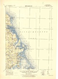
1918 Map of Duxbury
USGS Topo · Published 1918About this map
The coastal defense and maritime infrastructure of Plymouth County are meticulously documented in this 1918 military survey, produced by the Corps of Engineers, U.S. Army. Detailed military notes describe the population, resources, and landing conditions of seaside villages like Scituate and Duxbury, while highlighting tactical assets such as the Old Tower at Cedar Point and the Telegraph Cable to Brest. The sheet reveals a working landscape of coastal industry, from the Saw Mill and Furnace near Marshfield to the cranberry bogs indicated by the Cranberry Pond Cem..
Find a feature on this map
68 named features on this map. Tap any name to fly to it.
Don’t see what you’re looking for? This feature index may not catch every label — zoom into the map to look around manually.
Map Details
Editions of this 1918 Duxbury Map
2 editions found
Other maps of this area

1885 · Abington
USGS Topo · 1:62,500

1885 · Duxbury
USGS Topo · 1:62,500

1885 · Middleboro
USGS Topo · 1:62,500

1886 · Plymouth
USGS Topo · 1:62,500

1888 · Duxbury
USGS Topo · 1:62,500

1888 · Middleboro
USGS Topo · 1:62,500

1888 · Abington
USGS Topo · 1:62,500

1889 · Plymouth
USGS Topo · 1:62,500

1892 · Boston Bay
USGS Topo · 1:62,500

1893 · Abington
USGS Topo · 1:62,500