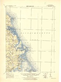
1918 Map of Duxbury
USGS Topo · Published 1921About this map
Massachusetts Bay defines the eastern boundary of this coastal landscape, where the North River and South River wind through the salt marshes of Scituate and Marshfield. The early 20th-century transportation network is clearly defined by several rail stops, including Marshfield Center Sta. and Duxbury Station, supporting the seaside communities and local commerce. Navigational history is marked along the shore at Cedar Point and Gurnet Lights, while the interior shows the remnants of early industry such as the Saw Mill near Marshfield.
Find a feature on this map
68 named features on this map. Tap any name to fly to it.
Don’t see what you’re looking for? This feature index may not catch every label — zoom into the map to look around manually.
Map Details
Editions of this 1918 Duxbury Map
2 editions found

Other maps of this area

1885 · Abington
USGS Topo · 1:62,500

1885 · Duxbury
USGS Topo · 1:62,500

1885 · Middleboro
USGS Topo · 1:62,500

1886 · Plymouth
USGS Topo · 1:62,500

1888 · Duxbury
USGS Topo · 1:62,500

1888 · Middleboro
USGS Topo · 1:62,500

1888 · Abington
USGS Topo · 1:62,500

1889 · Plymouth
USGS Topo · 1:62,500

1892 · Boston Bay
USGS Topo · 1:62,500

1893 · Abington
USGS Topo · 1:62,500