1970s Maps of Third Cliff, Scituate
Explore 2 historic maps of Third Cliff from the 1970s. These maps offer a rare glimpse into what life looked like during the 1970s — showing old roads, neighborhoods, homes, and landmarks that have changed or disappeared over time.
Whether you're researching your family's past, planning a metal detecting trip, or studying how Third Cliff's landscape evolved across the 1970s, these high-resolution maps are a powerful tool for exploring the history of this region.
- Focus on a specific era: All maps on this page are from the 1970s, giving you a focused view of this time period.
- See what’s changed: Compare century-old streets, trails, and buildings to today's modern landscape using overlays and satellite layers.
- Research with precision: Use these maps for genealogy, historical research, land use analysis, or educational projects.
- View, download, or print: Maps are fully viewable online in high resolution, and can be downloaded or printed for your own records.
Start exploring Third Cliff's history through authentic maps from the 1970s. This is your window into the past.
Third Cliff, Scituate maps
(2)- 1974 Map of Scituate, 1976 Print
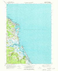 1974 Scituate1976 Print · USGSThe South Shore of Massachusetts in the mid-seventies reveals a mix of coastal resort life and deep-seated maritime history. Genealogists and historians can trace family plots at Union Cem, locate the old Railroad Grade near Greenbush, or study the shoreline at Peggotty Beach.3 unique versions available
 - 1977 Map of Scituate, 1981 Print
 1977 Scituate1981 Print · USGSThe South Shore's tidal estuaries and coastal neighborhoods are captured in this late 1970s aerial survey. Trace the winding paths of the North River and South River as they meet at Humarock and the harbor at Scituate.
End of results
Showing maps 1-2 of 2
Top cities near Third Cliff
- Boston historical maps
- Quincy historical maps
- Plymouth historical maps
- Weymouth historical maps
- Bridgewater historical maps
- Marshfield historical maps
See more
Frequently asked questions
- What are the different types of historical maps available for Third Cliff?
- What is the oldest map of Third Cliff?
- Where can I purchase historical maps of Third Cliff for my home or office?
- Where can I download high-res historical maps of Third Cliff?
- Are there historical topographic maps available for Third Cliff?
- Is there historical aerial imagery available for Third Cliff?
- Where are historical maps of Third Cliff sourced from?