1990s Maps of Boston, Massachusetts
Explore 2 historic maps of Boston from the 1990s. These maps offer a rare glimpse into what life looked like during the 1990s — showing old roads, neighborhoods, homes, and landmarks that have changed or disappeared over time.
Whether you're researching your family's past, planning a metal detecting trip, or studying how Boston's landscape evolved across the 1990s, these high-resolution maps are a powerful tool for exploring the history of this region.
- Focus on a specific era: All maps on this page are from the 1990s, giving you a focused view of this time period.
- See what’s changed: Compare century-old streets, trails, and buildings to today's modern landscape using overlays and satellite layers.
- Research with precision: Use these maps for genealogy, historical research, land use analysis, or educational projects.
- View, download, or print: Maps are fully viewable online in high resolution, and can be downloaded or printed for your own records.
Start exploring Boston's history through authentic maps from the 1990s. This is your window into the past.
Boston, MA maps
(2)- 1997 Map of Lynn, 1999 Print
 1997 Lynn1999 Print · USGSThe North Shore coastline comes into sharp focus during the late twentieth century, showing the dense urban grid of Lynn and the jagged peninsula of Nahant. Genealogists and local historians can trace family locations near Pine Grove Cem, English High Sch, or the many parish schools and temples throughout Swampscott.
 - 1997 Map of Hull, 1999 Print
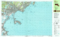
 1997 Hull1999 Print · USGSThe Hull peninsula and Boston's outer harbor islands are shown here in detail during the late 1990s. Genealogists and local historians can trace coastal neighborhoods from Allerton to Kenberma, or locate historic maritime defenses like Fort Warren and Fort Standish.
End of results
Showing maps 1-2 of 2
Top cities near Boston
- Cambridge historical maps
- Brockton historical maps
- Quincy historical maps
- Lynn historical maps
- Newton historical maps
- Somerville historical maps
See more
Top neighborhoods of Boston
- Dorchester Center historical maps
- Roxbury Crossing historical maps
- Fort Warren historical maps
- Hyde Park historical maps
- Jamaica Plain historical maps
- Brighton historical maps
See more
Frequently asked questions
- What are the different types of historical maps available for Boston?
- What is the oldest map of Boston?
- Where can I purchase historical maps of Boston for my home or office?
- Where can I download high-res historical maps of Boston?
- Are there historical topographic maps available for Boston?
- Is there historical aerial imagery available for Boston?
- Where are historical maps of Boston sourced from?