1980s Maps of Milford, Massachusetts
Explore 6 historic maps of Milford from the 1980s. These maps offer a rare glimpse into what life looked like during the 1980s — showing old roads, neighborhoods, homes, and landmarks that have changed or disappeared over time.
Whether you're researching your family's past, planning a metal detecting trip, or studying how Milford's landscape evolved across the 1980s, these high-resolution maps are a powerful tool for exploring the history of this region.
- Focus on a specific era: All maps on this page are from the 1980s, giving you a focused view of this time period.
- See what’s changed: Compare century-old streets, trails, and buildings to today's modern landscape using overlays and satellite layers.
- Research with precision: Use these maps for genealogy, historical research, land use analysis, or educational projects.
- View, download, or print: Maps are fully viewable online in high resolution, and can be downloaded or printed for your own records.
Start exploring Milford's history through authentic maps from the 1980s. This is your window into the past.
Milford, MA maps
(6)- 1982 Map of Uxbridge, 1984 Print
 1982 Uxbridge1984 Print · USGSThe Blackstone Valley at the start of the eighties shows a landscape of historic mill towns and river-driven industry. Researchers can trace family ties and civic growth through sites like the Chestnut Hill Meeting House, Northbridge High Sch, and Evergreen Cem.
 - 1982 Map of Milford, 1984 Print
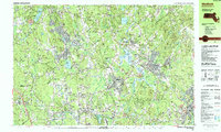
 1982 Milford1984 Print · USGSCentral Massachusetts in the early eighties reveals a landscape of industrial river towns and sprawling state forests. Genealogists and historians can trace the mill villages along the Blackstone River or locate old burial grounds like Indian Cem and Riverdale Cem.
 - 1985 Map of Boston, 1986 Print
 1985 Boston1986 Print · USGSThe Massachusetts urban core and its expanding suburbs are captured in the mid-eighties, showing the reach of the Mass Turnpike and Route 128. Genealogists and historians can trace the evolution of towns from Lexington to Waltham, locating landmarks like Harvard University and Minute Man National Historical Park.
 - 1987 Map of Medfield
 1987 Medfield1987 Print · USGSThe Charles River valley communities of Norfolk and Middlesex Counties reached a peak of suburban and institutional maturity during the 1980s. Local researchers can trace the footprint of the Medfield State Hospital, locate family plots in Lake Grove Cem, or follow the CONRAIL line through Gooch Corners and Millis.2 unique versions available
 - 1987 Map of Franklin
 1987 Franklin1987 Print · USGSFranklin and the Norfolk County borderlands are shown in the late eighties during a period of established institutional and suburban growth. Researchers can locate specific sites like the Wrentham State School, Dean Jr College, and the extensive Franklin State Forest.2 unique versions available
 - 1989 Map of Boston
 1989 Boston1989 Print · USGSGreater Boston and the central Massachusetts corridor appear here in the late eighties as suburban growth reshaped the region. Genealogists and historians can trace the transit networks between Boston, Worcester, and Quincy, while locating landmarks like Bunker Hill Monument and Wachusett Reservoir.2 unique versions available
End of results
Showing maps 1-6 of 6
Top cities near Milford
- Worcester historical maps
- Framingham historical maps
- Attleboro historical maps
- Woonsocket historical maps
- Marlborough historical maps
- Cumberland historical maps
See more
Top neighborhoods of Milford
Frequently asked questions
- What are the different types of historical maps available for Milford?
- What is the oldest map of Milford?
- Where can I purchase historical maps of Milford for my home or office?
- Where can I download high-res historical maps of Milford?
- Are there historical topographic maps available for Milford?
- Is there historical aerial imagery available for Milford?
- Where are historical maps of Milford sourced from?