1950s Maps of Oxford, Massachusetts
Explore 5 historic maps of Oxford from the 1950s. These maps offer a rare glimpse into what life looked like during the 1950s — showing old roads, neighborhoods, homes, and landmarks that have changed or disappeared over time.
Whether you're researching your family's past, planning a metal detecting trip, or studying how Oxford's landscape evolved across the 1950s, these high-resolution maps are a powerful tool for exploring the history of this region.
- Focus on a specific era: All maps on this page are from the 1950s, giving you a focused view of this time period.
- See what’s changed: Compare century-old streets, trails, and buildings to today's modern landscape using overlays and satellite layers.
- Research with precision: Use these maps for genealogy, historical research, land use analysis, or educational projects.
- View, download, or print: Maps are fully viewable online in high resolution, and can be downloaded or printed for your own records.
Start exploring Oxford's history through authentic maps from the 1950s. This is your window into the past.
Oxford, MA maps
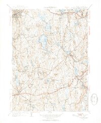
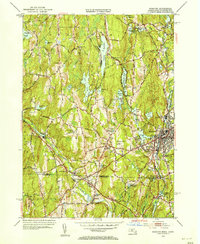
(5)- 1953 Map of Oxford, 1954 Print
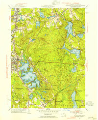 1953 Oxford1954 Print · USGSSouthern Worcester County was a busy intersection of industry and nature in the early fifties. Trace the rail lines of the New York New Haven and Hartford and locate landmarks like the St Joseph Cem and the sprawling Lake Chaubunagungamaug.3 unique versions available
 - 1953 Map of Leicester, 1954 Print
 1953 Leicester1954 Print · USGSCentral Massachusetts in the early fifties showcases a landscape of mill towns and rail corridors. Trace family history at the Clara Barton Home or locate ancestors in Pine Grove Cem and Northside Cem.3 unique versions available
 - 1953 Map of Webster, 1955 Print
 1953 Webster1955 Print · USGSThe Massachusetts and Connecticut borderlands thrive during the early fifties, anchored by the industrial hub of Webster. Researchers can trace the rail lines of the New York New Haven and Hartford RR or locate Nichols College, Fabyan, and South Charlton.3 unique versions available
 - 1956 Map of Boston, 1967 Print
 1956 Boston1967 Print · USGSThe Massachusetts coastline and industrial interior are seen here during the mid-century peak of suburban and highway expansion. Researchers can trace historic harbor defenses like Fort Revere, local landmarks such as Faneuil Hall, and the vast Parker River National Wildlife Refuge.6 unique versions available
 - 1958 Map of Boston
 1958 Boston1958 Print · USGSEastern Massachusetts and southern New Hampshire are shown at the height of the industrial era, before the full expansion of the interstate system. Trace coastal defenses at Fort Warren, historic rail lines like the Boston and Maine, and the development of the Mass. 128 corridor.2 unique versions available
End of results
Showing maps 1-5 of 5
Top cities near Oxford
- Worcester historical maps
- Shrewsbury historical maps
- Westborough historical maps
- Webster historical maps
- Grafton historical maps
- Southbridge historical maps
See more
Top neighborhoods of Oxford
- Cominsville historical maps
- North Oxford historical maps
- Texas historical maps
- Buffumville historical maps
- Camp Barton historical maps
- Hodges Village historical maps
See more
Frequently asked questions
- What are the different types of historical maps available for Oxford?
- What is the oldest map of Oxford?
- Where can I purchase historical maps of Oxford for my home or office?
- Where can I download high-res historical maps of Oxford?
- Are there historical topographic maps available for Oxford?
- Is there historical aerial imagery available for Oxford?
- Where are historical maps of Oxford sourced from?