Old Maps of Rutland, Massachusetts for Hiking & Exploration
Hike through history with 66 historic maps of Rutland. Explore old trails, ghost towns, and forgotten backroads — perfect for outdoor adventurers and local explorers.
- Rediscover forgotten places: Map out old mining camps, roads, and footpaths that no longer exist on modern maps.
- Layer with modern tools: Combine with LiDAR or satellite views to plan hikes through historical terrain.
- Made for exploration: Popular among hikers, overlanders, and local history lovers.
Use these maps to find adventure and explore the hidden past of Rutland.
Rutland, MA maps
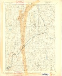
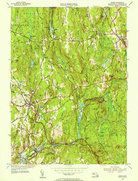
(66)- 1885 Map of Worcester
 1885 Worcester1885 Print · USGSWorcester and its surrounding mill towns are captured here in the late nineteenth century during a peak era of rail expansion and industrial growth. Researchers can trace ancestral roots through specific local hubs like Wire Village, the Sterling Camp Grounds, and the grounds of the State Lunatic Hospital.
 - 1886 Map of Worcester
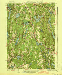
 1886 Worcester1886 Print · USGSWorcester and its surrounding hill towns are captured here in the mid-1880s, revealing a landscape of early industrial hamlets and expanding rail lines. Genealogists and local historians can trace the foundations of the State Lunatic Hospital or locate historic settlements like Quinapoxet Village and Wire Village.
 - 1887 Map of Barre
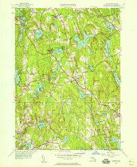
 1887 Barre1887 Print · USGSWorcester County at the turn of the century shows a landscape defined by the convergence of rail lines and river power. Genealogists and local researchers can trace the early industrial footprints of Old Furnace, Parkers Mills, and the rail junction at Cold Brook Springs.
 - 1889 Map of Barre
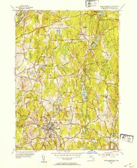
 1889 Barre1889 Print · USGSWorcester County in the late nineteenth century is a landscape of thriving mill villages and intersecting rail lines. Trace the industrial roots of Gilbertville and Old Furnace or locate family homesteads near Mandell and Nichewaug.
 - 1892 Map of Worcester
 1892 Worcester1892 Print · USGSWorcester and its northern hill towns are captured here in the late nineteenth century before the expansion of modern reservoirs. Researchers can trace the early rail networks through Sterling Junction or locate landmarks like the State Lunatic Hospital and Wire Village.10 unique versions available
 - 1894 Map of Barre
 1894 Barre1894 Print · USGSWorcester County in the late nineteenth century is defined here by its bustling river towns and the convergence of two major rail lines. Researchers can trace ancestral roots through family-named landmarks like Hawes Hill or explore the early industrial layout of Old Furnace and Barre Plains.7 unique versions available
 - 1908 Map of Quinsigamond
 1908 Quinsigamond1908 Print · USGSCentral Massachusetts and its bordering states are seen here in the early twentieth century as industry and transit reshaped the Blackstone Valley. Genealogists and historians can trace the early footprints of Worcester, the expansion of the Wachusett Reservoir, and rail lines like the Boston and Albany Railroad.3 unique versions available
 - 1908 Map of Ware
 1908 Ware1908 Print · USGSCentral Massachusetts at the turn of the century reveals the Swift River Valley decades before the Quabbin Reservoir changed the landscape forever. Trace the lost footprints of Enfield and Dana, or follow the Central Vermont RR through Greenwich Village and Ware.2 unique versions available
 - 1937 Map of Paxton
 1937 Paxton1937 Print · USGSWorcester County's upland terrain is captured here in the late 1930s, featuring a landscape of hill-top settlements and industrial hamlets. Genealogists and historians can trace the foundations of Upper Wire Village, locate the Veterans Hospital, or explore the shores of Lake Whittemore.
 - 1939 Map of Wachusett Mtn
 1939 Wachusett Mtn1939 Print · USGSWorcester County is captured here in the late 1930s, showing the intersection of new state infrastructure and historic rail villages. Researchers can trace family sites at Woodlawn Cem or follow the engineering of the Quabbin Aqueduct near Hubbardston Sta.
 - 1940 Map of Wachusett Mtn
 1940 Wachusett Mtn1940 Print · USGSCentral Massachusetts hill country and valley settlements are captured here just before the 1940s. Genealogists and historians can trace the Boston and Maine Railroad lines and locate the State Sanatorium or Rural Glen Cem.2 unique versions available
 - 1941 Map of Paxton
 1941 Paxton1941 Print · USGSPaxton and the high country of Worcester County are captured here in the early 1940s, showing a region of reservoirs and rural industry. Genealogists can locate family landmarks at Tafts Corner or trace the early industrial sites of Upper Wire Village.3 unique versions available
 - 1942 Map of Ware
 1942 Ware1942 Print · USGSCentral Massachusetts and the Connecticut border are captured here during the early years of the war, just as the landscape was being reshaped by the Quabbin Reservoir. Researchers can trace rail-era industry and local landmarks like the Lead Mine and the Bald Peak Hospital.
 - 1942 Map of Wachusett Mtn.
 1942 Wachusett Mtn.1942 Print · USGSThe Worcester County highlands appear in the late 1930s as a landscape of mountain trails, sanatoriums, and rail corridors. You can trace the Boston and Maine Railroad past Princeton Sta or locate the aqueduct shafts and cemeteries like Woodlawn Cem.2 unique versions available
 - 1943 Map of Quinsigamond
 1943 Quinsigamond1943 Print · USGSCentral Massachusetts and its bordering states appear here during the Second World War as a powerhouse of rail infrastructure and public institutions. Researchers can trace the legacy of the region through landmarks like Grafton State Hospital, the Wachusett Reservoir, and the deep industrial roots of the Blackstone River.
 - 1946 Map of Barre
 1946 Barre1946 Print · USGSWorcester County's industrial and forest lands are captured in the 1940s as the Ware River corridor served both local mills and regional water needs. Genealogists and historians can trace rail lines like the Boston and Albany Railroad and locate local landmarks such as Glen Valley Cem and the Fairgrounds.2 unique versions available
 - 1946 Map of Wachusett Mtn
 1946 Wachusett Mtn1946 Print · USGSWorcester County's highland terrain is captured here in the years following the war, showing the industrial waterworks and sanatoriums of the era. Genealogists and local historians can trace the Boston and Maine Railroad lines and locate Rural Glen Cem or the Central New England Sanitorium.3 unique versions available
 - 1946 Map of North Brookfield
 1946 North Brookfield1946 Print · USGSWorcester County townships like North Brookfield and Hillsville are captured here just after the war, showing a landscape defined by industry and agriculture. Researchers can locate family landmarks including Pine Grove Cem, Port Hill Sch, and the Boston and Albany RR line.2 unique versions available
 - 1948 Map of Boston
 1948 Boston1948 Print · USGSEastern Massachusetts and southern New Hampshire appear at an industrial peak in the late 1940s, just as suburban growth began to accelerate. Genealogists and historians can trace rail lines like the Boston and Albany RR or locate coastal landmarks like Graves Lighthouse and Fort Devens.2 unique versions available
 - 1948 Map of Albany, 1951 Print
 1948 Albany1951 Print · USGSThe Hudson and Connecticut River valleys are captured here in the late 1940s, showing the vital rail and water corridors of the Northeast. You can trace the Boston and Maine tracks past Mt Greylock or locate early settlements like Great Barrington and Bennington.
 - 1950 Map of Paxton, 1958 Print
 1950 Paxton1958 Print · USGSThe hill country of central Massachusetts is revealed here at mid-century, featuring the intersection of industrial villages and municipal water systems. Genealogists and historians can locate legacy sites like Upper Wire Village, the State Sanitorium, and Quaker Cem.2 unique versions available
 - 1952 Map of North Brookfield, 1954 Print
 1952 North Brookfield1954 Print · USGSCentral Massachusetts in the early fifties reveals a landscape of high hills and tight-knit villages. Genealogists and historians can trace family plots at Green Hollow Cem, locate the grounds of St Josephs Abbey, or follow old routes like the Old Turnpike Road.4 unique versions available
 - 1954 Map of Barre, 1955 Print
 1954 Barre1955 Print · USGSThe Ware River valley in the mid-1950s reveals a landscape of industrial mill villages and quiet upland forests across Worcester County. Genealogists and historians can trace family plots at Nightingale Cem or follow the route of the old Boston and Albany Turnpike through Coldbrook Springs.4 unique versions available
 - 1956 Map of Wachusett Mtn, 1959 Print
 1956 Wachusett Mtn1959 Print · USGSThe foothills of Worcester County are shown in the late 1950s, a time when sanatoriums and rail depots still defined the local character. Researchers can locate long-standing landmarks like the Rutland State Sanatorium, Hubbardston Sta, and Goose Hill Cem.2 unique versions available
 - 1956 Map of Boston, 1967 Print
 1956 Boston1967 Print · USGSThe Massachusetts coastline and industrial interior are seen here during the mid-century peak of suburban and highway expansion. Researchers can trace historic harbor defenses like Fort Revere, local landmarks such as Faneuil Hall, and the vast Parker River National Wildlife Refuge.6 unique versions available
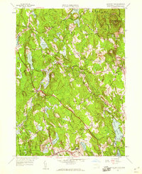
Showing maps 1-25 of 66
Top cities near Rutland
- Worcester historical maps
- Leominster historical maps
- Fitchburg historical maps
- Shrewsbury historical maps
- Gardner historical maps
- Holden historical maps
See more
Top neighborhoods of Rutland
- New Boston historical maps
- North Rutland historical maps
- Sandy Beach historical maps
- Muschopauge historical maps
- Turkey Hill Shores historical maps
- West Rutland historical maps
Frequently asked questions
- What are the different types of historical maps available for Rutland?
- What is the oldest map of Rutland?
- Where can I purchase historical maps of Rutland for my home or office?
- Where can I download high-res historical maps of Rutland?
- Are there historical topographic maps available for Rutland?
- Is there historical aerial imagery available for Rutland?
- Where are historical maps of Rutland sourced from?