1970s Maps of Sutton, Massachusetts
Explore 5 historic maps of Sutton from the 1970s. These maps offer a rare glimpse into what life looked like during the 1970s — showing old roads, neighborhoods, homes, and landmarks that have changed or disappeared over time.
Whether you're researching your family's past, planning a metal detecting trip, or studying how Sutton's landscape evolved across the 1970s, these high-resolution maps are a powerful tool for exploring the history of this region.
- Focus on a specific era: All maps on this page are from the 1970s, giving you a focused view of this time period.
- See what’s changed: Compare century-old streets, trails, and buildings to today's modern landscape using overlays and satellite layers.
- Research with precision: Use these maps for genealogy, historical research, land use analysis, or educational projects.
- View, download, or print: Maps are fully viewable online in high resolution, and can be downloaded or printed for your own records.
Start exploring Sutton's history through authentic maps from the 1970s. This is your window into the past.
Sutton, MA maps
(5)- 1973 Map of Worcester South, 1976 Print
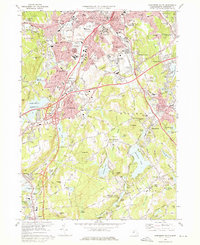 1973 Worcester South1976 Print · USGSSouthern Worcester and Auburn are seen here in the early seventies as suburban growth meets long-standing industrial and academic centers. Researchers can trace family sites at Hope Cemetery, locate the Drive-in Theater, or study the Penn Central rail corridor.2 unique versions available
 - 1975 Map of Uxbridge, 1981 Print
 1975 Uxbridge1981 Print · USGSThe industrial landscape of the Blackstone Valley comes into focus in the mid-1970s, showing the intersection of river-power and rail-era mill towns. Researchers can trace the developed centers of Uxbridge and Whitinsville or locate the smaller settlement at Tasseltop.
 - 1975 Map of Grafton, 1981 Print
 1975 Grafton1981 Print · USGSThe Blackstone Valley and its mill villages are seen here in the mid-seventies through detailed aerial photography. Researchers can trace the development of historic centers like Fisherville and Wilkinsonville along the Blackstone River.
 - 1975 Map of Oxford, 1981 Print
 1975 Oxford1981 Print · USGSSouthern Worcester County in the mid-seventies is captured here via detailed aerial imagery. Researchers can trace the shoreline of Lake Chaubunagungamaug or survey the dense canopy of Douglas Woods and the village of Manchaug.
 - 1975 Map of Worcester South, 1981 Print
 1975 Worcester South1981 Print · USGSCentral Massachusetts undergoes significant suburban growth in the 1970s as highway networks expand across the Blackstone Valley. Researchers can trace land use and development patterns near Auburn, Bramanville, and the Blackstone River.
End of results
Showing maps 1-5 of 5
Top cities near Sutton
- Worcester historical maps
- Woonsocket historical maps
- Marlborough historical maps
- Shrewsbury historical maps
- Milford historical maps
- Smithfield historical maps
See more
Top neighborhoods of Sutton
- East Sutton historical maps
- Wilkinsonville historical maps
- Manchaug historical maps
- West Sutton historical maps
- Marions Camp historical maps
- South Sutton historical maps
See more
Frequently asked questions
- What are the different types of historical maps available for Sutton?
- What is the oldest map of Sutton?
- Where can I purchase historical maps of Sutton for my home or office?
- Where can I download high-res historical maps of Sutton?
- Are there historical topographic maps available for Sutton?
- Is there historical aerial imagery available for Sutton?
- Where are historical maps of Sutton sourced from?