1940s Maps of Templeton, Massachusetts
Explore 8 historic maps of Templeton from the 1940s. These maps offer a rare glimpse into what life looked like during the 1940s — showing old roads, neighborhoods, homes, and landmarks that have changed or disappeared over time.
Whether you're researching your family's past, planning a metal detecting trip, or studying how Templeton's landscape evolved across the 1940s, these high-resolution maps are a powerful tool for exploring the history of this region.
- Focus on a specific era: All maps on this page are from the 1940s, giving you a focused view of this time period.
- See what’s changed: Compare century-old streets, trails, and buildings to today's modern landscape using overlays and satellite layers.
- Research with precision: Use these maps for genealogy, historical research, land use analysis, or educational projects.
- View, download, or print: Maps are fully viewable online in high resolution, and can be downloaded or printed for your own records.
Start exploring Templeton's history through authentic maps from the 1940s. This is your window into the past.
Templeton, MA maps
(8)- 1942 Map of Keene
 1942 Keene1942 Print · USGSCheshire County at the start of the war shows a landscape of busy river valleys and upland farms. You can trace the path of the Boston & Maine RR through towns like Westmoreland and find old district landmarks like Sch No 10 or the Rand Cem.
 - 1942 Map of Ware
 1942 Ware1942 Print · USGSCentral Massachusetts and the Connecticut border are captured here during the early years of the war, just as the landscape was being reshaped by the Quabbin Reservoir. Researchers can trace rail-era industry and local landmarks like the Lead Mine and the Bald Peak Hospital.
 - 1946 Map of Barre
 1946 Barre1946 Print · USGSWorcester County's industrial and forest lands are captured in the 1940s as the Ware River corridor served both local mills and regional water needs. Genealogists and historians can trace rail lines like the Boston and Albany Railroad and locate local landmarks such as Glen Valley Cem and the Fairgrounds.2 unique versions available
 - 1946 Map of Winchendon
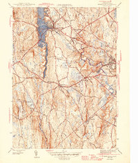
 1946 Winchendon1946 Print · USGSPost-war Worcester County and southern New Hampshire come to life in this survey of mill towns and rail corridors. Trace family roots and local history through Winchendon Springs, the Riverside Cem, and landmarks along the Millers River.2 unique versions available
 - 1946 Map of Royalston
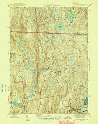 1946 Royalston1946 Print · USGSNorthern Worcester County comes alive in this mid-century survey of Royalston and its hill-country neighbors. Genealogists and historians can trace family sites at Neale Place or follow the Boston and Maine Railroad along the Millers River.2 unique versions available
 - 1946 Map of Templeton
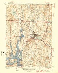
 1946 Templeton1946 Print · USGSTempleton and the surrounding Worcester County townships are shown just after the war when rail lines and textile-era villages still defined the local landscape. Researchers can trace historic sites like the Fernald State School, Gardner Landing Field, and the Baptist Common Cem.2 unique versions available
 - 1946 Map of Athol
 1946 Athol1946 Print · USGSPost-war Worcester County comes into focus as a landscape of river-driven industry and upland forestry. Researchers can trace historic family burial sites at Silver Lake Cem or explore the academic legacy of the Administration Bldg Harvard Forest.2 unique versions available
 - 1948 Map of Albany, 1951 Print
 1948 Albany1951 Print · USGSThe Hudson and Connecticut River valleys are captured here in the late 1940s, showing the vital rail and water corridors of the Northeast. You can trace the Boston and Maine tracks past Mt Greylock or locate early settlements like Great Barrington and Bennington.
End of results
Showing maps 1-8 of 8
Top cities near Templeton
- Worcester historical maps
- Fitchburg historical maps
- Gardner historical maps
- Holden historical maps
- Athol historical maps
- Winchendon historical maps
See more
Top neighborhoods of Templeton
- Templeton Station historical maps
- East Templeton historical maps
- Otter River historical maps
- Partidgeville historical maps
- Partridgeville historical maps
- Brooks Village historical maps
See more
Frequently asked questions
- What are the different types of historical maps available for Templeton?
- What is the oldest map of Templeton?
- Where can I purchase historical maps of Templeton for my home or office?
- Where can I download high-res historical maps of Templeton?
- Are there historical topographic maps available for Templeton?
- Is there historical aerial imagery available for Templeton?
- Where are historical maps of Templeton sourced from?