Old Maps of Templeton, Massachusetts for Genealogy
Trace your family roots with 66 historic maps of Templeton. These high-res maps reveal old neighborhoods, homesites, landmarks, and streets — helping you uncover where your ancestors lived and how the area evolved over time.
- Explore historic neighborhoods: Identify where your relatives may have lived in the 1800s or 1900s.
- Compare maps over time: Trace the changes in streets, buildings, and landmarks for multi-generational research.
- Perfect for genealogy & ancestry research: Used by family historians and researchers to map out lineage and migration.
These maps are an incredible resource for exploring your personal connection to Templeton's past.
Templeton, MA maps
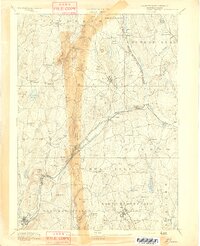
(66)- 1887 Map of Winchendon
 1887 Winchendon1887 Print · USGSNorth-central Massachusetts and the New Hampshire borderlands are captured here during a peak era of rail expansion and water-powered industry. Researchers can trace historic mill sites and depot locations such as Powers Mills, Pequoig Station, and the busy rail junction at Baldwinville.
 - 1887 Map of Barre
 1887 Barre1887 Print · USGSWorcester County at the turn of the century shows a landscape defined by the convergence of rail lines and river power. Genealogists and local researchers can trace the early industrial footprints of Old Furnace, Parkers Mills, and the rail junction at Cold Brook Springs.
 - 1889 Map of Barre
 1889 Barre1889 Print · USGSWorcester County in the late nineteenth century is a landscape of thriving mill villages and intersecting rail lines. Trace the industrial roots of Gilbertville and Old Furnace or locate family homesteads near Mandell and Nichewaug.
 - 1890 Map of Winchendon
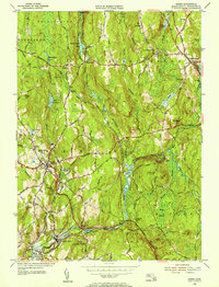
 1890 Winchendon1890 Print · USGSThe Worcester County borderlands at the end of the 19th century reveal a complex landscape of mill villages and hilltop commons. Researchers can trace the early industrial footprint at Powers Mills, find the rail junction at Pequoig Station, and locate the ancestral centers of Royalston Center or Templeton Center.
 - 1894 Map of Winchendon
 1894 Winchendon1894 Print · USGSNorth-central Massachusetts and the New Hampshire border are captured here during a peak era of rail-driven industry. Genealogists and historians can trace the development of mill villages and family landmarks like Powers Mills, Baldwinville, and the Cheshire Railroad.6 unique versions available
 - 1894 Map of Barre
 1894 Barre1894 Print · USGSWorcester County in the late nineteenth century is defined here by its bustling river towns and the convergence of two major rail lines. Researchers can trace ancestral roots through family-named landmarks like Hawes Hill or explore the early industrial layout of Old Furnace and Barre Plains.7 unique versions available
 - 1908 Map of Ware
 1908 Ware1908 Print · USGSCentral Massachusetts at the turn of the century reveals the Swift River Valley decades before the Quabbin Reservoir changed the landscape forever. Trace the lost footprints of Enfield and Dana, or follow the Central Vermont RR through Greenwich Village and Ware.2 unique versions available
 - 1932 Map of Winchendon
 1932 Winchendon1932 Print · USGSThe borderlands of New Hampshire and Massachusetts come into focus during the early thirties, showing a rural landscape dominated by glacial lakes and high ridges. Researchers can trace the Boston and Maine line through State Line or locate family sites at Rand Cem and Sch No 1.
 - 1935 Map of Winchendon
 1935 Winchendon1935 Print · USGSIn the mid-1930s, the border between Massachusetts and New Hampshire was defined by busy rail corridors and small mill towns. Researchers can trace family-named sites and industrial infrastructure from Athol Center to Pequoig Station and the rural School No 1.4 unique versions available
 - 1942 Map of Keene
 1942 Keene1942 Print · USGSCheshire County at the start of the war shows a landscape of busy river valleys and upland farms. You can trace the path of the Boston & Maine RR through towns like Westmoreland and find old district landmarks like Sch No 10 or the Rand Cem.
 - 1942 Map of Ware
 1942 Ware1942 Print · USGSCentral Massachusetts and the Connecticut border are captured here during the early years of the war, just as the landscape was being reshaped by the Quabbin Reservoir. Researchers can trace rail-era industry and local landmarks like the Lead Mine and the Bald Peak Hospital.
 - 1946 Map of Barre
 1946 Barre1946 Print · USGSWorcester County's industrial and forest lands are captured in the 1940s as the Ware River corridor served both local mills and regional water needs. Genealogists and historians can trace rail lines like the Boston and Albany Railroad and locate local landmarks such as Glen Valley Cem and the Fairgrounds.2 unique versions available
 - 1946 Map of Winchendon
 1946 Winchendon1946 Print · USGSPost-war Worcester County and southern New Hampshire come to life in this survey of mill towns and rail corridors. Trace family roots and local history through Winchendon Springs, the Riverside Cem, and landmarks along the Millers River.2 unique versions available
 - 1946 Map of Royalston
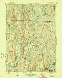 1946 Royalston1946 Print · USGSNorthern Worcester County comes alive in this mid-century survey of Royalston and its hill-country neighbors. Genealogists and historians can trace family sites at Neale Place or follow the Boston and Maine Railroad along the Millers River.2 unique versions available
 - 1946 Map of Templeton
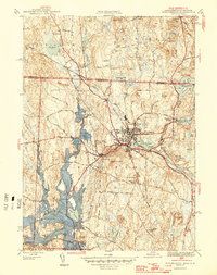
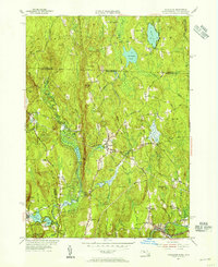
 1946 Templeton1946 Print · USGSTempleton and the surrounding Worcester County townships are shown just after the war when rail lines and textile-era villages still defined the local landscape. Researchers can trace historic sites like the Fernald State School, Gardner Landing Field, and the Baptist Common Cem.2 unique versions available
 - 1946 Map of Athol
 1946 Athol1946 Print · USGSPost-war Worcester County comes into focus as a landscape of river-driven industry and upland forestry. Researchers can trace historic family burial sites at Silver Lake Cem or explore the academic legacy of the Administration Bldg Harvard Forest.2 unique versions available
 - 1948 Map of Albany, 1951 Print
 1948 Albany1951 Print · USGSThe Hudson and Connecticut River valleys are captured here in the late 1940s, showing the vital rail and water corridors of the Northeast. You can trace the Boston and Maine tracks past Mt Greylock or locate early settlements like Great Barrington and Bennington.
 - 1954 Map of Barre, 1955 Print
 1954 Barre1955 Print · USGSThe Ware River valley in the mid-1950s reveals a landscape of industrial mill villages and quiet upland forests across Worcester County. Genealogists and historians can trace family plots at Nightingale Cem or follow the route of the old Boston and Albany Turnpike through Coldbrook Springs.4 unique versions available
 - 1954 Map of Winchendon, 1955 Print
 1954 Winchendon1955 Print · USGSNorthwestern Worcester County comes to life in the mid-1950s, showing a landscape defined by mill ponds and early manufacturing hamlets. Trace family roots at Riverside Cem or locate the sites of Harrisville, Bullardville, and the Woodcock Sch.3 unique versions available
 - 1954 Map of Royalston, 1955 Print
 1954 Royalston1955 Print · USGSThe Worcester County highlands and the New Hampshire border are documented here in the mid-fifties as the railroad era transitioned into the age of modern state highways. Researchers can trace ancestral locations near the Raymond Sch, follow the path of the Boston and Maine Railroad, or locate landmarks like Doane Falls.3 unique versions available
 - 1954 Map of Templeton, 1956 Print
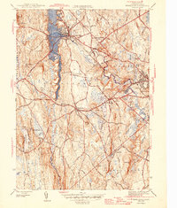
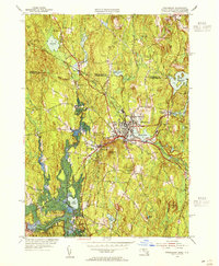
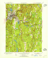
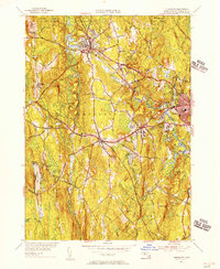 1954 Templeton1956 Print · USGSCentral Massachusetts reveals its mid-century industrial and institutional roots in this map of the Templeton area. Trace the legacy of rail and river through Baldwinsville and Otter River, or find family landmarks like Greenlawn Cem and the Fernald State Sch.3 unique versions available
 - 1954 Map of Athol, 1956 Print
 1954 Athol1956 Print · USGSAthol and Phillipston are captured during the mid-fifties, showing a landscape defined by the Millers River industry and the extensive Harvard Forest. Researchers can locate numerous burial sites like Doe Valley Cem and industrial markers such as the Phillipston Mill.3 unique versions available
 - 1956 Map of Albany, 1968 Print
 1956 Albany1968 Print · USGSThe industrial heart of the Northeast is revealed in the mid-1950s, from the Hudson Valley to the Connecticut River. Researchers can trace the legacy of the Quabbin Reservoir, locate Westover Air Force Base, or follow the Rutland RR through the Green Mountains.2 unique versions available
 - 1957 Map of Albany
 1957 Albany1957 Print · USGSThe Tri-State region and Connecticut River Valley are captured here during a period of significant postwar growth and infrastructure expansion. Genealogists and historians can trace the rail-and-river economy through landmarks like the Boston and Maine railroad, Quabbin Reservoir, and Westover Air Force Base.
 - 1959 Map of Albany
 1959 Albany1959 Print · USGSThe Hudson and Connecticut River valleys are captured here during the late fifties, showing the region's dense rail networks and massive water projects. Researchers can trace the New York State Thruway or locate local landmarks like Mt Greylock and the Quabbin Reservoir.
Showing maps 1-25 of 66
Top cities near Templeton
- Worcester historical maps
- Fitchburg historical maps
- Gardner historical maps
- Holden historical maps
- Athol historical maps
- Winchendon historical maps
See more
Top neighborhoods of Templeton
- Templeton Station historical maps
- East Templeton historical maps
- Otter River historical maps
- Partidgeville historical maps
- Partridgeville historical maps
- Brooks Village historical maps
See more
Frequently asked questions
- What are the different types of historical maps available for Templeton?
- What is the oldest map of Templeton?
- Where can I purchase historical maps of Templeton for my home or office?
- Where can I download high-res historical maps of Templeton?
- Are there historical topographic maps available for Templeton?
- Is there historical aerial imagery available for Templeton?
- Where are historical maps of Templeton sourced from?