1980s Maps of Burt Township, Michigan
Explore 3 historic maps of Burt Township from the 1980s. These maps offer a rare glimpse into what life looked like during the 1980s — showing old roads, neighborhoods, homes, and landmarks that have changed or disappeared over time.
Whether you're researching your family's past, planning a metal detecting trip, or studying how Burt Township's landscape evolved across the 1980s, these high-resolution maps are a powerful tool for exploring the history of this region.
- Focus on a specific era: All maps on this page are from the 1980s, giving you a focused view of this time period.
- See what’s changed: Compare century-old streets, trails, and buildings to today's modern landscape using overlays and satellite layers.
- Research with precision: Use these maps for genealogy, historical research, land use analysis, or educational projects.
- View, download, or print: Maps are fully viewable online in high resolution, and can be downloaded or printed for your own records.
Start exploring Burt Township's history through authentic maps from the 1980s. This is your window into the past.
Burt Township, MI maps
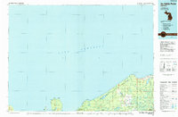
(3)- 1983 Map of Trappers Lake, 1984 Print
 1983 Trappers Lake1984 Print · USGSThe Lake Superior shoreline and Pictured Rocks backcountry are preserved here in the early 1980s. Researchers can trace the network of old woods routes and trails, including Adams Trail, and locate remote landmarks like Buck Hill and Trappers Lake.
 - 1984 Map of Au Sable Point, 1985 Print
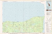
 1984 Au Sable Point1985 Print · USGSThe Lake Superior shoreline in the mid-1980s reveals the vast protected reaches of the Upper Peninsula. Trace maritime history through the Au Sable Point Lighthouse and explore the inland timber legacy along the Old Grade Railroad.2 unique versions available
 - 1985 Map of Two Hearted River
 1985 Two Hearted River1985 Print · USGSThe Lake Superior coast of the Upper Peninsula is shown here during the mid-1980s, stretching from the Sucker River to Whitefish Bay. Researchers can trace remote logging grades and find small settlements such as Deer Park, Emerson, and the notable Pine Stump Junction.2 unique versions available
End of results
Showing maps 1-3 of 3
Top neighborhoods of Burt Township
- Green Haven historical maps
- Sullivans Landing historical maps
- Sunrise Landing historical maps
- Grand Marais historical maps
Frequently asked questions
- What are the different types of historical maps available for Burt Township?
- What is the oldest map of Burt Township?
- Where can I purchase historical maps of Burt Township for my home or office?
- Where can I download high-res historical maps of Burt Township?
- Are there historical topographic maps available for Burt Township?
- Is there historical aerial imagery available for Burt Township?
- Where are historical maps of Burt Township sourced from?