1970s Maps of Benzie County, Michigan
Explore 8 historic maps of Benzie County from the 1970s. These maps offer a rare glimpse into what life looked like during the 1970s — showing old roads, neighborhoods, homes, and landmarks that have changed or disappeared over time.
Whether you're researching your family's past, planning a metal detecting trip, or studying how Benzie County's landscape evolved across the 1970s, these high-resolution maps are a powerful tool for exploring the history of this region.
- Focus on a specific era: All maps on this page are from the 1970s, giving you a focused view of this time period.
- See what’s changed: Compare century-old streets, trails, and buildings to today's modern landscape using overlays and satellite layers.
- Research with precision: Use these maps for genealogy, historical research, land use analysis, or educational projects.
- View, download, or print: Maps are fully viewable online in high resolution, and can be downloaded or printed for your own records.
Start exploring Benzie County's history through authentic maps from the 1970s. This is your window into the past.
Benzie County, MI maps
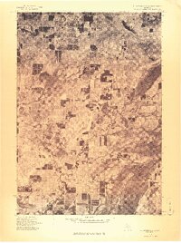
(8)- 1976 Map of Thompsonville NE
 1976 Thompsonville NE1976 Print · USGSGrand Traverse County's lake-studded landscape is captured in this mid-1970s aerial survey just as these lakeside communities were evolving. You can trace the rural layouts of Lake Ann and Bendon or examine the shorelines of Long Lake and Green Lake.
 - 1976 Map of Frankfort SE
 1976 Frankfort SE1976 Print · USGSIn the mid-seventies, this area of Benzie County preserved a classic northern Michigan landscape of winding waterways and village life. Researchers can trace the exact footprint of Benzonia and follow the natural curves of the Betsie River as they appeared decades ago.
 - 1976 Map of Frankfort NW
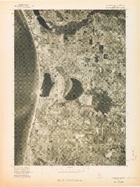
 1976 Frankfort NW1976 Print · USGSThe Lake Michigan shoreline and the deep basin of Crystal Lake are captured in this mid-seventies aerial study. Local historians can trace the harbor development at Frankfort and the smaller coastal settlement of Pilgrim.
 - 1976 Map of Frankfort SW
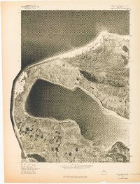
 1976 Frankfort SW1976 Print · USGSThe Benzie County shoreline appears in sharp detail during the mid-seventies in this aerial survey. Local historians can trace the exact footprint of coastal settlements like Elberta and Watervale alongside the waters of Betsie Lake.
 - 1976 Map of Thompsonville SW
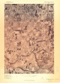
 1976 Thompsonville SW1976 Print · USGSNorthern Michigan's interior near the Benzie county line is seen in the mid-seventies through detailed aerial imagery. Trace the winding Betsie River as it passes near Thompsonville, Nessen City, and the rural settlement of Wallin.
 - 1976 Map of Thompsonville NW
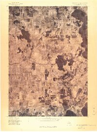
 1976 Thompsonville NW1976 Print · USGSCovers Benzie County, including Platte Township, Platte River, and other nearby areas
 - 1976 Map of Thompsonville SE
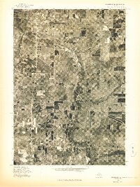
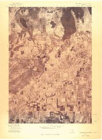 1976 Thompsonville SE1976 Print · USGSGrand Traverse County is seen here during the mid-seventies, captured in a detailed aerial orthophoto that reveals the precise layout of the landscape. Researchers can trace the path of the Betsie River and locate the small settlement of Karlin.
 - 1976 Map of Frankfort NE
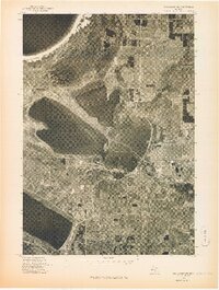 1976 Frankfort NE1976 Print · USGSBenzie County’s lake-studded shoreline is captured in this mid-seventies aerial survey of the Lake Michigan coast. Genealogists and local researchers can trace the mid-century footprints of Honor and Beulah and see the 1976 property patterns around Platte Lake.
End of results
Showing maps 1-8 of 8
Top cities of Benzie County
Frequently asked questions
- What are the different types of historical maps available for Benzie County?
- What is the oldest map of Benzie County?
- Where can I purchase historical maps of Benzie County for my home or office?
- Where can I download high-res historical maps of Benzie County?
- Are there historical topographic maps available for Benzie County?
- Is there historical aerial imagery available for Benzie County?
- Where are historical maps of Benzie County sourced from?