1980s Maps of Benzie County, Michigan
Explore 14 historic maps of Benzie County from the 1980s. These maps offer a rare glimpse into what life looked like during the 1980s — showing old roads, neighborhoods, homes, and landmarks that have changed or disappeared over time.
Whether you're researching your family's past, planning a metal detecting trip, or studying how Benzie County's landscape evolved across the 1980s, these high-resolution maps are a powerful tool for exploring the history of this region.
- Focus on a specific era: All maps on this page are from the 1980s, giving you a focused view of this time period.
- See what’s changed: Compare century-old streets, trails, and buildings to today's modern landscape using overlays and satellite layers.
- Research with precision: Use these maps for genealogy, historical research, land use analysis, or educational projects.
- View, download, or print: Maps are fully viewable online in high resolution, and can be downloaded or printed for your own records.
Start exploring Benzie County's history through authentic maps from the 1980s. This is your window into the past.
Benzie County, MI maps
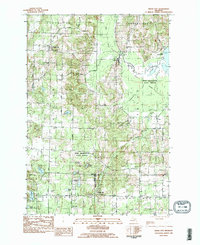
(14)- 1983 Map of Beulah, 1984 Print
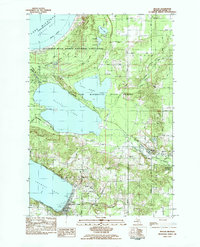 1983 Beulah1984 Print · USGSBenzie County’s lake-studded landscape is captured here in the early eighties, from the dunes of Platte Bay to the village of Beulah. Genealogists and historians can trace the Ann Arbor RR line, locate the Platte River Sch, and find family landmarks like Marshall Road.
 - 1983 Map of Empire, 1984 Print
 1983 Empire1984 Print · USGSThe Leelanau shoreline comes into focus in the early eighties as the national lakeshore took its modern shape. Researchers can trace local landmarks like Maple Grove Cem and the Radar Station or follow the path of Otter Creek through the dunes.2 unique versions available
 - 1983 Map of Thompsonville, 1984 Print
 1983 Thompsonville1984 Print · USGSBenzie and Manistee counties meet in the early eighties at the junction of the Betsie River and the Pere Marquette State Forest. Genealogists and local historians can trace the rural communities of Thompsonville, Nessen City, and Wallin, along with family sites near Homestead Cem.
 - 1983 Map of Burdickville, 1984 Print
 1983 Burdickville1984 Print · USGSLeelanau County's lake-rich landscape is captured here in the early eighties, centered on the community of Burdickville and the southern shores of Glen Lake. Researchers can trace rural cemeteries like Tobin Cem and Wilson Cem, alongside local landmarks like Glen Lake Sch.3 unique versions available
 - 1983 Map of Maple City, 1984 Print
 1983 Maple City1984 Print · USGSLeelanau County's rural heartland is captured here in the early eighties, showcasing a landscape of dense state forests and scattered farmsteads. Genealogists can trace family names through numerous sites like St Rita Cem, Kasson Cem, and the settlement at Maple City.2 unique versions available
 - 1983 Map of Benzonia, 1984 Print
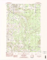 1983 Benzonia1984 Print · USGSBenzie County’s rural interior is captured here in the early eighties, showing the agricultural grids and river valleys south of Crystal Lake. Genealogists can locate family landmarks like Joyfield Cem or trace the path of the Betsie River and the Northern Michigan rail line.2 unique versions available
 - 1983 Map of Frankfort, 1984 Print
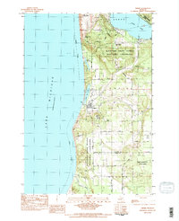
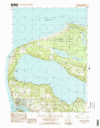 1983 Frankfort1984 Print · USGSCoastal Benzie County in the early eighties shows the harbor towns of Frankfort and Elberta alongside a network of inland lakes. Researchers can trace the path of the Ann Arbor RR and locate local sites like Crystal Lake Cem and Point Betsie Lighthouse.2 unique versions available
 - 1983 Map of Platte River, 1984 Print
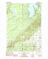
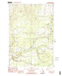 1983 Platte River1984 Print · USGSBenzie County’s interior lakes and forests appear in detail during the early eighties, centered on the Platte River. Genealogists and local historians can locate Almira Ch, Brundage Cem, and the old site of Clarks Mill among the timberlands.2 unique versions available
 - 1983 Map of Traverse City, 1984 Print
 1983 Traverse City1984 Print · USGSTraverse City and the surrounding bay country are captured in the early eighties as the region balanced its timber heritage with growing conservation. Genealogists and local historians can trace the rail lines of the Ann Arbor RR through settlements like Kingsley and Fife Lake.2 unique versions available
 - 1983 Map of Karlin, 1984 Print
 1983 Karlin1984 Print · USGSNorthern Michigan’s forest and lake country is captured here during the early eighties, showcasing the intersection of four counties. You can trace family history at Karlin or locate rural landmarks like the De Lorme Cem, Grant Ch, and Pavlovic Corner.2 unique versions available
 - 1983 Map of Lake Ann, 1984 Print
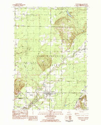
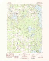 1983 Lake Ann1984 Print · USGSBenzie and Grand Traverse counties appear here in the early 1980s, showcasing a landscape defined by glacial lakes and state forests. Researchers can trace local lineage through Lake Ann Cem and Inland Corners or explore the grounds of the Interlochen Center for the Arts.2 unique versions available
 - 1983 Map of Elberta, 1984 Print
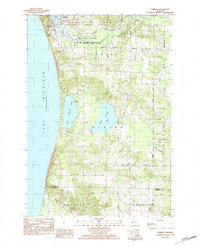 1983 Elberta1984 Print · USGSThe Lake Michigan shoreline of Benzie County is shown in detail during the early 1980s, from the harbor at Elberta to the dunes of Arcadia. Genealogists and local historians can locate early burial sites like Gilmore Cem and rural gathering places such as Putney Corners and Blaine Ch.
 - 1984 Map of Crystal Lake, 1985 Print
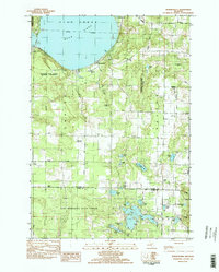
 1984 Crystal Lake1985 Print · USGSCoastal Benzie County in the mid-1980s reveals a landscape shaped by shifting dunes and deep glacial lakes. Researchers can trace the development of lakeside towns like Frankfort and Elberta, or locate landmarks such as the Point Betsie Lighthouse.2 unique versions available
 - 1989 Map of Traverse City, 1990 Print
 1989 Traverse City1990 Print · USGSNorthern Michigan’s lake-country and forest lands are captured in the late eighties as seasonal tourism and timber hubs expanded. Genealogists and historians can trace the routes of the Ann Arbor RR, the boundaries of Camp Grayling, and settlements like Elk Rapids and Manton.
End of results
Showing maps 1-14 of 14
Top cities of Benzie County
Frequently asked questions
- What are the different types of historical maps available for Benzie County?
- What is the oldest map of Benzie County?
- Where can I purchase historical maps of Benzie County for my home or office?
- Where can I download high-res historical maps of Benzie County?
- Are there historical topographic maps available for Benzie County?
- Is there historical aerial imagery available for Benzie County?
- Where are historical maps of Benzie County sourced from?