1970s Maps of Inland Township, Michigan
Explore 4 historic maps of Inland Township from the 1970s. These maps offer a rare glimpse into what life looked like during the 1970s — showing old roads, neighborhoods, homes, and landmarks that have changed or disappeared over time.
Whether you're researching your family's past, planning a metal detecting trip, or studying how Inland Township's landscape evolved across the 1970s, these high-resolution maps are a powerful tool for exploring the history of this region.
- Focus on a specific era: All maps on this page are from the 1970s, giving you a focused view of this time period.
- See what’s changed: Compare century-old streets, trails, and buildings to today's modern landscape using overlays and satellite layers.
- Research with precision: Use these maps for genealogy, historical research, land use analysis, or educational projects.
- View, download, or print: Maps are fully viewable online in high resolution, and can be downloaded or printed for your own records.
Start exploring Inland Township's history through authentic maps from the 1970s. This is your window into the past.
Inland Township, MI maps
(4)- 1976 Map of Thompsonville NE
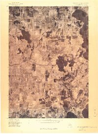 1976 Thompsonville NE1976 Print · USGSGrand Traverse County's lake-studded landscape is captured in this mid-1970s aerial survey just as these lakeside communities were evolving. You can trace the rural layouts of Lake Ann and Bendon or examine the shorelines of Long Lake and Green Lake.
 - 1976 Map of Thompsonville SW
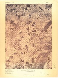 1976 Thompsonville SW1976 Print · USGSNorthern Michigan's interior near the Benzie county line is seen in the mid-seventies through detailed aerial imagery. Trace the winding Betsie River as it passes near Thompsonville, Nessen City, and the rural settlement of Wallin.
 - 1976 Map of Thompsonville NW
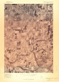 1976 Thompsonville NW1976 Print · USGSCovers Inland Township, including Platte Township, Platte River, and other nearby areas
 - 1976 Map of Thompsonville SE
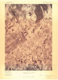 1976 Thompsonville SE1976 Print · USGSGrand Traverse County is seen here during the mid-seventies, captured in a detailed aerial orthophoto that reveals the precise layout of the landscape. Researchers can trace the path of the Betsie River and locate the small settlement of Karlin.
End of results
Showing maps 1-4 of 4
Top cities near Inland Township
- Garfield Township historical maps
- Traverse City historical maps
- Long Lake Charter Township historical maps
- Long Lake Township historical maps
- Blair Township historical maps
- Green Lake Township historical maps
See more
Top neighborhoods of Inland Township
Frequently asked questions
- What are the different types of historical maps available for Inland Township?
- What is the oldest map of Inland Township?
- Where can I purchase historical maps of Inland Township for my home or office?
- Where can I download high-res historical maps of Inland Township?
- Are there historical topographic maps available for Inland Township?
- Is there historical aerial imagery available for Inland Township?
- Where are historical maps of Inland Township sourced from?