1930s Maps of Weesaw Township, Michigan
Explore 2 historic maps of Weesaw Township from the 1930s. These maps offer a rare glimpse into what life looked like during the 1930s — showing old roads, neighborhoods, homes, and landmarks that have changed or disappeared over time.
Whether you're researching your family's past, planning a metal detecting trip, or studying how Weesaw Township's landscape evolved across the 1930s, these high-resolution maps are a powerful tool for exploring the history of this region.
- Focus on a specific era: All maps on this page are from the 1930s, giving you a focused view of this time period.
- See what’s changed: Compare century-old streets, trails, and buildings to today's modern landscape using overlays and satellite layers.
- Research with precision: Use these maps for genealogy, historical research, land use analysis, or educational projects.
- View, download, or print: Maps are fully viewable online in high resolution, and can be downloaded or printed for your own records.
Start exploring Weesaw Township's history through authentic maps from the 1930s. This is your window into the past.
Weesaw Township, MI maps
(2)- 1930 Map of Three Oaks
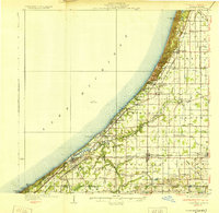 1930 Three Oaks1930 Print · USGSSouthwest Michigan's lakeshore and interior townships are captured in detail during the late twenties. Genealogists and historians can trace family roots through numerous rural schoolhouses like California Sch or visit the settled blocks of Three Oaks and New Buffalo.3 unique versions available
 - 1930 Map of Niles
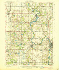 1930 Niles1930 Print · USGSBerrien County's rural heartland is captured here at the onset of the 1930s, showing the agricultural and riverine landscape before modern development. Genealogists can trace family roots through numerous country schools like Bedinger Sch and landmark sites such as Salem Ch or Pennellwood.4 unique versions available
End of results
Showing maps 1-2 of 2
Top cities near Weesaw Township
- South Bend historical maps
- La Porte historical maps
- Saint Joseph historical maps
- Olive historical maps
- Buchanan historical maps
- Bridgman historical maps
See more
Top neighborhoods of Weesaw Township
Frequently asked questions
- What are the different types of historical maps available for Weesaw Township?
- What is the oldest map of Weesaw Township?
- Where can I purchase historical maps of Weesaw Township for my home or office?
- Where can I download high-res historical maps of Weesaw Township?
- Are there historical topographic maps available for Weesaw Township?
- Is there historical aerial imagery available for Weesaw Township?
- Where are historical maps of Weesaw Township sourced from?