1940s Maps of Chippewa County, Michigan
Explore 4 historic maps of Chippewa County from the 1940s. These maps offer a rare glimpse into what life looked like during the 1940s — showing old roads, neighborhoods, homes, and landmarks that have changed or disappeared over time.
Whether you're researching your family's past, planning a metal detecting trip, or studying how Chippewa County's landscape evolved across the 1940s, these high-resolution maps are a powerful tool for exploring the history of this region.
- Focus on a specific era: All maps on this page are from the 1940s, giving you a focused view of this time period.
- See what’s changed: Compare century-old streets, trails, and buildings to today's modern landscape using overlays and satellite layers.
- Research with precision: Use these maps for genealogy, historical research, land use analysis, or educational projects.
- View, download, or print: Maps are fully viewable online in high resolution, and can be downloaded or printed for your own records.
Start exploring Chippewa County's history through authentic maps from the 1940s. This is your window into the past.
Chippewa County, MI maps
(4)- 1941 Map of Neebish
 1941 Neebish1941 Print · USGSChippewa County island life and maritime traffic are captured here in the early 1940s, showing the vital shipping channels along the Canadian border. Genealogists can trace the rural community through landmarks like the Neebish Ferry, Homestead, and the Stone School.
 - 1941 Map of Sault Sainte Marie
 1941 Sault Sainte Marie1941 Print · USGSUpper Peninsula life centered on the locks and river during the early years of the war. Genealogists and historians can trace family-named schools and rural landmarks from Algonquin down to the Parkerville Church and Dafter.
 - 1941 Map of Strongs, 1947 Print
 1941 Strongs1947 Print · USGSChippewa County in the early 1940s centers on the rail-side life of Strongs and the northern shore of Pendills Bay. Researchers can locate vanished landmarks like the Jones School, the Demond Hill Fire Tower, and the early layout of Raco Field.
 - 1941 Map of Brimley, 1947 Print
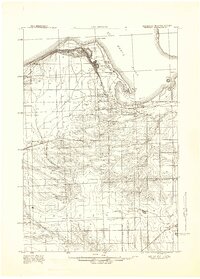 1941 Brimley1947 Print · USGSThe Lake Superior shoreline and St. Marys River come alive in this wartime-era survey of the Upper Peninsula. Genealogists can trace family roots at the Finnish Church or locate vanished school sites like the Maple Grove School and Dorgan School.
End of results
Showing maps 1-4 of 4
Top cities of Chippewa County
Frequently asked questions
- What are the different types of historical maps available for Chippewa County?
- What is the oldest map of Chippewa County?
- Where can I purchase historical maps of Chippewa County for my home or office?
- Where can I download high-res historical maps of Chippewa County?
- Are there historical topographic maps available for Chippewa County?
- Is there historical aerial imagery available for Chippewa County?
- Where are historical maps of Chippewa County sourced from?