1960s Maps of Chippewa County, Michigan
Explore 20 historic maps of Chippewa County from the 1960s. These maps offer a rare glimpse into what life looked like during the 1960s — showing old roads, neighborhoods, homes, and landmarks that have changed or disappeared over time.
Whether you're researching your family's past, planning a metal detecting trip, or studying how Chippewa County's landscape evolved across the 1960s, these high-resolution maps are a powerful tool for exploring the history of this region.
- Focus on a specific era: All maps on this page are from the 1960s, giving you a focused view of this time period.
- See what’s changed: Compare century-old streets, trails, and buildings to today's modern landscape using overlays and satellite layers.
- Research with precision: Use these maps for genealogy, historical research, land use analysis, or educational projects.
- View, download, or print: Maps are fully viewable online in high resolution, and can be downloaded or printed for your own records.
Start exploring Chippewa County's history through authentic maps from the 1960s. This is your window into the past.
Chippewa County, MI maps
(20)- 1961 Map of Blind River, 1966 Print
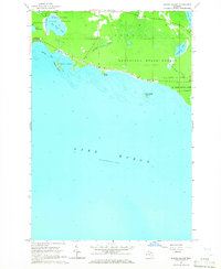
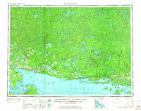 1961 Blind River1966 Print · USGSThe North Channel and Ontario shoreline are captured here in the early sixties, showing the vital link between coastal ports and the rugged interior. Trace the Canadian Pacific rail line through Thessalon and Massey, or locate landings on Drummond Island.3 unique versions available
 - 1964 Map of De Tour Village, 1965 Print
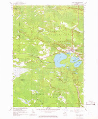
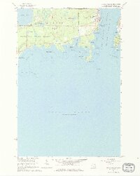 1964 De Tour Village1965 Print · USGSDe Tour Village and the Saint Marys River shoreline are captured here in the mid-1960s, showing the town's critical role in Great Lakes navigation. Genealogists and maritime historians can locate De Tour Lighthouse, Bob Hill Cem, and the old quarry near the water's edge.2 unique versions available
 - 1964 Map of Ozark, 1965 Print
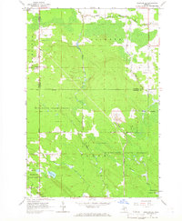
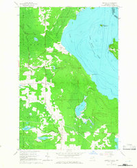
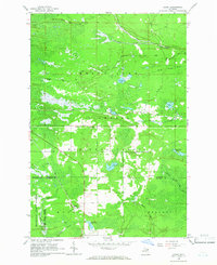 1964 Ozark1965 Print · USGSThe Upper Peninsula wilderness of Chippewa and Mackinac Counties is captured here in the mid-1960s as a landscape of timber and rail. Genealogists and local historians can locate the community of Ozark, the Brethren Cem, and landmarks like the Trout Lake Lookout Tower.3 unique versions available
 - 1964 Map of Marble Head, 1965 Print
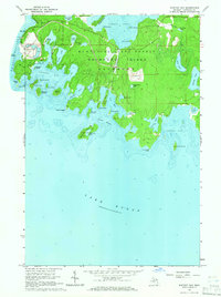
 1964 Marble Head1965 Print · USGSDrummond Island and its easternmost point at Marble Head are captured here during the mid-1960s, a period defined by forestry and remote coastal living. Researchers can trace the layout of Johnswood, follow trails through Munuscong State Forest, and locate landmarks like Shelter Island and the Gravel Pit.3 unique versions available
 - 1964 Map of Albany Island, 1965 Print
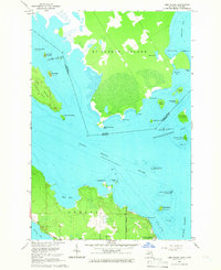
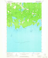
 1964 Albany Island1965 Print · USGSThe eastern Upper Peninsula shoreline meets the waters of Lake Huron in this mid-1960s survey of Chippewa County. Trace the wild coastal terrain of Munuscong State Forest and the protected waters of Albany Harbor and Big Trout Lake.3 unique versions available
 - 1964 Map of Stalwart, 1965 Print
 1964 Stalwart1965 Print · USGSThe eastern Upper Peninsula is shown in the mid-1960s, documenting the rural community of Stalwart and the surrounding wilderness. Genealogists and historians can locate the Stalwart Cem and Fairground, or trace family-named waters like McAdams Lake and Sam Taylor Lake.
 - 1964 Map of Prentiss Bay, 1965 Print
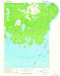
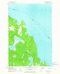
 1964 Prentiss Bay1965 Print · USGSThe northern shores of Lake Huron appear in detail during the mid-1960s, showing the intersection of Mackinac and Chippewa counties. Genealogists and maritime historians can trace coastal features like Cedar Campus Camp, the Light at Martin Reef, and the many inlets of Prentiss Bay.2 unique versions available
 - 1964 Map of Drummond, 1965 Print
 1964 Drummond1965 Print · USGSDrummond Island and the surrounding archipelago are captured at the international boundary in the mid-1960s. Researchers can locate the Drummond post office, the Indian Cem, and the Maxton Lookout Tower overlooking the bay.3 unique versions available
 - 1964 Map of Ozark NE, 1965 Print
 1964 Ozark NE1965 Print · USGSUpper Peninsula timberlands and rail stops are captured here in the mid-1960s as the Soo Line crosses the wilderness. Genealogists and historians can trace small settlements like Cordell or find landmarks like the Lookout Tower on Maple Hill.2 unique versions available
 - 1964 Map of Whitney Bay, 1965 Print
 1964 Whitney Bay1965 Print · USGSDrummond Island's rugged southern shore appears here in the mid-sixties, a landscape of state forest and historic military outposts. Researchers can trace the grounds of Old Fort Drummond, find a hidden Cem, or locate the expansive Quarry near Kempainen Lake.3 unique versions available
 - 1964 Map of Pickford SE, 1966 Print
 1964 Pickford SE1966 Print · USGSUpper Peninsula timber and quarrying operations are detailed in this mid-sixties survey of the Mackinac County interior. Genealogists and researchers can locate family sites at Cedarville, the Bethel Ch, and the isolated Hannah Cem along the Industrial Railroad.2 unique versions available
 - 1964 Map of Lime Island, 1966 Print
 1964 Lime Island1966 Print · USGSThe maritime borderlands between Michigan and Ontario come into focus in the mid-1960s. Researchers can trace the shoreline of De Tour Village and find local landmarks like Sacred Heart Cem and Lime Island.2 unique versions available
 - 1964 Map of Rexton, 1966 Print
 1964 Rexton1966 Print · USGSThe Upper Peninsula’s timber and mining heritage is on display in this mid-century survey of Mackinac County. Researchers can trace the legacy of the Fiborn Quarry and the Soo Line railroad near Rexton and the Caffey Cem.2 unique versions available
 - 1964 Map of Trout Lake, 1966 Print
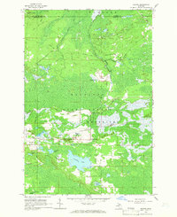
 1964 Trout Lake1966 Print · USGSTrout Lake emerged as a vital Upper Peninsula rail hub in the mid-twentieth century, surrounded by the deep woods of the Hiawatha and Mackinac State Forests. Researchers can trace the original Soo Line rail corridors, the historic Lakeview Cem, and local landmarks like School No 15.2 unique versions available
 - 1964 Map of Goetzville, 1966 Print
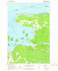
 1964 Goetzville1966 Print · USGSThe Saint Marys River shoreline and the international border with Ontario are mapped here during the mid-sixties. Researchers can locate the Township Sch, St Stanislaus Ch, and the Old Railroad Grade running through the Gogomain Swamp.2 unique versions available
 - 1964 Map of Meade Island, 1966 Print
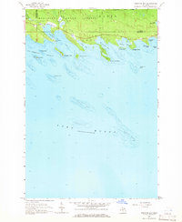
 1964 Meade Island1966 Print · USGSThe northern reaches of Lake Huron and the forests of Drummond Island are captured here in the mid-1960s. Genealogists and local historians can locate the Finnish Cem and the settlement of Lincoln or trace the shoreline from Canoe Point to Scammon Point.2 unique versions available
 - 1964 Map of Drummond SE, 1966 Print
 1964 Drummond SE1966 Print · USGSDrummond Island’s southeastern wilderness is captured here in the mid-1960s, showing the intersection of Michigan and Ontario in the North Channel. Researchers can trace the winding Potagannissing River through the Munuscong State Forest and across the Maxton Plains.3 unique versions available
 - 1964 Map of Burnt Island, 1966 Print
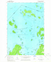 1964 Burnt Island1966 Print · USGSDrummond Island and its surrounding archipelago are captured in the mid-sixties, showing the intricate waterways of the North Channel. Maritime researchers can trace the shoreline of Potagannissing Bay and find coastal features like the Quarry and Wreck Island.3 unique versions available
 - 1968 Map of Blind River
 1968 Blind River1968 Print · USGSThe North Channel coast and the North Woods of Ontario and Michigan are captured here in the late sixties. Genealogists and local historians can trace the Canadian Pacific rail line through Bruce Station, Thessalon, and Blind River.
 - 1969 Map of Alpena
 1969 Alpena1969 Print · USGSThe Lake Huron coastline and the Manitoulin islands come alive in this mid-century survey of the Michigan-Ontario border. Genealogists and historians can trace the Detroit and Mackinac rail line through settlements like Lachine and Cathro, or locate the numerous island reservations including Obigewong Indian Reservation No 21.
End of results
Showing maps 1-20 of 20
Top cities of Chippewa County
Frequently asked questions
- What are the different types of historical maps available for Chippewa County?
- What is the oldest map of Chippewa County?
- Where can I purchase historical maps of Chippewa County for my home or office?
- Where can I download high-res historical maps of Chippewa County?
- Are there historical topographic maps available for Chippewa County?
- Is there historical aerial imagery available for Chippewa County?
- Where are historical maps of Chippewa County sourced from?