1950s Maps of Chippewa County, Michigan
Explore 47 historic maps of Chippewa County from the 1950s. These maps offer a rare glimpse into what life looked like during the 1950s — showing old roads, neighborhoods, homes, and landmarks that have changed or disappeared over time.
Whether you're researching your family's past, planning a metal detecting trip, or studying how Chippewa County's landscape evolved across the 1950s, these high-resolution maps are a powerful tool for exploring the history of this region.
- Focus on a specific era: All maps on this page are from the 1950s, giving you a focused view of this time period.
- See what’s changed: Compare century-old streets, trails, and buildings to today's modern landscape using overlays and satellite layers.
- Research with precision: Use these maps for genealogy, historical research, land use analysis, or educational projects.
- View, download, or print: Maps are fully viewable online in high resolution, and can be downloaded or printed for your own records.
Start exploring Chippewa County's history through authentic maps from the 1950s. This is your window into the past.
Chippewa County, MI maps
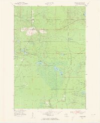
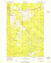
(47)- 1951 Map of Vermilion SE
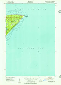
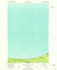 1951 Vermilion SE1951 Print · USGSThe southern shore of Lake Superior in the early 1950s reveals a wild landscape of coastal wetlands and state timberlands. Researchers can trace the intricate shorelines of Weatherhogs Lake, the Cranberry Bogs, and the Whitefish Lake Superior State Forest.2 unique versions available
 - 1951 Map of Shallows
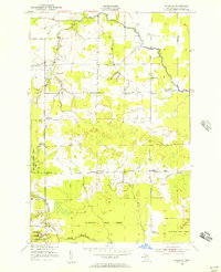
 1951 Shallows1951 Print · USGSThe Upper Peninsula shoreline south of the Canadian border was a landscape of dense state forests and emerging rail hubs in the early fifties. Local historians can trace the foundations of Sault Ste Marie and rural landmarks like the County Farm and Pine Grove Cem.3 unique versions available
 - 1951 Map of Shelldrake, 1955 Print
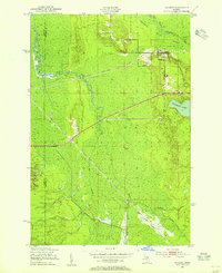
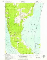
 1951 Shelldrake1955 Print · USGSThe Michigan shoreline of Whitefish Bay comes alive in this early 1950s record of Chippewa County's timberlands. Researchers can trace the coastal outposts of Shelldrake and Paradise or follow the intricate windings of the Betsy River through the state forest.2 unique versions available
 - 1951 Map of Vermilion, 1955 Print
 1951 Vermilion1955 Print · USGSThe Lake Superior shoreline near the Chippewa and Luce county line is captured in the early fifties, showing the isolated coastal settlement of Vermilion. Researchers can trace the wooded boundaries of the Whitefish State Forest and locate Browns Lake or the landmark Tower near the coast.2 unique versions available
 - 1951 Map of Strongs, 1955 Print
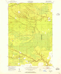
 1951 Strongs1955 Print · USGSStrongs and its surrounding forest lands are documented here in the early fifties during the height of the local rail era. Genealogists can locate Colbert Cem, Jones Sch, and the Community Ch along the historic Duluth South Shore and Atlantic line.4 unique versions available
 - 1951 Map of McNearney Lake, 1955 Print
 1951 McNearney Lake1955 Print · USGSUpper Peninsula shoreline meets the deep woods in the early fifties, showing the coastal transition from bay to forest. Researchers can trace the path of Lake Shore Drive or locate landmarks like the McNearney Lake Tower and Naomikong Island.3 unique versions available
 - 1951 Map of Pendills Lake, 1955 Print
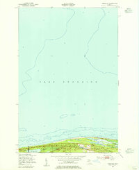
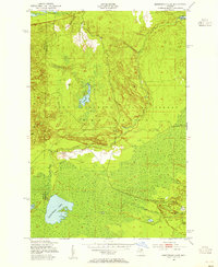
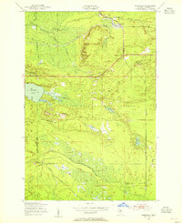
 1951 Pendills Lake1955 Print · USGSThe Lake Superior coastline in Chippewa County shows its mid-century recreational and forest service character during the early 1950s. Researchers can trace the development of the Marquette National Forest and locate public sites like Bayview Camp Grounds and Pendills Lake.2 unique versions available
 - 1951 Map of Sheephead Lake, 1955 Print
 1951 Sheephead Lake1955 Print · USGSNorthern Michigan's forest and wetland interior are documented in the early fifties during a period of state-managed land use. Trace remote sites like the Prison Camp, the Porcupine Inn, and the waters of Sheephead Lake.2 unique versions available
 - 1951 Map of Emerson, 1955 Print
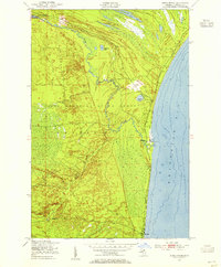
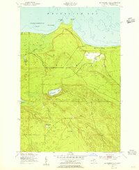
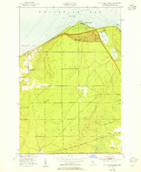
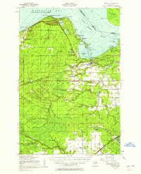
 1951 Emerson1955 Print · USGSCoastal life in Chippewa County flourished along the shores of Whitefish Bay in the early 1950s. Genealogists and historians can trace the foundations of Paradise and Emerson, finding local landmarks such as the Whitefish Sch and Hiawatha Hunt Club.2 unique versions available
 - 1951 Map of Piatt Lake, 1955 Print
 1951 Piatt Lake1955 Print · USGSUpper Peninsula timberlands and the Lake Superior coast are captured here in the early fifties. Local historians can trace the forestry network around Eckerman Lookout Tower or locate the shoreline camps near Tahquamenon Bay and Piatt Lake.3 unique versions available
 - 1951 Map of Dollar Settlement, 1955 Print
 1951 Dollar Settlement1955 Print · USGSCoastal life in the Upper Peninsula was defined by timber and the Lake Superior shoreline during the early fifties. Genealogists and local historians can trace the Dollar Settlement community, including the Dollar Settlement Sch, and the railway stop at Raco.2 unique versions available
 - 1951 Map of Big Beaver Creek, 1955 Print
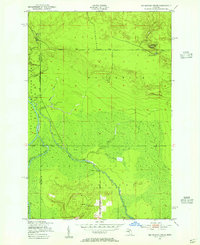 1951 Big Beaver Creek1955 Print · USGSUpper Peninsula timberlands and river systems are captured in the early fifties at the junction of three forests. Researchers can trace the logging history of the region via Cadillac Soo Camp 14, Buckhorn Lodge, and a Sawmill.3 unique versions available
 - 1951 Map of Sullivan Creek, 1955 Print
 1951 Sullivan Creek1955 Print · USGSThe Upper Peninsula wilderness in the early fifties shows a landscape of strategic airfields and deep-woods retreats. You can trace the path of the Duluth South Shore and Atlantic rail line or locate remote camps like Ol Misery Lodge and Camp Quiet.3 unique versions available
 - 1951 Map of Hulbert, 1955 Print
 1951 Hulbert1955 Print · USGSChippewa County timberlands and river systems are shown here in the early fifties, centered on the village of Hulbert. Trace the path of the Duluth South Shore and Atlantic railroad or locate Hulbert Cem and The Antlers Cabins near the lake.3 unique versions available
 - 1951 Map of Raco, 1955 Print
 1951 Raco1955 Print · USGSUpper Peninsula timberlands and forest stations dominate this mid-century survey of Chippewa County. Local historians can trace the Duluth South Shore and Atlantic rail line and locate landmarks like Squirrel Tail Inn, Camp Dearborn, and Raco.3 unique versions available
 - 1951 Map of Eckerman, 1955 Print
 1951 Eckerman1955 Print · USGSUpper Peninsula timberlands and hunting grounds are captured here in the early fifties, centered on the rail junction at Eckerman. Genealogists and local historians can locate private camps like Petersburg Club, the O Conner Airstrip, and the Eckerman Corner Lookout Tower.2 unique versions available
 - 1951 Map of Whitefish Point, 1955 Print
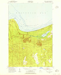
 1951 Whitefish Point1955 Print · USGSWhitefish Point at the start of the 1950s remained a critical outpost for Great Lakes mariners. Researchers can trace the coastal layout of the USCG Radio Sta and Fog Warning Sta and the early path of Whitefish Road through the Lake Superior State Forest.2 unique versions available
 - 1951 Map of Timberlost, 1955 Print
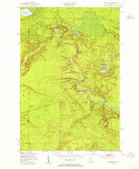 1951 Timberlost1955 Print · USGSThe Upper Peninsula wilderness of the early fifties is defined here by the winding river and the early boundaries of Tahquamenon Falls State Park. Genealogists and local historians can trace isolated settlements and riverside outposts like Timberlost, Whitehorse Landing, and Bowers Lodge.4 unique versions available
 - 1951 Map of Kinross, 1956 Print
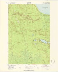
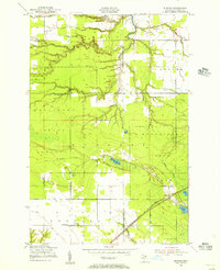 1951 Kinross1956 Print · USGSChippewa County’s timbered landscape and rural crossroads appear here in the early fifties as the railroad connected local settlements to the Soo. Trace family history at Rudyard Cem or explore the historic footprint of Kinross and the Holland Sch.2 unique versions available
 - 1951 Map of Dafter, 1956 Print
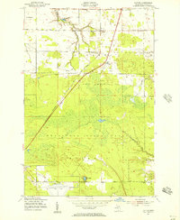 1951 Dafter1956 Print · USGSUpper Peninsula wetlands and timberlands are captured here in the early fifties as the region's transport network matured. Genealogists and researchers can pinpoint rural landmarks like the Methodist Ch, Christie Sch, and the grounds of the 4 H Club Camp.2 unique versions available
 - 1951 Map of Barbeau, 1956 Print
 1951 Barbeau1956 Print · USGSUpper Peninsula life in the early fifties is documented here through the small schoolhouses and remote settlements of Bruce Township. Genealogists can trace family footprints near Donaldson Cem, McCarron Ch, or the rural Corktown Sch.3 unique versions available
 - 1951 Map of Baie De Wasai, 1956 Print
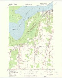
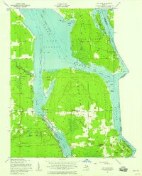
 1951 Baie De Wasai1956 Print · USGSSugar Island's interior and shoreline communities are captured here in the early fifties as the river shipping lanes remained vital to the region. Genealogists can locate family landmarks like Sacred Heart Ch, Edison Sch, and the Town Hall at Baie de Wasai.2 unique versions available
 - 1951 Map of Brimley, 1958 Print
 1951 Brimley1958 Print · USGSThe Upper Peninsula shoreline and interior forests are captured here in the early fifties, showing the tribal lands and rail towns of the Whitefish Bay region. Genealogists can trace family locations at Dollar Settlement, St Catherines Ch, and Rudyard Cem.2 unique versions available
 - 1951 Map of Oak Ridge, 1958 Print
 1951 Oak Ridge1958 Print · USGSThe shipping channels and island communities of the Saint Marys River are captured here in the early fifties. Genealogists and maritime historians can trace the borderlands of Neebish Island and Sugar Island, locating the Oak Ridge Park Sch and the settlement of Homestead.2 unique versions available
 - 1951 Map of Sault Ste. Marie, 1958 Print
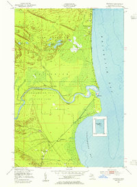
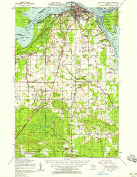 1951 Sault Ste. Marie1958 Print · USGSSault Ste. Marie and the eastern Upper Peninsula are seen here at the dawn of the 1950s, showing the vital shipping arteries and borderlands. Researchers can locate numerous vanished rural schoolhouses like Green Sch Aband and trace the original Michigan 129 through Barbeau and Rosedale.2 unique versions available
Showing maps 1-25 of 47
Top cities of Chippewa County
Frequently asked questions
- What are the different types of historical maps available for Chippewa County?
- What is the oldest map of Chippewa County?
- Where can I purchase historical maps of Chippewa County for my home or office?
- Where can I download high-res historical maps of Chippewa County?
- Are there historical topographic maps available for Chippewa County?
- Is there historical aerial imagery available for Chippewa County?
- Where are historical maps of Chippewa County sourced from?