
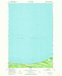
1951 Map of Vermilion SE
USGS Topo · Published 1951About this map
Whitefish Lake Superior State Forest dominates the southern edge of this coastal survey, where a complex network of wetlands and small inland waters meets the southern shore of Lake Superior. The landscape is defined by its transition from the deep soundings of the Great Lake to the low-lying interior, characterized by features such as Cranberry Bogs and the shallow Marsh Lakes. This 1951 field-checked map provides detailed hydrographic data from the U. S. Lake Survey, showing the underwater contours and soundings that were critical for navigation along this stretch of the Chippewa County coastline. Inland, the map records secluded water bodies including Weatherhogs Lake and Little Lake, offering a precise look at the drainage patterns and shoreline topography of the Upper Peninsula before significant modern development altered these remote forest environments.
Find a feature on this map
9 named features on this map. Tap any name to fly to it.
Don’t see what you’re looking for? This feature index may not catch every label — zoom into the map to look around manually.
Map Details
Editions of this 1951 Vermilion SE Map
2 editions found
Other maps of this area

1951 · Shelldrake
USGS Topo · 1:24,000

1951 · Vermilion
USGS Topo · 1:24,000

1951 · Sheephead Lake
USGS Topo · 1:24,000

1951 · Whitefish Point
USGS Topo · 1:24,000

1951 · Shelldrake
USGS Topo · 1:62,500

1954 · Sault Sainte Marie
USGS Topo · 1:250,000

1956 · Sault Sainte Marie
USGS Topo · 1:250,000

1957 · Sault Sainte Marie
USGS Topo · 1:250,000

1958 · Sault Sainte Marie
USGS Topo · 1:250,000
1985 · Two Hearted River
USGS Topo · 1:100,000