
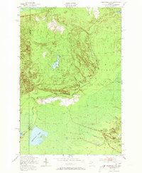
1951 Map of Sheephead Lake
USGS Topo · Published 1955About this map
Lake Superior State Forest covers this stretch of the Upper Peninsula, where the landscape transitions through the dense wetlands of the Whitefish region. Photogrammetric methods and 1950 aerial photography reveal a remote interior defined by the winding course of the Betsy River and its South Branch. The presence of the Prison Camp near the eastern margin and the Porcupine Inn along a forest trail suggests a specialized mid-century use of this northern wilderness, balancing state-managed labor and early seasonal recreation.
Find a feature on this map
13 named features on this map. Tap any name to fly to it.
Don’t see what you’re looking for? This feature index may not catch every label — zoom into the map to look around manually.
Map Details
Editions of this 1951 Sheephead Lake Map
2 editions found
Other maps of this area

1951 · Vermilion SE
USGS Topo · 1:24,000

1951 · Shelldrake
USGS Topo · 1:24,000

1951 · Vermilion
USGS Topo · 1:24,000

1951 · Emerson
USGS Topo · 1:24,000

1951 · Timberlost
USGS Topo · 1:24,000

1951 · Shelldrake
USGS Topo · 1:62,500

1954 · Sault Sainte Marie
USGS Topo · 1:250,000

1956 · Sault Sainte Marie
USGS Topo · 1:250,000

1957 · Sault Sainte Marie
USGS Topo · 1:250,000

1958 · Sault Sainte Marie
USGS Topo · 1:250,000