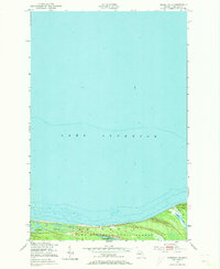
1951 Map of Vermilion SE
USGS Topo · Published 1955About this map
Lake Superior dominates the northern reaches of this coastal Michigan survey, where the vast expanse of the Great Lakes meets a shoreline defined by the Whitefish State Forest. The geography reveals a strip of low-lying terrain characterized by scattered inland water bodies, including the curiously named Weatherhogs Lake and the Marsh Lakes complex. The landscape suggests a remote, undeveloped stretch of the Upper Peninsula, largely preserved from industrial or residential density. The coastal hydrography, recorded in the early 1950s, indicates a rugged transition between the open water and the forested interior, with Little Lake tucked near the eastern boundary. This area represents a specific moment in mid-century conservation and land management in Chippewa County before more modern recreational development transformed the region.
Find a feature on this map
5 named features on this map. Tap any name to fly to it.
Don’t see what you’re looking for? This feature index may not catch every label — zoom into the map to look around manually.
Map Details
Editions of this 1951 Vermilion SE Map
2 editions found
Other maps of this area

1951 · Vermilion SE
USGS Topo · 1:24,000

1951 · Shelldrake
USGS Topo · 1:24,000

1951 · Vermilion
USGS Topo · 1:24,000

1951 · Sheephead Lake
USGS Topo · 1:24,000

1951 · Whitefish Point
USGS Topo · 1:24,000

1951 · Shelldrake
USGS Topo · 1:62,500

1954 · Sault Sainte Marie
USGS Topo · 1:250,000

1956 · Sault Sainte Marie
USGS Topo · 1:250,000

1957 · Sault Sainte Marie
USGS Topo · 1:250,000

1958 · Sault Sainte Marie
USGS Topo · 1:250,000