
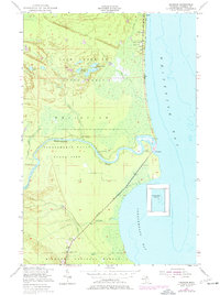
1951 Map of Emerson
USGS Topo · Published 1955About this map
The settlement at Paradise sits at the northern edge of this coastal survey, where local life centered around the Town Hall, an Athletic Field, and the Whitefish Sch. The shoreline of Whitefish Bay is dotted with community landmarks, including the Baptist Ch and Our Lady of Victory Ch, while the southern reaches follow the winding course of the Tahquamenon River.
Find a feature on this map
38 named features on this map. Tap any name to fly to it.
Don’t see what you’re looking for? This feature index may not catch every label — zoom into the map to look around manually.
Map Details
Editions of this 1951 Emerson Map
2 editions found
Other maps of this area

1941 · Strongs
USGS Topo · 1:63,360

1951 · Shelldrake
USGS Topo · 1:24,000

1951 · McNearney Lake
USGS Topo · 1:24,000

1951 · Sheephead Lake
USGS Topo · 1:24,000

1951 · Piatt Lake
USGS Topo · 1:24,000

1951 · Big Beaver Creek
USGS Topo · 1:24,000

1951 · Timberlost
USGS Topo · 1:24,000

1951 · Strongs
USGS Topo · 1:62,500

1951 · Eckerman
USGS Topo · 1:62,500

1951 · Shelldrake
USGS Topo · 1:62,500