Old Maps of Chippewa Township, Michigan for Genealogy
Trace your family roots with 45 historic maps of Chippewa Township. These high-res maps reveal old neighborhoods, homesites, landmarks, and streets — helping you uncover where your ancestors lived and how the area evolved over time.
- Explore historic neighborhoods: Identify where your relatives may have lived in the 1800s or 1900s.
- Compare maps over time: Trace the changes in streets, buildings, and landmarks for multi-generational research.
- Perfect for genealogy & ancestry research: Used by family historians and researchers to map out lineage and migration.
These maps are an incredible resource for exploring your personal connection to Chippewa Township's past.
Chippewa Township, MI maps
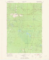
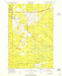
(45)- 1941 Map of Strongs, 1947 Print
 1941 Strongs1947 Print · USGSChippewa County in the early 1940s centers on the rail-side life of Strongs and the northern shore of Pendills Bay. Researchers can locate vanished landmarks like the Jones School, the Demond Hill Fire Tower, and the early layout of Raco Field.
 - 1951 Map of Strongs, 1955 Print
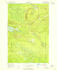
 1951 Strongs1955 Print · USGSStrongs and its surrounding forest lands are documented here in the early fifties during the height of the local rail era. Genealogists can locate Colbert Cem, Jones Sch, and the Community Ch along the historic Duluth South Shore and Atlantic line.4 unique versions available
 - 1951 Map of McNearney Lake, 1955 Print
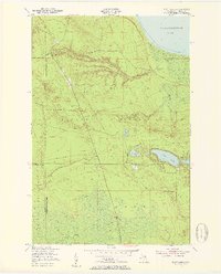
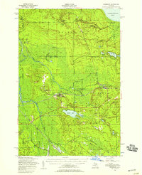
 1951 McNearney Lake1955 Print · USGSUpper Peninsula shoreline meets the deep woods in the early fifties, showing the coastal transition from bay to forest. Researchers can trace the path of Lake Shore Drive or locate landmarks like the McNearney Lake Tower and Naomikong Island.3 unique versions available
 - 1951 Map of Pendills Lake, 1955 Print
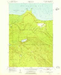
 1951 Pendills Lake1955 Print · USGSThe Lake Superior coastline in Chippewa County shows its mid-century recreational and forest service character during the early 1950s. Researchers can trace the development of the Marquette National Forest and locate public sites like Bayview Camp Grounds and Pendills Lake.2 unique versions available
 - 1951 Map of Piatt Lake, 1955 Print
 1951 Piatt Lake1955 Print · USGSUpper Peninsula timberlands and the Lake Superior coast are captured here in the early fifties. Local historians can trace the forestry network around Eckerman Lookout Tower or locate the shoreline camps near Tahquamenon Bay and Piatt Lake.3 unique versions available
 - 1951 Map of Sullivan Creek, 1955 Print
 1951 Sullivan Creek1955 Print · USGSThe Upper Peninsula wilderness in the early fifties shows a landscape of strategic airfields and deep-woods retreats. You can trace the path of the Duluth South Shore and Atlantic rail line or locate remote camps like Ol Misery Lodge and Camp Quiet.3 unique versions available
 - 1951 Map of Eckerman, 1955 Print
 1951 Eckerman1955 Print · USGSUpper Peninsula timberlands and hunting grounds are captured here in the early fifties, centered on the rail junction at Eckerman. Genealogists and local historians can locate private camps like Petersburg Club, the O Conner Airstrip, and the Eckerman Corner Lookout Tower.2 unique versions available
 - 1951 Map of Strongs, 1958 Print
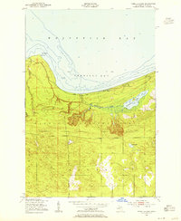
 1951 Strongs1958 Print · USGSCoastal Chippewa County is captured here in the early fifties, showing the interplay between Lake Superior's Whitefish Bay and the wooded interior. Genealogists and hikers can locate the Strong Sch, the Demond Hill Lookout Tower, and old camps like Mt. Misery Lodge.
 - 1951 Map of Eckerman, 1958 Print
 1951 Eckerman1958 Print · USGSIn the early 1950s, this portion of Chippewa County remained a landscape of remote sporting camps and timber interests tied to the rail line. Researchers can locate family landmarks like the Hulbert Cem, Eckerman Corner, and the Cadillac Soo Camp 14.2 unique versions available
 - 1954 Map of Sault Sainte Marie, 1979 Print
 1954 Sault Sainte Marie1979 Print · USGSThe Eastern Upper Peninsula and Ontario borderlands are captured here at the height of the mid-century era. Family historians can trace settlements like Grand Marais and Stalwart, while mapping the strategic grounds of Kincheloe AFB.3 unique versions available
 - 1956 Map of Sault Sainte Marie, 1964 Print
 1956 Sault Sainte Marie1964 Print · USGSThe Eastern Upper Peninsula and the Canadian border meet in this mid-sixties survey of the bustling Soo Locks region. Genealogists and historians can trace the paths of the Soo Line and locate lakeside communities from Grand Marais to Shelldrake.2 unique versions available
 - 1957 Map of Sault Sainte Marie
 1957 Sault Sainte Marie1957 Print · USGSThe Upper Peninsula and Ontario border come alive in this mid-century portrait of the eastern Lake Superior shoreline and the vital St. Marys River corridor. Genealogists and historians can trace rail-era settlements from Newberry to Detour, while locating military landmarks like Kinross Air Force Base.
 - 1958 Map of Sault Sainte Marie
 1958 Sault Sainte Marie1958 Print · USGSThe eastern Upper Peninsula and the Canadian borderland appear here during the late fifties, a time of military growth and forest management. Researchers can locate vanished rail stops along the Soo Line, early sites like the Fiborn Quarry, and the sprawling Kinross Air Force Base.
 - 1984 Map of Sault Ste. Marie South, 1985 Print
 1984 Sault Ste. Marie South1985 Print · USGSEastern Upper Peninsula life in the 1980s is captured here, from the northern forests down to the northern shores of Lake Huron. Researchers can locate small lakeside communities like Dollar Settlement, trace the Soo Line Railroad, and find family sites near Pine Grove Cem.2 unique versions available
 - 1985 Map of Manistique Lake
 1985 Manistique Lake1985 Print · USGSThe eastern Upper Peninsula’s wilderness and rail-side villages are captured here in the mid-1980s, from the Soo Line corridor to the Lake Michigan shore. Genealogists and historians can trace the foundations of local life in Newberry, Engadine, and Seney, alongside industrial landmarks like the Calspar Quarry Pool.2 unique versions available
 - 2011 Map of Eckerman, 2011 Print
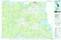
 2011 Eckerman2011 Print · USGSCovers Chippewa Township, including Eckerman, Eckerman Corner, and other nearby areas
 - 2011 Map of Piatt Lake, 2011 Print
 2011 Piatt Lake2011 Print · USGSCovers Chippewa Township, including Hulbert Township, Whitefish Township, and other nearby areas
 - 2011 Map of McNearney Lake, 2011 Print
 2011 McNearney Lake2011 Print · USGSCovers Chippewa Township, including Bay Mills Township, Whitefish Township, and other nearby areas
 - 2011 Map of Strongs, 2011 Print
 2011 Strongs2011 Print · USGSCovers Chippewa Township, including Kinross Township, Strongs Corner, and other nearby areas
 - 2011 Map of Sullivan Creek, 2011 Print
 2011 Sullivan Creek2011 Print · USGSCovers Chippewa Township, including Kinross Township, Superior Township, and other nearby areas
 - 2011 Map of Pendills Lake, 2011 Print
 2011 Pendills Lake2011 Print · USGSCovers Chippewa Township, including Bay Mills Township, Superior Township, and other nearby areas
 - 2014 Map of Strongs, 2014 Print
 2014 Strongs2014 Print · USGSCovers Chippewa Township, including Kinross Township, Strongs Corner, and other nearby areas
 - 2014 Map of Pendills Lake, 2014 Print
 2014 Pendills Lake2014 Print · USGSCovers Chippewa Township, including Bay Mills Township, Superior Township, and other nearby areas
 - 2014 Map of Sullivan Creek, 2014 Print
 2014 Sullivan Creek2014 Print · USGSCovers Chippewa Township, including Kinross Township, Superior Township, and other nearby areas
 - 2014 Map of McNearney Lake, 2014 Print
 2014 McNearney Lake2014 Print · USGSCovers Chippewa Township, including Bay Mills Township, Whitefish Township, and other nearby areas
Showing maps 1-25 of 45
Top cities near Chippewa Township
Top neighborhoods of Chippewa Township
- Strongs historical maps
- Eckerman historical maps
- Eckerman Corner historical maps
- Seewhy historical maps
- Strongs Corner historical maps
Frequently asked questions
- What are the different types of historical maps available for Chippewa Township?
- What is the oldest map of Chippewa Township?
- Where can I purchase historical maps of Chippewa Township for my home or office?
- Where can I download high-res historical maps of Chippewa Township?
- Are there historical topographic maps available for Chippewa Township?
- Is there historical aerial imagery available for Chippewa Township?
- Where are historical maps of Chippewa Township sourced from?