Old Maps of Maxton, Drummond Township for Metal Detecting
Plan your next treasure hunt with 9 historic maps of Maxton. Find old homesites, ghost towns, trails, and gathering spots that may be lost to time — perfect for identifying promising metal detecting locations.
- Locate forgotten sites: Uncover places like long-lost settlements, abandoned rail lines, or gathering spots.
- Plan better hunts: Use map overlays combined with LiDAR or satellite views to narrow in on historically rich areas.
- Made for detectorists: Thousands of hobbyists use these maps to discover relics, coins, and hidden history.
Use these historic maps to boost your research and find new opportunities beneath the surface of Maxton.
Maxton, Drummond Township maps
(9)- 1961 Map of Blind River, 1966 Print
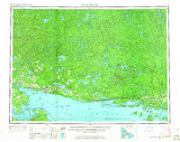 1961 Blind River1966 Print · USGSThe North Channel and Ontario shoreline are captured here in the early sixties, showing the vital link between coastal ports and the rugged interior. Trace the Canadian Pacific rail line through Thessalon and Massey, or locate landings on Drummond Island.3 unique versions available
 - 1964 Map of Drummond, 1965 Print
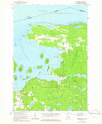 1964 Drummond1965 Print · USGSDrummond Island and the surrounding archipelago are captured at the international boundary in the mid-1960s. Researchers can locate the Drummond post office, the Indian Cem, and the Maxton Lookout Tower overlooking the bay.3 unique versions available
 - 1968 Map of Blind River
 1968 Blind River1968 Print · USGSThe North Channel coast and the North Woods of Ontario and Michigan are captured here in the late sixties. Genealogists and local historians can trace the Canadian Pacific rail line through Bruce Station, Thessalon, and Blind River.
 - 1984 Map of Drummond, 1985 Print
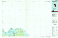 1984 Drummond1985 Print · USGSUpper Peninsula maritime life and the island geography of Chippewa County are captured here in the mid-eighties. Trace the roads through Maxton, locate the Quarry near the shore, or explore the inlets of Potagannissing Bay and Sturgeon Bay.2 unique versions available
 - 2011 Map of Drummond, 2011 Print
 2011 Drummond2011 Print · USGSCovers Maxton, including Huron Shores, Drummond, and other nearby areas
 - 2014 Map of Drummond, 2014 Print
 2014 Drummond2014 Print · USGSCovers Maxton, including Huron Shores, Drummond, and other nearby areas
 - 2017 Map of Drummond, 2017 Print
 2017 Drummond2017 Print · USGSCovers Maxton, including Huron Shores, Drummond, and other nearby areas
 - 2019 Map of Drummond, 2019 Print
 2019 Drummond2019 Print · USGSCovers Maxton, including Huron Shores, Drummond, and other nearby areas
 - 2023 Map of Drummond, 2023 Print
 2023 Drummond2023 Print · USGSDrummond Island at the northern edge of Lake Huron shows a unique borderland landscape defined by maritime activity and remote island life. Genealogists and historians can trace local family roots at Drummond Cem, Matthews Family Cem, and the grounds of Saint Florence Catholic Church.
End of results
Showing maps 1-9 of 9
Top cities near Maxton
Frequently asked questions
- What are the different types of historical maps available for Maxton?
- What is the oldest map of Maxton?
- Where can I purchase historical maps of Maxton for my home or office?
- Where can I download high-res historical maps of Maxton?
- Are there historical topographic maps available for Maxton?
- Is there historical aerial imagery available for Maxton?
- Where are historical maps of Maxton sourced from?