1980s Maps of Ogontz, Ensign Township
Explore 2 historic maps of Ogontz from the 1980s. These maps offer a rare glimpse into what life looked like during the 1980s — showing old roads, neighborhoods, homes, and landmarks that have changed or disappeared over time.
Whether you're researching your family's past, planning a metal detecting trip, or studying how Ogontz's landscape evolved across the 1980s, these high-resolution maps are a powerful tool for exploring the history of this region.
- Focus on a specific era: All maps on this page are from the 1980s, giving you a focused view of this time period.
- See what’s changed: Compare century-old streets, trails, and buildings to today's modern landscape using overlays and satellite layers.
- Research with precision: Use these maps for genealogy, historical research, land use analysis, or educational projects.
- View, download, or print: Maps are fully viewable online in high resolution, and can be downloaded or printed for your own records.
Start exploring Ogontz's history through authentic maps from the 1980s. This is your window into the past.
Ogontz, Ensign Township maps
(2)- 1983 Map of Manistique
 1983 Manistique1983 Print · USGSThe northern shores of Lake Michigan and the Garden Peninsula appear here in the early eighties. Historians can trace the Soo Line rail corridor and explore coastal settlements like Nahma, Fayette, and the harbor town of Manistique.
 - 1985 Map of Ogontz
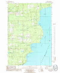 1985 Ogontz1985 Print · USGSThe Delta County coastline along Big Bay De Noc is captured here during the mid-eighties, showing a remote stretch of the Hiawatha National Forest. Researchers can locate the settlement of Ogontz, trace the path of Martin Creek, or find natural landmarks like Little Lake Sixteen.
End of results
Showing maps 1-2 of 2
Top cities near Ogontz
Frequently asked questions
- What are the different types of historical maps available for Ogontz?
- What is the oldest map of Ogontz?
- Where can I purchase historical maps of Ogontz for my home or office?
- Where can I download high-res historical maps of Ogontz?
- Are there historical topographic maps available for Ogontz?
- Is there historical aerial imagery available for Ogontz?
- Where are historical maps of Ogontz sourced from?