2020s Maps of Nahma Township, Michigan
Explore 12 historic maps of Nahma Township from the 2020s. These maps offer a rare glimpse into what life looked like during the 2020s — showing old roads, neighborhoods, homes, and landmarks that have changed or disappeared over time.
Whether you're researching your family's past, planning a metal detecting trip, or studying how Nahma Township's landscape evolved across the 2020s, these high-resolution maps are a powerful tool for exploring the history of this region.
- Focus on a specific era: All maps on this page are from the 2020s, giving you a focused view of this time period.
- See what’s changed: Compare century-old streets, trails, and buildings to today's modern landscape using overlays and satellite layers.
- Research with precision: Use these maps for genealogy, historical research, land use analysis, or educational projects.
- View, download, or print: Maps are fully viewable online in high resolution, and can be downloaded or printed for your own records.
Start exploring Nahma Township's history through authentic maps from the 2020s. This is your window into the past.
Nahma Township, MI maps
(12)- 2023 Map of Nahma, 2023 Print
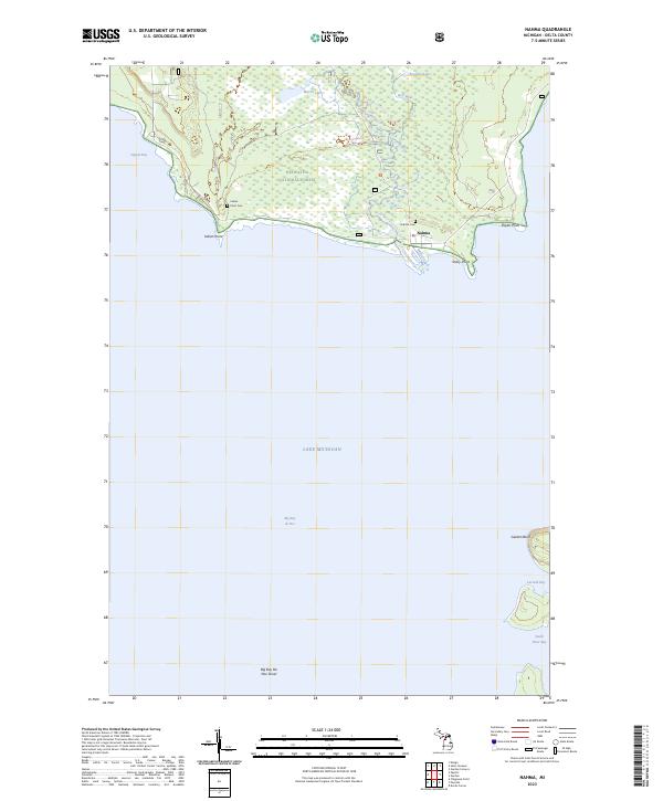 2023 Nahma2023 Print · USGSNahma and the Sturgeon River mouth are captured in this modern survey of the Big Bay de Noc shoreline. Researchers can trace the coastal geography of the Hiawatha National Forest and locate historical sites like Indian Point Cem and Nahma Cem.
 - 2023 Map of Garden, 2023 Print
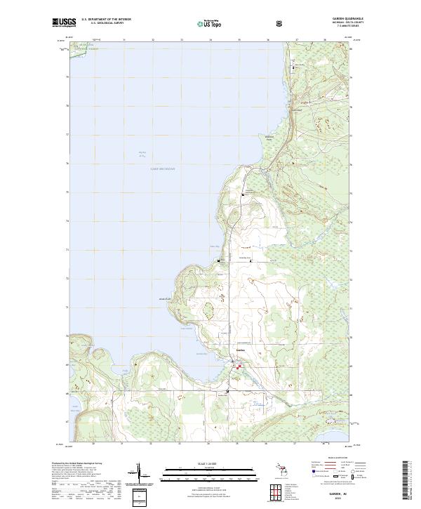 2023 Garden2023 Print · USGSThe Garden Peninsula comes to life in this modern survey of Delta County, showing the intersection of coastal life and the northern forest. Researchers can trace family history through numerous burial sites like Kates Bay Cem and New Garden Cem near Garden Bay.
 - 2023 Map of Ensign, 2023 Print
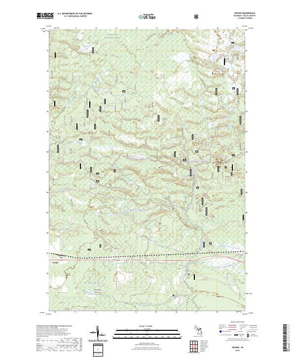 2023 Ensign2023 Print · USGSThe northern Stonington Peninsula comes into focus during this contemporary survey of Delta County's forested wetlands. Researchers can locate family landmarks such as the Johnston Cem, trace the headwaters of the Ogontz River, and explore the rural layout around Ensign.
 - 2023 Map of Garden Corners, 2023 Print
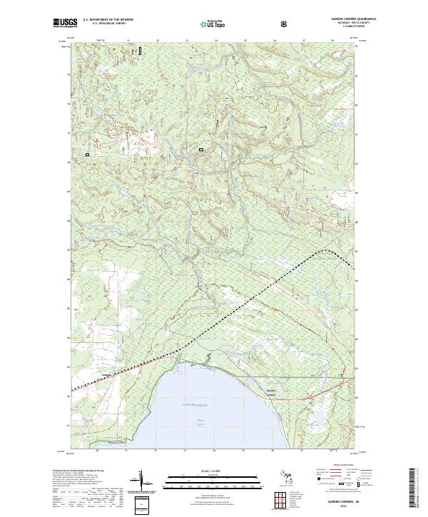 2023 Garden Corners2023 Print · USGSThe northern reaches of Big Bay de Noc in Delta County come into sharp focus in this recent survey. Researchers can trace the drainage of the Fishdam River and locate the small communities of Isabella and Garden Corners along the Lake Michigan shoreline.
 - 2023 Map of Saint Jacques, 2023 Print
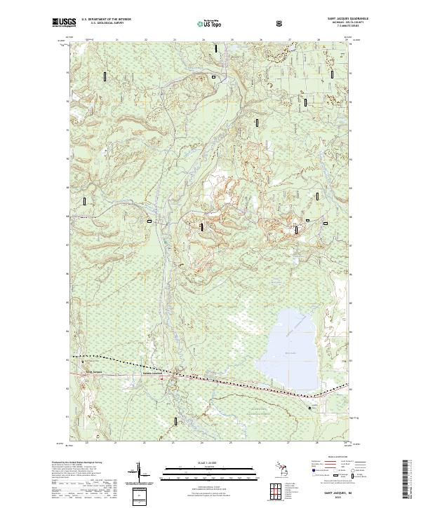 2023 Saint Jacques2023 Print · USGSThe Sturgeon River corridor and the settlement of Saint Jacques are shown in detail on this modern survey of the Hiawatha National Forest. Researchers can find Saint Jacques Cem, Isabella Cem, and the old Nahma Junction rail crossing.
 - 2023 Map of Waco Lake, 2023 Print
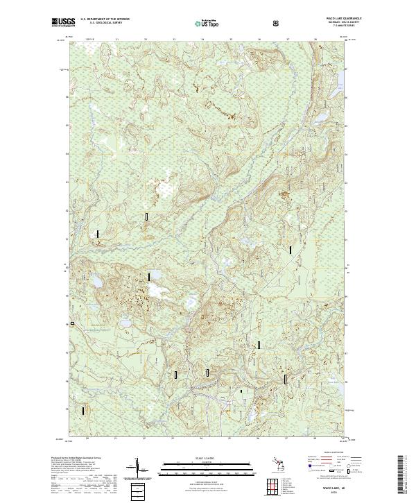 2023 Waco Lake2023 Print · USGSDelta County's forested interior is captured here in the early twenty-first century, showcasing a preserved wilderness of wetlands and glacial lakes. You can trace the path of the Nahma Grade Sno-mo Tr or locate remote water bodies like Waco Lake and Billy Good Lake.
 - 2023 Map of Poplar Lake, 2023 Print
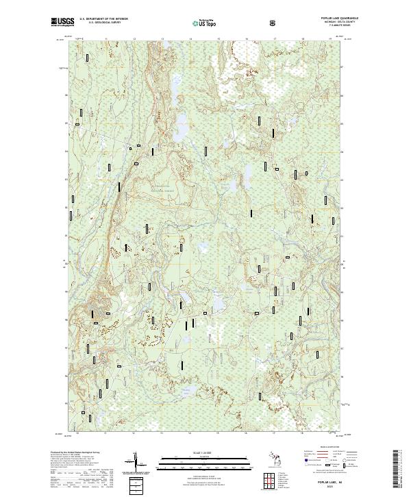 2023 Poplar Lake2023 Print · USGSDelta County in the Upper Peninsula remains a deep forest landscape within the Hiawatha National Forest. Outdoor historians and researchers can trace the protected corridors of the Whitefish Wild and Scenic River and find landmarks like Haymeadow Falls.
 - 2023 Map of Tie Lake, 2023 Print
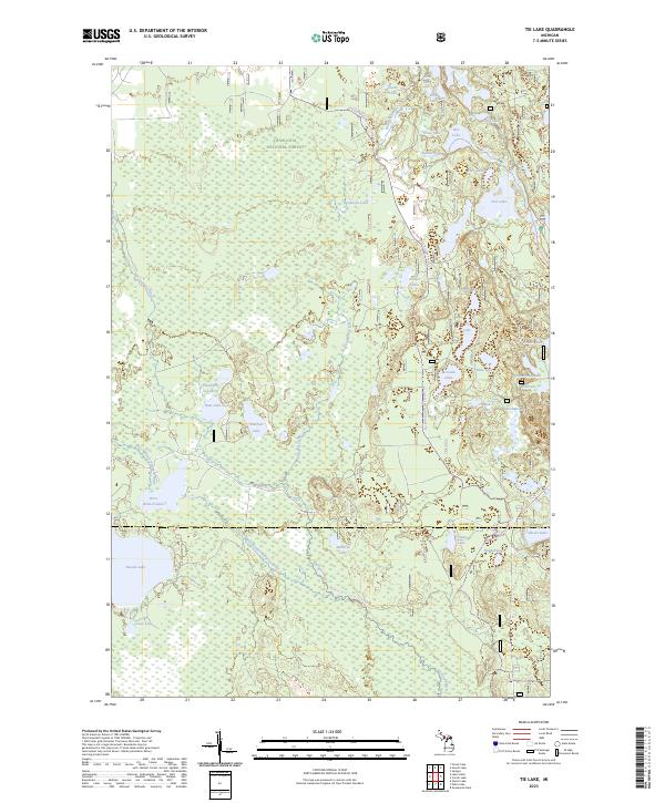 2023 Tie Lake2023 Print · USGSUpper Peninsula wilderness in the modern era reveals a landscape defined by protected forests and labyrinthine waterways. Researchers can trace the courses of the Indian Wild and Scenic River and find remote landmarks like Tie Lake and Nookomis Lake.
 - 2023 Map of Gooseneck Lake, 2023 Print
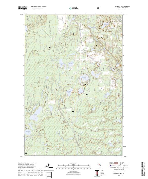 2023 Gooseneck Lake2023 Print · USGSThe northern woods of Delta County are captured here in a moment of modern forest management and recreation. Trace the paths of the Big Spring-Baldy Lake Snowmo Trl or explore the secluded shorelines of Gooseneck Lake and Van Winkle Lake.
 - 2023 Map of Lake Stella, 2023 Print
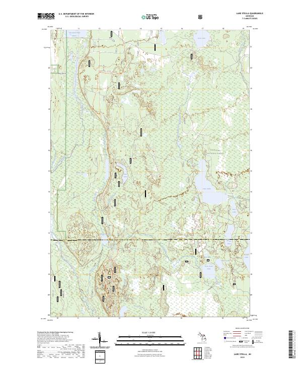 2023 Lake Stella2023 Print · USGSThe Hiawatha National Forest is shown in this recent survey as a vast network of glacial lakes and river systems in Michigan's Upper Peninsula. Researchers can trace the path of the Bay De Noc-Grand Island Trl and locate secluded water bodies like Lake Stella and Saul Lake.
 - 2023 Map of Ogontz, 2023 Print
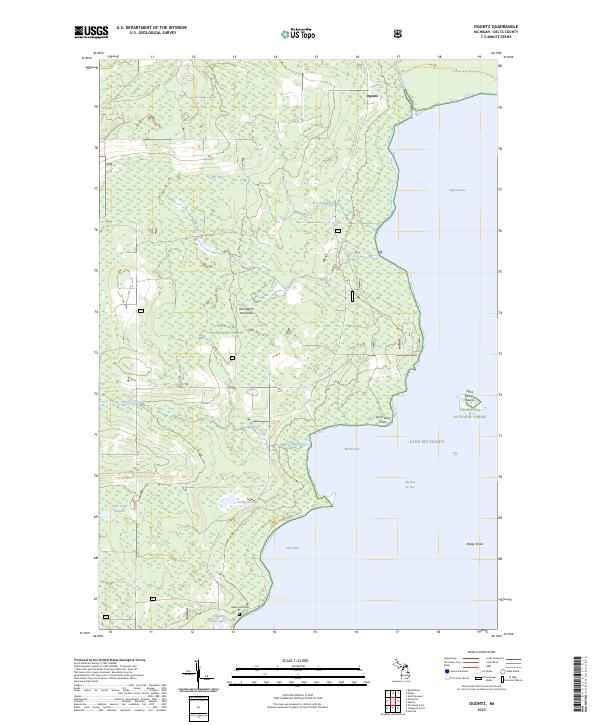 2023 Ogontz2023 Print · USGSThe Stonington Peninsula remains a landscape of forest and water in the early twenty-first century. Researchers can trace family roots at Indian Town Cem or explore the jagged coastline of Big Bay de Noc and Ogontz Bay.
 - 2023 Map of Corner Lake, 2023 Print
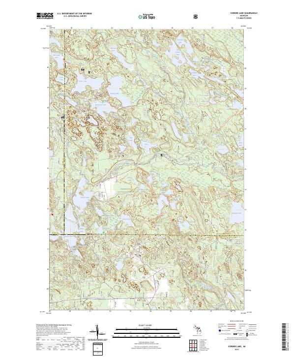 2023 Corner Lake2023 Print · USGSThe Upper Peninsula wilderness comes alive on this modern survey of the lake-studded intersection of Schoolcraft, Alger, and Delta counties. Outdoor historians can trace an extensive network of backwoods routes including Bruno's Run Trl, Pine Marten Run Trl, and the McKeever Hills Ski Trl.
End of results
Showing maps 1-12 of 12
Top cities near Nahma Township
Top neighborhoods of Nahma Township
Frequently asked questions
- What are the different types of historical maps available for Nahma Township?
- What is the oldest map of Nahma Township?
- Where can I purchase historical maps of Nahma Township for my home or office?
- Where can I download high-res historical maps of Nahma Township?
- Are there historical topographic maps available for Nahma Township?
- Is there historical aerial imagery available for Nahma Township?
- Where are historical maps of Nahma Township sourced from?