1930s Maps of Nahma Township, Michigan
Explore 9 historic maps of Nahma Township from the 1930s. These maps offer a rare glimpse into what life looked like during the 1930s — showing old roads, neighborhoods, homes, and landmarks that have changed or disappeared over time.
Whether you're researching your family's past, planning a metal detecting trip, or studying how Nahma Township's landscape evolved across the 1930s, these high-resolution maps are a powerful tool for exploring the history of this region.
- Focus on a specific era: All maps on this page are from the 1930s, giving you a focused view of this time period.
- See what’s changed: Compare century-old streets, trails, and buildings to today's modern landscape using overlays and satellite layers.
- Research with precision: Use these maps for genealogy, historical research, land use analysis, or educational projects.
- View, download, or print: Maps are fully viewable online in high resolution, and can be downloaded or printed for your own records.
Start exploring Nahma Township's history through authentic maps from the 1930s. This is your window into the past.
Nahma Township, MI maps
(9)- 1931 Map of Skeels Lake NE
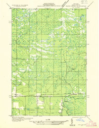
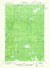
 1931 Skeels Lake NE1931 Print · USGSThe Upper Peninsula wilderness of the early thirties is captured here as a labyrinth of glacial waters. Researchers can trace the winding Indian River and locate remote landmarks like Hill Tower, Skeels Lake, and Straits Lake.
 - 1932 Map of Rapid River NE
 1932 Rapid River NE1932 Print · USGSDelta County's central timber and transit corridors are captured here in the early thirties as the Soo Line railroad connected rural townships. Researchers can pinpoint Ensign, find the Ogontz Cem, and trace the winding Ogontz River past the Seven Mile Dam.
 - 1932 Map of Garden NW and SW
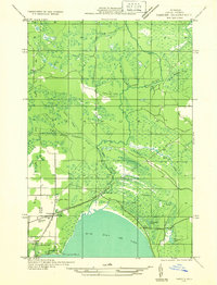
 1932 Garden NW and SW1932 Print · USGSThe Delta County coast and Sturgeon River valley come alive in the 1930s, documenting a landscape shaped by the timber industry. Researchers can trace the layout of Nahma, find family-named sites like Larson Sch, and locate remote logging outposts like Jobbers Camp.
 - 1932 Map of Skeels Lake SE
 1932 Skeels Lake SE1932 Print · USGSDelta County's backcountry is captured here during the early years of the National Forest system, showing a landscape defined by timber camps and glacial lakes. Local historians can trace the logging-era heritage through sites like Camp No 41 Lake and the winding course of the Northeast Branch Fishdam River.
 - 1932 Map of Garden SE
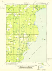
 1932 Garden SE1932 Print · USGSThe eastern shores of Big Bay de Noc appear in the early thirties, showing a coastal landscape of timber and small harbors. Genealogists can trace family footprints at Kates Bay Sch, Vans Harbor, and the Kates Bay Cem.
 - 1932 Map of Trenary SE
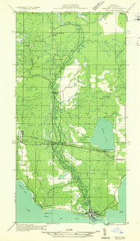
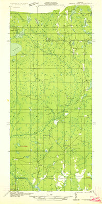
 1932 Trenary SE1932 Print · USGSDelta County was a hub of Northwoods logging during the early thirties, where timber camps and rail spurs threaded through the forest. Genealogists and historians can trace the locations of Mc Donald Camp, Schultz Camp, and the Nahma & Northern railroad.
 - 1932 Map of Rapid River SE
 1932 Rapid River SE1932 Print · USGSThe northern shores of Big Bay de Noc appear in the early 1930s as a quiet landscape of coastal marshes and timberlands. Local researchers can trace family roots at Grange Hall, visit the Silver Dale Sch, or locate old camps like Camp Ruh and Indian Town Lake.
 - 1932 Map of Skeels Lake NW and SW
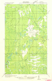
 1932 Skeels Lake NW and SW1932 Print · USGSUpper Peninsula timberlands and early recreational camps appear in this early 1930s survey of the Alger and Delta county line. Genealogists and historians can trace the Nahma and Northern railroad to isolated outposts like Allens Homestead and Buckhorn Lodge.
 - 1932 Map of Garden NE
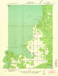
 1932 Garden NE1932 Print · USGSUpper Michigan's rugged shoreline and timbered interior are captured here in the early 1930s as the rail-and-road network expanded through Delta County. Researchers can trace local genealogy and land use at Isabella, the Congl Ch, and Van Winkle Sta.
End of results
Showing maps 1-9 of 9
Top cities near Nahma Township
Top neighborhoods of Nahma Township
Frequently asked questions
- What are the different types of historical maps available for Nahma Township?
- What is the oldest map of Nahma Township?
- Where can I purchase historical maps of Nahma Township for my home or office?
- Where can I download high-res historical maps of Nahma Township?
- Are there historical topographic maps available for Nahma Township?
- Is there historical aerial imagery available for Nahma Township?
- Where are historical maps of Nahma Township sourced from?