Old Maps of Nahma Township, Michigan for Academic Research
Study the evolution of Nahma Township with 94 high-resolution historic maps. Whether you're teaching, researching, or modeling changes in land use, these maps provide essential visual documentation of urban, environmental, and geographic change.
- Analyze long-term change: Track patterns in development, transportation, and natural features.
- Ideal for environmental or urban studies: Support academic projects with primary historical map data.
- Use in the classroom or lab: Educators and researchers rely on these maps to bring historical context to life.
These maps are a powerful tool for teaching, research, and visualizing how Nahma Township has changed over the decades.
Nahma Township, MI maps
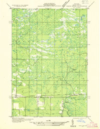
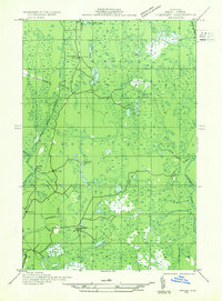
(94)- 1931 Map of Skeels Lake NE
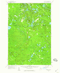
 1931 Skeels Lake NE1931 Print · USGSThe Upper Peninsula wilderness of the early thirties is captured here as a labyrinth of glacial waters. Researchers can trace the winding Indian River and locate remote landmarks like Hill Tower, Skeels Lake, and Straits Lake.
 - 1932 Map of Rapid River NE
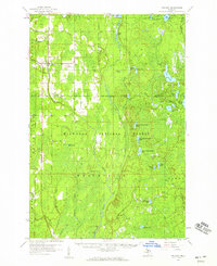
 1932 Rapid River NE1932 Print · USGSDelta County's central timber and transit corridors are captured here in the early thirties as the Soo Line railroad connected rural townships. Researchers can pinpoint Ensign, find the Ogontz Cem, and trace the winding Ogontz River past the Seven Mile Dam.
 - 1932 Map of Garden NW and SW
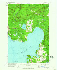
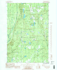
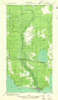 1932 Garden NW and SW1932 Print · USGSThe Delta County coast and Sturgeon River valley come alive in the 1930s, documenting a landscape shaped by the timber industry. Researchers can trace the layout of Nahma, find family-named sites like Larson Sch, and locate remote logging outposts like Jobbers Camp.
 - 1932 Map of Skeels Lake SE
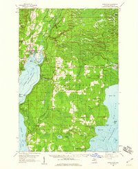
 1932 Skeels Lake SE1932 Print · USGSDelta County's backcountry is captured here during the early years of the National Forest system, showing a landscape defined by timber camps and glacial lakes. Local historians can trace the logging-era heritage through sites like Camp No 41 Lake and the winding course of the Northeast Branch Fishdam River.
 - 1932 Map of Garden SE
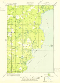
 1932 Garden SE1932 Print · USGSThe eastern shores of Big Bay de Noc appear in the early thirties, showing a coastal landscape of timber and small harbors. Genealogists can trace family footprints at Kates Bay Sch, Vans Harbor, and the Kates Bay Cem.
 - 1932 Map of Trenary SE
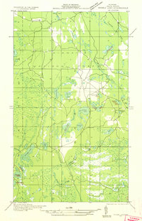
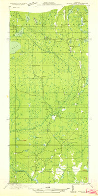
 1932 Trenary SE1932 Print · USGSDelta County was a hub of Northwoods logging during the early thirties, where timber camps and rail spurs threaded through the forest. Genealogists and historians can trace the locations of Mc Donald Camp, Schultz Camp, and the Nahma & Northern railroad.
 - 1932 Map of Rapid River SE
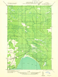
 1932 Rapid River SE1932 Print · USGSThe northern shores of Big Bay de Noc appear in the early 1930s as a quiet landscape of coastal marshes and timberlands. Local researchers can trace family roots at Grange Hall, visit the Silver Dale Sch, or locate old camps like Camp Ruh and Indian Town Lake.
 - 1932 Map of Skeels Lake NW and SW
 1932 Skeels Lake NW and SW1932 Print · USGSUpper Peninsula timberlands and early recreational camps appear in this early 1930s survey of the Alger and Delta county line. Genealogists and historians can trace the Nahma and Northern railroad to isolated outposts like Allens Homestead and Buckhorn Lodge.
 - 1932 Map of Garden NE
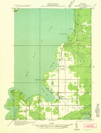
 1932 Garden NE1932 Print · USGSUpper Michigan's rugged shoreline and timbered interior are captured here in the early 1930s as the rail-and-road network expanded through Delta County. Researchers can trace local genealogy and land use at Isabella, the Congl Ch, and Van Winkle Sta.
 - 1954 Map of Escanaba, 1967 Print
 1954 Escanaba1967 Print · USGSThe Upper Peninsula and Door County shorelines meet here in the mid-fifties, showing the vital maritime and timber networks of the Great Lakes. Researchers can trace historic rail lines, old fire lookouts like the Stonington Fire Tower, and island settlements such as Washington Island.2 unique versions available
 - 1957 Map of Escanaba
 1957 Escanaba1957 Print · USGSThe Upper Peninsula and Door County shorelines meet in the mid-fifties, capturing a landscape of timber, iron, and maritime trade. Genealogists and local historians can trace the Chicago & North Western RR through settlements like Hermansville or locate St Vitals Church and the Potawatome Indian Reservation.
 - 1958 Map of Escanaba
 1958 Escanaba1958 Print · USGSNorthern Lake Michigan maritime commerce and timberlands are captured here in the mid-fifties. Genealogists and historians can trace rail networks like the Escanaba and Lake Superior or locate island settlements such as Detroit Harbor and Fish Creek.
 - 1958 Map of Corner Lake, 1959 Print
 1958 Corner Lake1959 Print · USGSIn Michigan's Upper Peninsula during the late fifties, this wilderness terrain was a hub for forestry and seasonal camps within the Hiawatha National Forest. Researchers can locate the settlement of Steuben, trace the Railroad Grade, or identify isolated sites like Camp Twenty-six and the Petoskey Hunting Club.2 unique versions available
 - 1958 Map of Trenary, 1959 Print
 1958 Trenary1959 Print · USGSThe Upper Peninsula landscape around the village of Trenary is shown here during the late fifties, featuring the path of the Minneapolis St Paul and Sault Ste Marie rail line. Researchers can trace remote sites like Osier and Cyr or the network of lakes including Upper Eighteenmile Lake.3 unique versions available
 - 1958 Map of Garden, 1959 Print
 1958 Garden1959 Print · USGSThe Garden Peninsula in the late fifties shows a landscape of timber towns and fishing harbors along the Big Bay de Noc. Researchers can trace historic family sites and early infrastructure from Vans Harbor to the St Lawrence Ch and Isabella rail stop.3 unique versions available
 - 1958 Map of Rapid River, 1960 Print
 1958 Rapid River1960 Print · USGSUpper Peninsula timberlands and shores meet in the late fifties along the dual bays of Lake Michigan. Researchers can trace family roots at Garth Cem and Lakewood Cem or locate old community hubs like Ensign and the Stonington Community Hall.2 unique versions available
 - 1958 Map of Marquette, 1968 Print
 1958 Marquette1968 Print · USGSThe Upper Peninsula’s central corridor is captured here in the mid-twentieth century as mining and timber industries thrived alongside new military installations. Genealogists and historians can trace the rail lines of the Soo Line Railroad through settlements like Gwinn, Turin, and Chatham.2 unique versions available
 - 1960 Map of Marquette
 1960 Marquette1960 Print · USGSUpper Peninsula mining and maritime commerce reach their peak in the late fifties across the Lake Superior shoreline. Genealogists and historians can locate remote settlements like Big Bay and Dukes, while tracing the Cyr Mine and the active rail lines of the Lake Superior and Ishpeming railroad.
 - 1961 Map of Marquette
 1961 Marquette1961 Print · USGSUpper Peninsula life in the early sixties centered on the iron docks and timber stands of the Lake Superior shore. Genealogists and historians can trace rail-to-port connections via the Lake Superior and Ishpeming Railroad and locate active sites like Republic Mine or the K.I. Sawyer Air Force Base.
 - 1968 Map of Marquette, 1977 Print
 1968 Marquette1977 Print · USGSThe Upper Peninsula iron range and Lake Superior coastline are captured here in the late sixties. Genealogists and historians can trace the rail-to-port infrastructure and the Cold War presence of K I Sawyer Air Force Base alongside towns like Ishpeming and Munising.
 - 1983 Map of Manistique
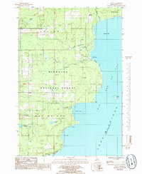
 1983 Manistique1983 Print · USGSThe northern shores of Lake Michigan and the Garden Peninsula appear here in the early eighties. Historians can trace the Soo Line rail corridor and explore coastal settlements like Nahma, Fayette, and the harbor town of Manistique.
 - 1983 Map of Munising
 1983 Munising1983 Print · USGSThe Upper Peninsula lakefront and deep timberlands are documented here in the early eighties, centered on the Munising harbor. Genealogists and historians can trace rail stops along the Soo Line and remote outposts like Shingleton, Eben Junction, and Traunik.2 unique versions available
 - 1985 Map of Poplar Lake
 1985 Poplar Lake1985 Print · USGSMasonville and the Hiawatha National Forest are captured here in the mid-1980s, showcasing a landscape defined by glacial lakes and old timber corridors. Trace local history along the Old RR Grade, the Bay De Noc/Grand Island Trail, and the secluded waters of Upper Eighteenmile Lake.2 unique versions available
 - 1985 Map of Ensign
 1985 Ensign1985 Print · USGSDelta County's timberlands and marshes are documented here in the mid-1980s, revealing a landscape of remote work sites and small settlements. Genealogists and researchers can locate Ogontz Cem, the Nahma Grade, and the small community of Ensign.
 - 1985 Map of Ogontz
 1985 Ogontz1985 Print · USGSThe Delta County coastline along Big Bay De Noc is captured here during the mid-eighties, showing a remote stretch of the Hiawatha National Forest. Researchers can locate the settlement of Ogontz, trace the path of Martin Creek, or find natural landmarks like Little Lake Sixteen.
Showing maps 1-25 of 94
Top cities near Nahma Township
Top neighborhoods of Nahma Township
Frequently asked questions
- What are the different types of historical maps available for Nahma Township?
- What is the oldest map of Nahma Township?
- Where can I purchase historical maps of Nahma Township for my home or office?
- Where can I download high-res historical maps of Nahma Township?
- Are there historical topographic maps available for Nahma Township?
- Is there historical aerial imagery available for Nahma Township?
- Where are historical maps of Nahma Township sourced from?