1980s Maps of Larch, Wells Township
Explore 2 historic maps of Larch from the 1980s. These maps offer a rare glimpse into what life looked like during the 1980s — showing old roads, neighborhoods, homes, and landmarks that have changed or disappeared over time.
Whether you're researching your family's past, planning a metal detecting trip, or studying how Larch's landscape evolved across the 1980s, these high-resolution maps are a powerful tool for exploring the history of this region.
- Focus on a specific era: All maps on this page are from the 1980s, giving you a focused view of this time period.
- See what’s changed: Compare century-old streets, trails, and buildings to today's modern landscape using overlays and satellite layers.
- Research with precision: Use these maps for genealogy, historical research, land use analysis, or educational projects.
- View, download, or print: Maps are fully viewable online in high resolution, and can be downloaded or printed for your own records.
Start exploring Larch's history through authentic maps from the 1980s. This is your window into the past.
Larch, Wells Township maps
(2)- 1982 Map of Escanaba
 1982 Escanaba1982 Print · USGSUpper Peninsula timber and mining country come to life in this early 1980s survey of the lakefront and forest interior. Trace family roots and industrial history through settlements like Norway and Gladstone, or locate the Appleton Mine and Fernwood Cem near the rail lines.
 - 1985 Map of Gladstone
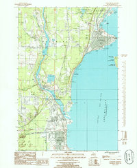 1985 Gladstone1985 Print · USGSThe Delta County coastline in the mid-eighties shows a busy industrial and maritime corridor between Gladstone and Escanaba. Local researchers can trace landmarks like the Squaw Point Lighthouse, Fernwood Cemetery, and the West Gladstone Airport.
End of results
Showing maps 1-2 of 2
Top cities near Larch
- Escanaba historical maps
- Gladstone historical maps
- Wells historical maps
- Ford River historical maps
- Brampton historical maps
- Ensign historical maps
See more
Frequently asked questions
- What are the different types of historical maps available for Larch?
- What is the oldest map of Larch?
- Where can I purchase historical maps of Larch for my home or office?
- Where can I download high-res historical maps of Larch?
- Are there historical topographic maps available for Larch?
- Is there historical aerial imagery available for Larch?
- Where are historical maps of Larch sourced from?