1920s Maps of Flint Charter Township, Michigan
Explore 6 historic maps of Flint Charter Township from the 1920s. These maps offer a rare glimpse into what life looked like during the 1920s — showing old roads, neighborhoods, homes, and landmarks that have changed or disappeared over time.
Whether you're researching your family's past, planning a metal detecting trip, or studying how Flint Charter Township's landscape evolved across the 1920s, these high-resolution maps are a powerful tool for exploring the history of this region.
- Focus on a specific era: All maps on this page are from the 1920s, giving you a focused view of this time period.
- See what’s changed: Compare century-old streets, trails, and buildings to today's modern landscape using overlays and satellite layers.
- Research with precision: Use these maps for genealogy, historical research, land use analysis, or educational projects.
- View, download, or print: Maps are fully viewable online in high resolution, and can be downloaded or printed for your own records.
Start exploring Flint Charter Township's history through authentic maps from the 1920s. This is your window into the past.
Flint Charter Township, MI maps
(6)- 1920 Map of Flint
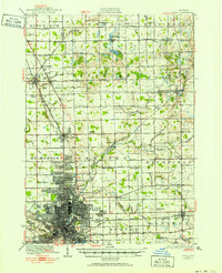 1920 Flint1920 Print · USGSFlint and the surrounding Genesee County townships appear in this post-war survey during a period of intense industrial and civic growth. Genealogists and historians can trace numerous rural school sites like Beecher School and major rail lines including the Pere Marquette.2 unique versions available
 - 1920 Map of Holly, 1964 Print
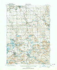 1920 Holly1964 Print · USGSOakland and Genesee counties at the height of the rail era show a landscape of interconnected small towns and lakeside settlements. Trace the legacy of early transit via the United Electric Railway or locate family landmarks like Groveland Mills and Hadley Cemetery.
 - 1921 Map of Burt
 1921 Burt1921 Print · USGSSaginaw and Genesee Counties are captured here at the end of the Great War, showing a landscape of tight-knit farming communities and early electric transit. Researchers can trace family roots through dozens of named sites like St Michaels Church, Marr School, and the Michigan Electric Railway.2 unique versions available
 - 1922 Map of Holly
 1922 Holly1922 Print · USGSSoutheast of the industrial rise of Flint in the early 1920s, this region reveals a landscape of lakeside settlements and small-town village life. Genealogists can locate family-named sites like Ainsworth Corners, Gravel Lake Cemetery, and dozens of rural schoolhouses including Atherton School and Howe School.3 unique versions available
 - 1922 Map of Durand
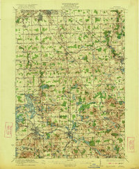
 1922 Durand1922 Print · USGSShiawassee and Genesee counties come alive in the early 1920s as a bustling junction of rail and river. Researchers can trace the sprawling Grand Trunk lines through Durand or locate family roots near the Crapo Farm and Unity Grange.4 unique versions available
 - 1922 Map of Flint
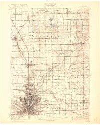 1922 Flint1922 Print · USGSGenesee County comes to life in the early twenties, showing the industrial rise of the vehicle city alongside its rural townships. Researchers can trace family sites near Gracelawn Cemetery or locate old schoolhouses like Boutwell School and Holden School.3 unique versions available
End of results
Showing maps 1-6 of 6
Top cities near Flint Charter Township
- Flint historical maps
- Burton historical maps
- Springfield Charter Township historical maps
- Fenton historical maps
- Tyrone Township historical maps
- Flushing historical maps
See more
Frequently asked questions
- What are the different types of historical maps available for Flint Charter Township?
- What is the oldest map of Flint Charter Township?
- Where can I purchase historical maps of Flint Charter Township for my home or office?
- Where can I download high-res historical maps of Flint Charter Township?
- Are there historical topographic maps available for Flint Charter Township?
- Is there historical aerial imagery available for Flint Charter Township?
- Where are historical maps of Flint Charter Township sourced from?