1910s Maps of Gratiot County, Michigan
Explore 2 historic maps of Gratiot County from the 1910s. These maps offer a rare glimpse into what life looked like during the 1910s — showing old roads, neighborhoods, homes, and landmarks that have changed or disappeared over time.
Whether you're researching your family's past, planning a metal detecting trip, or studying how Gratiot County's landscape evolved across the 1910s, these high-resolution maps are a powerful tool for exploring the history of this region.
- Focus on a specific era: All maps on this page are from the 1910s, giving you a focused view of this time period.
- See what’s changed: Compare century-old streets, trails, and buildings to today's modern landscape using overlays and satellite layers.
- Research with precision: Use these maps for genealogy, historical research, land use analysis, or educational projects.
- View, download, or print: Maps are fully viewable online in high resolution, and can be downloaded or printed for your own records.
Start exploring Gratiot County's history through authentic maps from the 1910s. This is your window into the past.
Gratiot County, MI maps
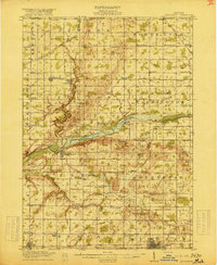
(2)- 1918 Map of Elsie
 1918 Elsie1918 Print · USGSCentral Michigan farmland and river valleys are captured here at the end of the Great War. Genealogists can trace family roots through numerous schoolhouses like Elba Center School and early rail stops at Carland, Bannister, and Munson Crossing.3 unique versions available
 - 1918 Map of Perrinton
 1918 Perrinton1918 Print · USGSCentral Michigan's fertile farm country is captured here during the First World War era, showing a landscape tightly organized around rail lines and township schools. Researchers can trace the family-named school districts and small village centers like Perrinton, Eureka, and the commercial hub at Newark Store.2 unique versions available
End of results
Showing maps 1-2 of 2
Top cities of Gratiot County
Frequently asked questions
- What are the different types of historical maps available for Gratiot County?
- What is the oldest map of Gratiot County?
- Where can I purchase historical maps of Gratiot County for my home or office?
- Where can I download high-res historical maps of Gratiot County?
- Are there historical topographic maps available for Gratiot County?
- Is there historical aerial imagery available for Gratiot County?
- Where are historical maps of Gratiot County sourced from?