1960s Maps of Gratiot County, Michigan
Explore 9 historic maps of Gratiot County from the 1960s. These maps offer a rare glimpse into what life looked like during the 1960s — showing old roads, neighborhoods, homes, and landmarks that have changed or disappeared over time.
Whether you're researching your family's past, planning a metal detecting trip, or studying how Gratiot County's landscape evolved across the 1960s, these high-resolution maps are a powerful tool for exploring the history of this region.
- Focus on a specific era: All maps on this page are from the 1960s, giving you a focused view of this time period.
- See what’s changed: Compare century-old streets, trails, and buildings to today's modern landscape using overlays and satellite layers.
- Research with precision: Use these maps for genealogy, historical research, land use analysis, or educational projects.
- View, download, or print: Maps are fully viewable online in high resolution, and can be downloaded or printed for your own records.
Start exploring Gratiot County's history through authentic maps from the 1960s. This is your window into the past.
Gratiot County, MI maps
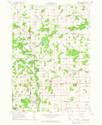
(9)- 1965 Map of Sumner, 1966 Print
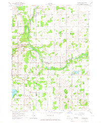 1965 Sumner1966 Print · USGSGratiot and Montcalm counties are captured here in the mid-1960s, showing a rural landscape where the Pine River winds through agricultural townships. Researchers can trace family history through local sites like Spencer Chapel, Elm Hall Cem, and Crystal Sch.2 unique versions available
 - 1965 Map of Perrinton, 1966 Print
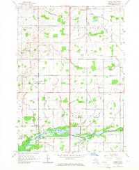
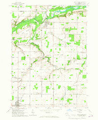
 1965 Perrinton1966 Print · USGSGratiot County's agricultural heartland is captured here in the mid-sixties as the Pine River flows toward the Rainbow Lake reservoir. Researchers can trace family roots through numerous rural landmarks like Old Fulton Cem, Fulton High Sch, and the Middleton settlement.2 unique versions available
 - 1965 Map of Pompeii, 1966 Print
 1965 Pompeii1966 Print · USGSGratiot County in the mid-sixties shows a landscape of productive Michigan farmland organized around small rural crossings and the winding river bottoms. Genealogists can trace family roots at North Star Cemetery or locate the Washington Center Sch and Ola settlement.
 - 1965 Map of St. Johns North, 1967 Print
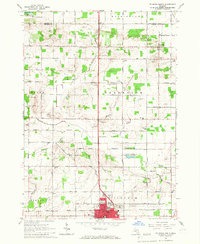 1965 St. Johns North1967 Print · USGSClinton County agriculture and the growing city of St Johns are captured here in the mid-1960s. Researchers can trace rural life through landmarks like Union Home Cem, the Sage Sch, and the Maple River State Game Area.2 unique versions available
 - 1965 Map of Riverdale, 1967 Print
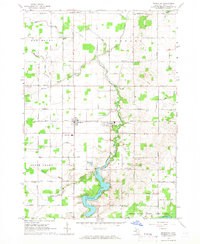
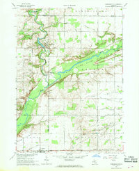
 1965 Riverdale1967 Print · USGSThe Pine River valley and the Chesapeake and Ohio railroad define this mid-1960s landscape where Gratiot, Montcalm, and Isabella counties meet. Genealogists and local historians can trace rural roots at Rust and Hay Sch, Jerseyville Ch, and Sibley Cem.
 - 1965 Map of Maple Rapids, 1967 Print
 1965 Maple Rapids1967 Print · USGSClinton County's river valley comes into sharp focus during the mid-sixties, showing the agricultural heartland between Maple Rapids and Fowler. Researchers can trace the locations of the Frink Sch, Lowe Ch, and numerous family cemeteries like Beech Cem.2 unique versions available
 - 1966 Map of Midland
 1966 Midland1966 Print · USGSCentral Michigan in the mid-1960s shows a landscape of growing manufacturing hubs and active resource extraction. Genealogists and historians can trace the rail corridors of the Grand Trunk Western or locate family-named landmarks near Oil wells and the Muskegon River.
 - 1967 Map of Hubbardston, 1968 Print
 1967 Hubbardston1968 Print · USGSThe borderlands of Ionia and Clinton counties in the late sixties reveal a landscape of river-fed agriculture and expanding state lands. Genealogists and local historians can trace the foundations of Hubbardston and Pewamo or locate rural sites like West Side Cem and the Grand Trunk rail corridor.
 - 1967 Map of Carson City, 1968 Print
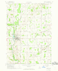 1967 Carson City1968 Print · USGSMid-Michigan farm country and the industrial center of Carson City are captured here in the late sixties. Genealogists and local historians can trace the foundations of the community through landmarks like the Oil Refinery, North Shade Sch, and Mt Hope Ch.
End of results
Showing maps 1-9 of 9
Top cities of Gratiot County
Frequently asked questions
- What are the different types of historical maps available for Gratiot County?
- What is the oldest map of Gratiot County?
- Where can I purchase historical maps of Gratiot County for my home or office?
- Where can I download high-res historical maps of Gratiot County?
- Are there historical topographic maps available for Gratiot County?
- Is there historical aerial imagery available for Gratiot County?
- Where are historical maps of Gratiot County sourced from?