1980s Maps of Houghton County, Michigan
Explore 20 historic maps of Houghton County from the 1980s. These maps offer a rare glimpse into what life looked like during the 1980s — showing old roads, neighborhoods, homes, and landmarks that have changed or disappeared over time.
Whether you're researching your family's past, planning a metal detecting trip, or studying how Houghton County's landscape evolved across the 1980s, these high-resolution maps are a powerful tool for exploring the history of this region.
- Focus on a specific era: All maps on this page are from the 1980s, giving you a focused view of this time period.
- See what’s changed: Compare century-old streets, trails, and buildings to today's modern landscape using overlays and satellite layers.
- Research with precision: Use these maps for genealogy, historical research, land use analysis, or educational projects.
- View, download, or print: Maps are fully viewable online in high resolution, and can be downloaded or printed for your own records.
Start exploring Houghton County's history through authentic maps from the 1980s. This is your window into the past.
Houghton County, MI maps
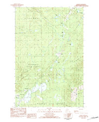
(20)- 1982 Map of Nisula, 1983 Print
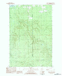
 1982 Nisula1983 Print · USGSThe townships of Laird and Bohemia appear in the early eighties as a landscape of dense forests and river headwaters. Researchers can locate the community of Nisula, find St Henrys Ch, and trace the path of the Otter River or the old railroad Siding.
 - 1982 Map of Sparrow Rapids, 1983 Print
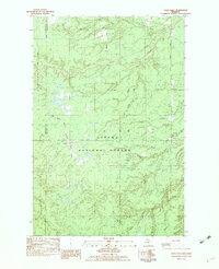
 1982 Sparrow Rapids1983 Print · USGSIn the early eighties, this stretch of the Upper Peninsula was a landscape of dense timber and winding waterways along the East Branch Ontonagon River. Genealogists and historians can trace the paths of an Old RR Grade and find early recreational landmarks like the Sparrow Rapids Campground and Onion Falls.
 - 1982 Map of Donken, 1983 Print
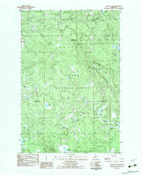
 1982 Donken1983 Print · USGSThe Keweenaw Peninsula forestlands and glacial lakes are shown here in the early eighties as a quiet region of timber and recreation. Local historians can trace the small settlements of Donken and Toivola or the boundaries of Twin Lakes State Park.
 - 1982 Map of Echo Lake, 1983 Print
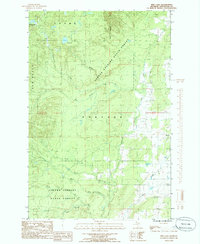
 1982 Echo Lake1983 Print · USGSHoughton County’s backcountry in the early eighties was a landscape of timber and rail within the Ottawa National Forest. Genealogists and outdoorsmen can trace the Escanaba and Lake Superior rail line as it passes through Frost and Connors near Echo Lake.
 - 1982 Map of Kenton, 1983 Print
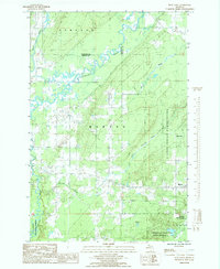
 1982 Kenton1983 Print · USGSUpper Peninsula timber and river lands come into focus during the early eighties, centered on the settlement of Kenton. Researchers can trace the Old RR Grade through the Ottawa National Forest and locate family landmarks like the local Cem or the camps near Tepee Lake.
 - 1982 Map of Rousseau, 1983 Print
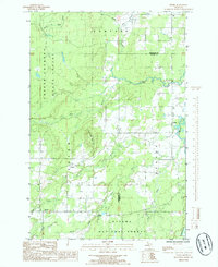
 1982 Rousseau1983 Print · USGSUpper Peninsula timber country is captured here in the early eighties, showing the remote settlements and logging remnants of Ontonagon County. Genealogists and hikers can trace the Old RR Grade and locate long-standing landmarks like Rousseau, Pori, and the Cem.
 - 1982 Map of Winona South, 1983 Print
 1982 Winona South1983 Print · USGSUpper Peninsula copper country and timberlands are documented here in the early 1980s as industry and nature overlap. Local historians can trace the old Railroad grade, locate the Woodland Cemetery, and identify mining remnants like Tailings near Winona.
 - 1982 Map of Winona North, 1983 Print
 1982 Winona North1983 Print · USGSThe Upper Peninsula shoreline and the timberlands of Stanton are captured here in the early 1980s. Local researchers can trace the roads near Winona, locate the Townhall at Misery Bay, and find remote outposts like Camp 18 and Ahola.
 - 1982 Map of Vista Falls, 1983 Print
 1982 Vista Falls1983 Print · USGSHoughton and Ontonagon counties are captured in the early 1980s as a landscape of timber and rushing water within the Ottawa National Forest. Researchers can trace the legacy of Michigan logging along the Old RR Grade and locate features like Vista Falls and Maronen Hill.
 - 1982 Map of Glitter Lake, 1983 Print
 1982 Glitter Lake1983 Print · USGSUpper Michigan's lake country is captured here in the early eighties, spanning the wooded border between Houghton and Iron counties. Researchers can trace the water systems of the Ottawa National Forest, from Passmore Springs to remote shores like Glitter Lake and Lake Thirteen.
 - 1984 Map of Pine Lake, 1985 Print
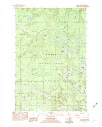
 1984 Pine Lake1985 Print · USGSHoughton County’s dense timberlands and river systems are documented here in the mid-1980s. Local researchers can locate the settlement of Tapiola, a local Cem, and the winding paths of the Elm River and Otter River.
 - 1984 Map of Portage Entry, 1986 Print
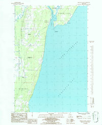 1984 Portage Entry1986 Print · USGSKeweenaw Bay and the strategic canal entrance at Jacobsville are captured in this mid-eighties survey. Genealogists and local historians can trace the foundations of Jacobsville and Klingville, locate the Portage Entry Lighthouse, and find the historic Crebassa Latitude Post.
 - 1985 Map of Otter Lake
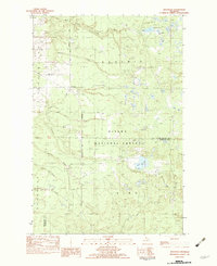
 1985 Otter Lake1985 Print · USGSThe Copper Country wilderness comes into focus in the mid-1980s, showing a landscape defined by the winding Sturgeon River and the forested border of Baraga County. Researchers can trace the rural communities of Tapiola and Askel or follow the old industrial grades through the Copper State Forest.
 - 1985 Map of Bear Town
 1985 Bear Town1985 Print · USGSUpper Peninsula forests and winding river valleys dominate this mid-eighties record of Baraga County. Researchers can trace the path of the Old RR Grade and the Trading Strip through the L'Anse Indian Reservation and the town of Baraga.
 - 1985 Map of Pelkie
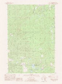
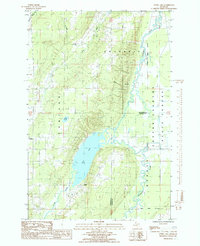
 1985 Pelkie1985 Print · USGSUpper Peninsula life in the mid-1980s is captured here as small communities like Pelkie and Alston thrive near the confluence of the Sturgeon River. Researchers can trace old routes like the West Grade or locate landmarks like Limestone Mountain.
 - 1985 Map of Hancock
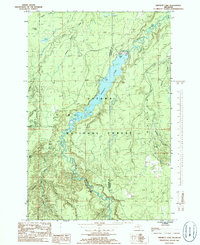
 1985 Hancock1985 Print · USGSThe Keweenaw Peninsula in the mid-1980s reveals a landscape shaped by copper and the Great Lakes. You can trace the industrial legacy of the region through the Quincy Mine, the Old RR Grade, and old cemeteries like Forest Hill Cem.3 unique versions available
 - 1985 Map of Sidnaw, 1986 Print
 1985 Sidnaw1986 Print · USGSThe community of Sidnaw and the surrounding timberlands of the Ottawa National Forest are captured here in the mid-1980s. Local history researchers can trace the old Sid RR Grade, explore the edges of the L'Anse Indian Reservation, and locate family camps near St George Lake.
 - 1985 Map of Marten Lake, 1986 Print
 1985 Marten Lake1986 Print · USGSThe Upper Peninsula wilderness near the Houghton and Iron County line is captured here in the mid-1980s. Trace the remote waters of Lake Sainte Kathryn, locate the Roadside Spring by Kunze Lake, and explore the glacial landscape of the Ottawa National Forest.
 - 1985 Map of Prickett Lake, 1986 Print
 1985 Prickett Lake1986 Print · USGSThe Sturgeon River valley in the mid-1980s reveals a wilderness landscape shaped by water and timber on the Houghton and Baraga county line. Genealogists and outdoorsmen can trace the rugged topography of Silver Mountain and the remote course of Prickett Lake or Sturgeon Falls.
 - 1989 Map of Iron River, 1990 Print
 1989 Iron River1990 Print · USGSUpper Peninsula mining and timber lands are documented here in the late 1980s, showcasing the region's industrial and natural interface. Researchers can trace the iron heritage through the Monongahela Mine and local junctions like Kelso Junction and Amasa.
End of results
Showing maps 1-20 of 20
Top cities of Houghton County
Frequently asked questions
- What are the different types of historical maps available for Houghton County?
- What is the oldest map of Houghton County?
- Where can I purchase historical maps of Houghton County for my home or office?
- Where can I download high-res historical maps of Houghton County?
- Are there historical topographic maps available for Houghton County?
- Is there historical aerial imagery available for Houghton County?
- Where are historical maps of Houghton County sourced from?