1990s Maps of Houghton County, Michigan
Explore 11 historic maps of Houghton County from the 1990s. These maps offer a rare glimpse into what life looked like during the 1990s — showing old roads, neighborhoods, homes, and landmarks that have changed or disappeared over time.
Whether you're researching your family's past, planning a metal detecting trip, or studying how Houghton County's landscape evolved across the 1990s, these high-resolution maps are a powerful tool for exploring the history of this region.
- Focus on a specific era: All maps on this page are from the 1990s, giving you a focused view of this time period.
- See what’s changed: Compare century-old streets, trails, and buildings to today's modern landscape using overlays and satellite layers.
- Research with precision: Use these maps for genealogy, historical research, land use analysis, or educational projects.
- View, download, or print: Maps are fully viewable online in high resolution, and can be downloaded or printed for your own records.
Start exploring Houghton County's history through authentic maps from the 1990s. This is your window into the past.
Houghton County, MI maps
(11)- 1991 Map of L'Anse
 1991 L'Anse1991 Print · USGSUpper Peninsula life in the early nineties centered on the waters of Keweenaw Bay and the timber-rich highlands of the Huron Mountains. Genealogists and researchers can trace the rail-and-road connections between L'Anse, Baraga, and smaller communities like Pequaming and Assinins.2 unique versions available
 - 1999 Map of Pelkie, 2004 Print
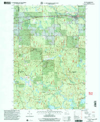
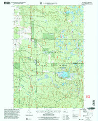
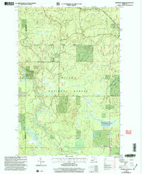
 1999 Pelkie2004 Print · USGSUpper Peninsula timber country and river valleys are captured here at the close of the century, near the Baraga and Houghton county line. Researchers can locate the rural crossroads of Pelkie, Hazel, and Alston or trace the drainage of the Otter River and Sturgeon River.
 - 1999 Map of Vista Falls, 2004 Print
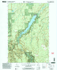
 1999 Vista Falls2004 Print · USGSThe Upper Peninsula wilderness comes into sharp focus during the late 1990s as it appeared within the Ottawa National Forest. Trace the winding path of the National Scenic Trail past Vista Falls and the steep terrain of the Sturgeon River Gorge Wilderness.
 - 1999 Map of Winona South, 2004 Print
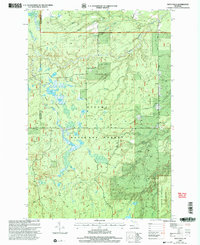
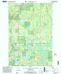
 1999 Winona South2004 Print · USGSUpper Peninsula copper country and timberlands meet in this late-twentieth-century study of the Ontonagon and Houghton county line. You can trace the remnants of local industry at the Mine Shaft and Tailings or locate family roots at the Woodland Cemetery and Winona.
 - 1999 Map of Kenton, 2004 Print
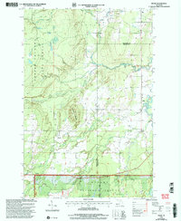
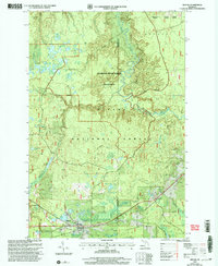
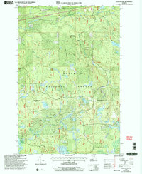
 1999 Kenton2004 Print · USGSThe Ottawa National Forest near the Houghton and Iron county borders is shown here as it transitioned into the twenty-first century. Genealogists and outdoor historians can trace the settlement at Kenton, the riverside Cem, and local landmarks like Jumbo Falls or Tepee Lake.
 - 1999 Map of Rousseau, 2004 Print
 1999 Rousseau2004 Print · USGSUpper Peninsula timberlands and small settlements are preserved here as they appeared just before the turn of the millennium. Genealogists and outdoor historians can trace old routes near Rousseau, the local Cem, and the recreation sites at Bob Lake.
 - 1999 Map of Marten Lake, 2004 Print
 1999 Marten Lake2004 Print · USGSThe northern Michigan wilderness at the close of the century is defined here by the dense lake-and-forest terrain of the Ottawa National Forest. Researchers can trace the winding Sidnaw Interpretive Trail or locate remote water bodies like Lake Sainte Kathryn and Hager Lake.
 - 1999 Map of Prickett Lake, 2004 Print
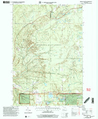
 1999 Prickett Lake2004 Print · USGSThe Houghton and Baraga county line runs through this remote section of the Upper Peninsula just before the millennium. Trace the path of the North Country National Scenic Trail past Prickett Dam and into the Sturgeon River Gorge Wilderness.
 - 1999 Map of Sidnaw, 2004 Print
 1999 Sidnaw2004 Print · USGSThe Upper Peninsula village of Sidnaw is shown at the close of the twentieth century, surrounded by the deep woods of the Ottawa National Forest. Researchers can locate the local Cem, the Prickett Grooms Landing Strip, and the remote Sturgeon River Gorge Wilderness.
 - 1999 Map of Glitter Lake, 2004 Print
 1999 Glitter Lake2004 Print · USGSThe border of Houghton and Iron counties was a densely forested wilderness of glacial lakes and wetlands at the close of the century. Genealogists and historians can trace family-named landmarks like Kitchi Cem, Beitner Lake, and Passmore Springs.
 - 1999 Map of Sparrow Rapids, 2004 Print
 1999 Sparrow Rapids2004 Print · USGSThe wilderness surrounding Kenton at the end of the millennium is meticulously mapped here, showing the intersection of forest management and local history. Researchers can locate the Camp Kenton CCC Camp Site, the Site of 1986 National Christmas Tree, and numerous creeks feeding the East Branch Ontonagon River.
End of results
Showing maps 1-11 of 11
Top cities of Houghton County
Frequently asked questions
- What are the different types of historical maps available for Houghton County?
- What is the oldest map of Houghton County?
- Where can I purchase historical maps of Houghton County for my home or office?
- Where can I download high-res historical maps of Houghton County?
- Are there historical topographic maps available for Houghton County?
- Is there historical aerial imagery available for Houghton County?
- Where are historical maps of Houghton County sourced from?