1950s Maps of Houghton County, Michigan
Explore 18 historic maps of Houghton County from the 1950s. These maps offer a rare glimpse into what life looked like during the 1950s — showing old roads, neighborhoods, homes, and landmarks that have changed or disappeared over time.
Whether you're researching your family's past, planning a metal detecting trip, or studying how Houghton County's landscape evolved across the 1950s, these high-resolution maps are a powerful tool for exploring the history of this region.
- Focus on a specific era: All maps on this page are from the 1950s, giving you a focused view of this time period.
- See what’s changed: Compare century-old streets, trails, and buildings to today's modern landscape using overlays and satellite layers.
- Research with precision: Use these maps for genealogy, historical research, land use analysis, or educational projects.
- View, download, or print: Maps are fully viewable online in high resolution, and can be downloaded or printed for your own records.
Start exploring Houghton County's history through authentic maps from the 1950s. This is your window into the past.
Houghton County, MI maps
(18)- 1954 Map of Traverse Island, 1955 Print
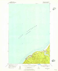
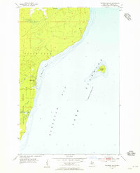 1954 Traverse Island1955 Print · USGSThe Keweenaw Peninsula’s eastern shore is captured in the mid-fifties, centered on the waters of Lake Superior. Researchers can trace the coastal settlement of Rabbit Bay and explore the wooded depths of Baraga State Forest near Traverse Island.3 unique versions available
 - 1954 Map of Gay, 1955 Print
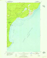 1954 Gay1955 Print · USGSCoastal Keweenaw County comes to life in the mid-fifties, showing the industrial interface between the copper mines and the Great Lakes. Trace the massive Tailings deposits at Gay and the transport path of the Copper Range along the shore.3 unique versions available
 - 1954 Map of Rice Lake, 1955 Print
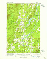
 1954 Rice Lake1955 Print · USGSThe Keweenaw Peninsula’s watery interior comes into focus in the mid-fifties, showing the rugged lake-and-creek systems of the northern Copper Country. You can trace the shoreline of Little Traverse Bay or locate the site of Minnetonka Camp near Rice Lake.4 unique versions available
 - 1954 Map of Graveraet River, 1955 Print
 1954 Graveraet River1955 Print · USGSThe Keweenaw Peninsula shoreline and the timbered hills of Houghton County are captured here in the mid-fifties. Genealogists and local historians can locate the Finnish Ch, Toivola Cem, and the Heikkinen Sch along the Copper Range rail corridor.3 unique versions available
 - 1954 Map of Oskar, 1955 Print
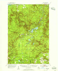
 1954 Oskar1955 Print · USGSThe Keweenaw Peninsula’s northern edge comes into focus during the mid-fifties, showing the maritime corridor of the Portage Lake Ship Canal. You can trace local roots at the Redridge Cem or locate old school sites like Onnela Sch.3 unique versions available
 - 1954 Map of Rousseau, 1956 Print
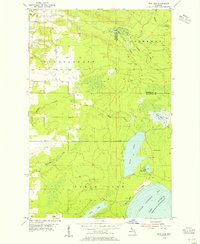
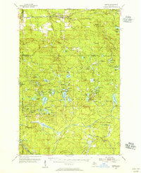
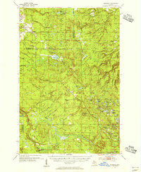 1954 Rousseau1956 Print · USGSHoughton and Ontonagon counties in the mid-1950s reveal a landscape defined by forestry and the reach of the rail lines. Researchers can trace the routes of the Chicago Milwaukee St Paul and Pacific Railroad and find sites like the Michigan College of Mining Forestry Camp and Rousseau.3 unique versions available
 - 1954 Map of Beacon Hill, 1956 Print
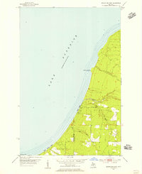
 1954 Beacon Hill1956 Print · USGSCoastal Houghton County comes into focus in the mid-fifties, showing the intersection of industrial rail and lakeside settlements. Trace the Copper Range tracks and explore the engineering of the Redridge Dam near Freda and Beacon Hill.3 unique versions available
 - 1954 Map of Rockhouse Point, 1956 Print
 1954 Rockhouse Point1956 Print · USGSThe Keweenaw Peninsula coastline remains largely wild in the mid-1950s, defined by the sweeping shores of Lake Superior. Researchers can trace the drainage of the Elm River and locate coastal landmarks like Stanton Park, Agate Beach, and Rockhouse Point.2 unique versions available
 - 1954 Map of Kenton, 1956 Print
 1954 Kenton1956 Print · USGSThe Upper Peninsula rail corridors and timberlands are well-defined in the mid-1950s, centering on the crossing of the Duluth South Shore and Atlantic. Researchers can locate historic sites like the Kenton Cemetery, Holmes Dam, and the old Lookout Tower.3 unique versions available
 - 1954 Map of Keweenaw Bay, 1956 Print
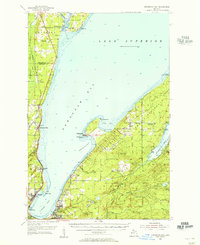 1954 Keweenaw Bay1956 Print · USGSThe Keweenaw Peninsula in the mid-fifties shows a shoreline defined by maritime trade and timber history. Researchers can trace the rail lines of the Chicago and North Western and locate landmarks like Pequaming, the Aura Sch (Abandoned), and the Indian Cem.3 unique versions available
 - 1954 Map of Point Mills, 1956 Print
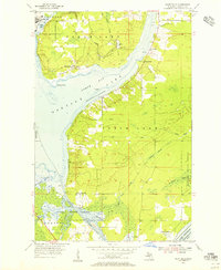 1954 Point Mills1956 Print · USGSThe Keweenaw Peninsula’s copper country is captured here in the mid-fifties, showing the vital rail and water networks of the era. Genealogists and historians can trace the foundations of local life through the Jacobsville Cem, Sarazin Sch, and the settlements at Dollar Bay and Lahti.3 unique versions available
 - 1954 Map of Perch Lake, 1956 Print
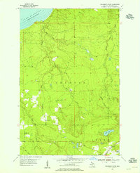
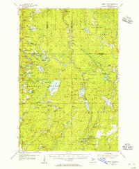 1954 Perch Lake1956 Print · USGSUpper Peninsula timberlands and glacial lakes are shown here during the mid-fifties at the meeting of Houghton, Baraga, and Iron Counties. Trace the Milwaukee Road rail line through Tunis or locate the Lookout Tower and Snake Rapids.3 unique versions available
 - 1954 Map of Pelkie, 1956 Print
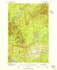
 1954 Pelkie1956 Print · USGSThe Baraga County backcountry and Finnish farming settlements of the mid-1950s are preserved here in striking detail. Researchers can trace family roots through sites like Elo Cem and Pelkie Cem or locate old community landmarks like Limestone Mountain.3 unique versions available
 - 1954 Map of Winona, 1956 Print
 1954 Winona1956 Print · USGSIn the mid-1950s, the Copper Country south of Houghton was a landscape of industrial mines and deep forests. Genealogists and historians can trace the foundations of Winona, locate the Winona Mine, and find rural landmarks like the Misery Bay Sch and Simar Landing Field.3 unique versions available
 - 1954 Map of Sidnaw, 1956 Print
 1954 Sidnaw1956 Print · USGSUpper Peninsula timber and rail country come to life in this mid-century survey of the Baraga County highlands. Researchers can trace the junction of two major railroads and locate local landmarks like the Covington Cem, Sturgeon Falls, and the Prickett Dam.2 unique versions available
 - 1954 Map of Houghton, 1959 Print
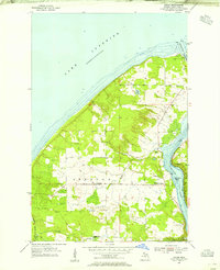
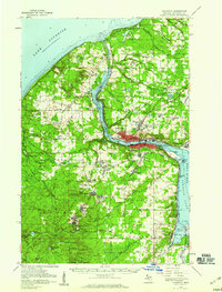 1954 Houghton1959 Print · USGSThe Keweenaw Peninsula copper mining district is shown here at mid-century, centering on the twin cities of Hancock and Houghton. Genealogists and industrial historians can trace the rail lines of the Duluth South Shore and Atlantic Railroad to legacy sites like Champion Mine, Mill Mine Junction, and Pewabic.2 unique versions available
 - 1958 Map of Hancock, 1967 Print
 1958 Hancock1967 Print · USGSThe Keweenaw Peninsula and Isle Royale are seen here during the mid-twentieth century as mining and maritime hubs. Trace the dense town layouts of Hancock and Calumet, or locate remote coastal markers like the Eagle Harbor Lighthouse and Rock of Ages Light.2 unique versions available
 - 1958 Map of Iron River, 1968 Print
 1958 Iron River1968 Print · USGSThe Upper Peninsula in the late fifties is captured here as a landscape of timber, iron, and rail. Genealogists and historians can trace rail stops like Mass Station or explore the coastlines of Lake Gogebic and Keweenaw Bay.3 unique versions available
End of results
Showing maps 1-18 of 18
Top cities of Houghton County
Frequently asked questions
- What are the different types of historical maps available for Houghton County?
- What is the oldest map of Houghton County?
- Where can I purchase historical maps of Houghton County for my home or office?
- Where can I download high-res historical maps of Houghton County?
- Are there historical topographic maps available for Houghton County?
- Is there historical aerial imagery available for Houghton County?
- Where are historical maps of Houghton County sourced from?