1800s (19th Century) Maps of Bates Township, Michigan
Explore 3 historic maps of Bates Township from the 1800s (19th Century). These maps offer a rare glimpse into what life looked like during the 1800s — showing old roads, neighborhoods, homes, and landmarks that have changed or disappeared over time.
Whether you're researching your family's past, planning a metal detecting trip, or studying how Bates Township's landscape evolved across the 1800s, these high-resolution maps are a powerful tool for exploring the history of this region.
- Focus on a specific era: All maps on this page are from the 1800s, giving you a focused view of this time period.
- See what’s changed: Compare century-old streets, trails, and buildings to today's modern landscape using overlays and satellite layers.
- Research with precision: Use these maps for genealogy, historical research, land use analysis, or educational projects.
- View, download, or print: Maps are fully viewable online in high resolution, and can be downloaded or printed for your own records.
Start exploring Bates Township's history through authentic maps from the 1800s. This is your window into the past.
Bates Township, MI maps
(3)- 1895 Map of Perch Lake
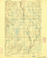 1895 Perch Lake1895 Print · USGSThe Upper Peninsula wilderness comes into focus in the mid-1890s as railroads began to pierce the deep woods of Iron and Baraga counties. Genealogists and historians can trace early rail routes like the D. S. S. and A. R. R. and remote waters such as Perch Lake and the Net River.3 unique versions available
 - 1898 Map of Iron River, 1899 Print
 1898 Iron River1899 Print · USGSUpper Peninsula mining and timber frontiers emerge in the 1890s as railroads begin connecting remote outposts. Researchers can trace early rail lines through Iron River and Stambaugh or locate former stations and camps at Hazle, Atkinson, and Saunders.2 unique versions available
 - 1899 Map of Crystal Falls
 1899 Crystal Falls1899 Print · USGSIron County mining and timber operations are at their peak at the close of the century. Genealogists and industrial historians can trace early rail spurs to the Mastodon Mine, Shafer Mine, and the developing town of Crystal Falls.2 unique versions available
End of results
Showing maps 1-3 of 3
Top cities near Bates Township
- Iron River historical maps
- Stambaugh historical maps
- Caspian historical maps
- Gaastra historical maps
- Alvin historical maps
Top neighborhoods of Bates Township
Frequently asked questions
- What are the different types of historical maps available for Bates Township?
- What is the oldest map of Bates Township?
- Where can I purchase historical maps of Bates Township for my home or office?
- Where can I download high-res historical maps of Bates Township?
- Are there historical topographic maps available for Bates Township?
- Is there historical aerial imagery available for Bates Township?
- Where are historical maps of Bates Township sourced from?