Old Maps of Mansfield, Mansfield Township for Academic Research
Study the evolution of Mansfield with 14 high-resolution historic maps. Whether you're teaching, researching, or modeling changes in land use, these maps provide essential visual documentation of urban, environmental, and geographic change.
- Analyze long-term change: Track patterns in development, transportation, and natural features.
- Ideal for environmental or urban studies: Support academic projects with primary historical map data.
- Use in the classroom or lab: Educators and researchers rely on these maps to bring historical context to life.
These maps are a powerful tool for teaching, research, and visualizing how Mansfield has changed over the decades.
Mansfield, Mansfield Township maps
(14)- 1899 Map of Sagola
 1899 Sagola1899 Print · USGSIron and Dickinson counties were defined by the expansion of the rail-and-river economy in the late nineteenth century. Genealogists and historians can trace the early layouts of Channing, Sagola, and Mansfield alongside the winding Michigamme River.3 unique versions available
 - 1947 Map of Lake Mary
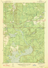 1947 Lake Mary1947 Print · USGSIron County, Michigan, is shown here shortly after the war, where the industrial legacy of the Northwoods meets its sprawling river system. Researchers can trace the Old Railroad Grade past Mansfield or locate School No 2 near the banks of the Michigan River.2 unique versions available
 - 1956 Map of Sagola, 1957 Print
 1956 Sagola1957 Print · USGSUpper Peninsula timber and rail history converge in the mid-fifties at the junction of the Chicago and North Western Railway. Trace the footprints of logging and mining settlements at Channing, Mansfield Location, and the McMillan Camp.
 - 1956 Map of Lake Mary, 1957 Print
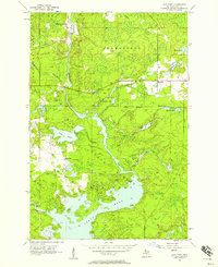 1956 Lake Mary1957 Print · USGSIron County's timber and river lands are captured here in the mid-fifties, just as the region's industrial footprint was evolving. Genealogists and historians can trace the Railroad Grade near Mansfield and locate the historic Mansfield Location.3 unique versions available
 - 1958 Map of Iron River, 1968 Print
 1958 Iron River1968 Print · USGSThe Upper Peninsula in the late fifties is captured here as a landscape of timber, iron, and rail. Genealogists and historians can trace rail stops like Mass Station or explore the coastlines of Lake Gogebic and Keweenaw Bay.3 unique versions available
 - 1960 Map of Iron River
 1960 Iron River1960 Print · USGSThe Upper Peninsula’s western reaches are shown in the late fifties, featuring the industrial infrastructure of the Copper Country and the vast Ottawa National Forest. Researchers can trace the rail lines of the Milwaukee Road through settlements like Bruce Crossing and the White Pine Mine.
 - 1961 Map of Iron River
 1961 Iron River1961 Print · USGSThe Upper Peninsula and northern Wisconsin are shown here in the early 1960s, a landscape defined by the iron range and vast timberlands. Researchers can trace the legacy of mining and rail transport through Caspian, the Lac Du Flambeau Indian Reservation, and the Milwaukee Road.
 - 1967 Map of Iron River, 1968 Print
 1967 Iron River1968 Print · USGSThe Upper Peninsula and northern Wisconsin borderlands are shown here in the late sixties, a landscape of deep woods and iron-country rail lines. Genealogists and historians can trace the lakeside settlements of L'Anse and Ontonagon or follow the Soo Line through towns like Michigamme and Nestoria.
 - 1989 Map of Iron River, 1990 Print
 1989 Iron River1990 Print · USGSUpper Peninsula mining and timber lands are documented here in the late 1980s, showcasing the region's industrial and natural interface. Researchers can trace the iron heritage through the Monongahela Mine and local junctions like Kelso Junction and Amasa.
 - 2011 Map of Lake Mary, 2011 Print
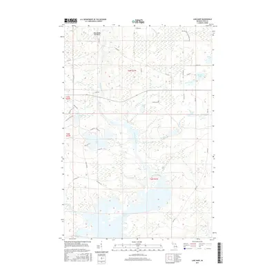
 2011 Lake Mary2011 Print · USGSCovers Mansfield, including Mansfield Township, Mastodon Township, and other nearby areas
 - 2014 Map of Lake Mary, 2014 Print
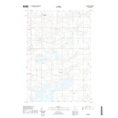
 2014 Lake Mary2014 Print · USGSCovers Mansfield, including Mansfield Township, Mastodon Township, and other nearby areas
 - 2017 Map of Lake Mary, 2017 Print
 2017 Lake Mary2017 Print · USGSCovers Mansfield, including Mansfield Township, Mastodon Township, and other nearby areas
 - 2019 Map of Lake Mary, 2019 Print
 2019 Lake Mary2019 Print · USGSCovers Mansfield, including Mansfield Township, Mastodon Township, and other nearby areas
 - 2023 Map of Lake Mary, 2023 Print
 2023 Lake Mary2023 Print · USGSIron County’s Upper Peninsula wilderness is documented here in the early twenty-first century, centered on the flow of the Michigamme River. You can trace the historic Mansfield Location or explore the vast shorelines of Peavy Pond and Lake Mary.
End of results
Showing maps 1-14 of 14
Top cities near Mansfield
- Crystal Falls historical maps
- Sagola historical maps
- Mastodon historical maps
- Florence historical maps
- Commonwealth historical maps
- Mansfield historical maps
See more
Frequently asked questions
- What are the different types of historical maps available for Mansfield?
- What is the oldest map of Mansfield?
- Where can I purchase historical maps of Mansfield for my home or office?
- Where can I download high-res historical maps of Mansfield?
- Are there historical topographic maps available for Mansfield?
- Is there historical aerial imagery available for Mansfield?
- Where are historical maps of Mansfield sourced from?