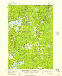
1956 Map of Sagola
USGS Topo · Published 1957About this map
The timber and rail corridors of the Upper Peninsula define this mid-century landscape, centered on the intersection of the Chicago Milwaukee St Paul and Pacific Railroad and the Chicago and North Western Railway. The small community of Channing serves as a central hub, flanked by the Channing Cem and the nearby operations of Sagola and Kiernan. The terrain is characterized by extensive forest management areas including the Michigamme State Forest and the Sturgeon River State Forest, where early industrial footprints like the Mansfield Location and McMillan Camp sit alongside large-scale water features like the Michiganamme Reservoir. Hydrological control is evident at Way Dam and the Hemlock Falls Dam Spillway, while the Silver Lake Lookout Tower and Michigamme Mtn provide the primary elevation markers across these wooded Iron Range townships.
Find a feature on this map
77 named features on this map. Tap any name to fly to it.
Don’t see what you’re looking for? This feature index may not catch every label — zoom into the map to look around manually.
Map Details
Editions of this 1956 Sagola Map
This is the sole edition of this map. No revisions or reprints were ever made.
Other maps of this area

1895 · Ned Lake
USGS Topo · 1:62,500

1899 · Sagola
USGS Topo · 1:62,500

1899 · Witbeck
USGS Topo · 1:62,500

1899 · Crystal Falls
USGS Topo · 1:62,500

1939 · Iron Mountain
USGS Topo · 1:48,000

1941 · Florence
USGS Topo · 1:48,000

1941 · Iron Mountain
USGS Topo · 1:48,000

1944 · Crystal Falls
USGS Topo · 1:24,000

1945 · Kelso Junction
USGS Topo · 1:24,000

1946 · Crystal Falls
USGS Topo · 1:31,680