
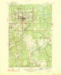
1946 Map of Crystal Falls
USGS Topo · Published 1946About this map
Iron mining and timber transport define the landscape around Crystal Falls in the mid-1940s. The town serves as a hub for the Menominee Range, where specialized settlements known as "locations"—including Western Location, Odgers Location, and Tobin Location—huddle near the industrial workings of the Shafer Mine and Tobin Mine. This pattern of settlement reflects the era's reliance on proximity to the pits, with the Chicago and Northwestern and the Milwaukee St Paul and Pacific railroads threading through the hills to carry ore and lumber.
Find a feature on this map
46 named features on this map. Tap any name to fly to it.
Don’t see what you’re looking for? This feature index may not catch every label — zoom into the map to look around manually.
Map Details
Editions of this 1946 Crystal Falls Map
2 editions found
Other maps of this area

1899 · Sagola
USGS Topo · 1:62,500

1899 · Crystal Falls
USGS Topo · 1:62,500

1939 · Iron Mountain
USGS Topo · 1:48,000

1941 · Florence
USGS Topo · 1:48,000

1941 · Iron Mountain
USGS Topo · 1:48,000

1944 · Crystal Falls
USGS Topo · 1:24,000

1944 · Fortune Lakes
USGS Topo · 1:24,000

1945 · Kelso Junction
USGS Topo · 1:24,000

1945 · Amasa
USGS Topo · 1:24,000

1946 · Fortune Lakes
USGS Topo · 1:31,680