1970s Maps of Isabella County, Michigan
Explore 10 historic maps of Isabella County from the 1970s. These maps offer a rare glimpse into what life looked like during the 1970s — showing old roads, neighborhoods, homes, and landmarks that have changed or disappeared over time.
Whether you're researching your family's past, planning a metal detecting trip, or studying how Isabella County's landscape evolved across the 1970s, these high-resolution maps are a powerful tool for exploring the history of this region.
- Focus on a specific era: All maps on this page are from the 1970s, giving you a focused view of this time period.
- See what’s changed: Compare century-old streets, trails, and buildings to today's modern landscape using overlays and satellite layers.
- Research with precision: Use these maps for genealogy, historical research, land use analysis, or educational projects.
- View, download, or print: Maps are fully viewable online in high resolution, and can be downloaded or printed for your own records.
Start exploring Isabella County's history through authentic maps from the 1970s. This is your window into the past.
Isabella County, MI maps
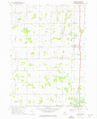
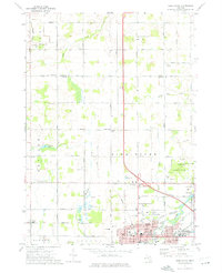
(10)- 1973 Map of Winn, 1975 Print
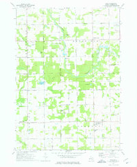 1973 Winn1975 Print · USGSIsabella County in the early seventies shows a landscape of steady rural life and river-valley geography. Genealogists and local historians can locate family landmarks like Union Cem, the Covered Bridge on the Chippewa, and the Isabella Indian Reservation Boundary.
 - 1973 Map of Shepherd, 1976 Print
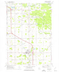 1973 Shepherd1976 Print · USGSShepherd and the surrounding Isabella County townships are seen here in the early seventies, caught between agricultural tradition and local industrial expansion. Researchers can trace historic church sites like Indian Ch and family burial plots at Salt River Cem or Township Cem.
 - 1973 Map of Mount Pleasant, 1976 Print
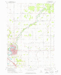
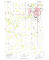 1973 Mount Pleasant1976 Print · USGSMount Pleasant and its surrounding townships are shown here in the early 1970s, just as the university campus and residential suburbs were expanding. Genealogists and local historians can trace the Indian Reservation Boundary or locate family plots in Calvary Cem and Lincoln Cem.
 - 1973 Map of Weidman, 1976 Print
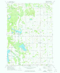 1973 Weidman1976 Print · USGSIsabella County in the early seventies shows a landscape of growing lake communities and rural townships. Researchers can locate family roots at St Joseph Cem or trace the early development of Weidman and Lake Isabella.
 - 1973 Map of Rosebush, 1976 Print
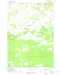
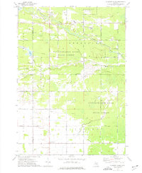
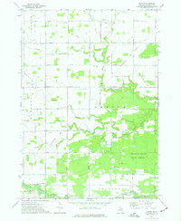
 1973 Rosebush1976 Print · USGSIsabella County during the early seventies is shown here as a landscape of grid-patterned township roads and scattered oil production. Genealogists can trace family footprints at St Henrys Ch, Indian Cem, and the small settlement of Schofield.
 - 1973 Map of Alma North, 1976 Print
 1973 Alma North1976 Print · USGSGratiot County's agricultural and academic heart comes into focus in the early 1970s as Alma and St Louis continue their growth along the Pine River. Genealogists and local historians can locate long-standing rural landmarks like Brady Cem, St Johns Ch, and the outlying village of Elwell.
 - 1973 Map of Alamando, 1976 Print
 1973 Alamando1976 Print · USGSMidland and Isabella County at the start of the 1970s show a landscape shaped by state forests and the winding Salt River. Genealogists can locate family landmarks like the Township Cem, Geneva Hope Ch, and the rural community of Alamando.
 - 1973 Map of Pleasant Valley, 1976 Print
 1973 Pleasant Valley1976 Print · USGSMidland and Isabella counties in the early 1970s reveal an active landscape of energy production and rural community life. Trace the development of Oil City and family landmarks like Kelly Cem or the Martin Luther Institute.
 - 1973 Map of St. Louis, 1977 Print
 1973 St. Louis1977 Print · USGSMid-century St. Louis and the surrounding farm country are captured here during a period of steady industrial and civic activity. Genealogists and local historians can trace family locations near the Bethany Indian Cem, Oak Grove Cemetery, or the numerous local schools like Westgate Sch.
 - 1973 Map of Leaton, 1977 Print
 1973 Leaton1977 Print · USGSIsabella County in the early seventies was a hub of energy production and timber management as the oil fields expanded. Genealogists and historians can trace family roots through the Bissing Cem or locate old wells in the Rosebush Oil Field and Vernon Oil Field.
End of results
Showing maps 1-10 of 10
Top cities of Isabella County
Frequently asked questions
- What are the different types of historical maps available for Isabella County?
- What is the oldest map of Isabella County?
- Where can I purchase historical maps of Isabella County for my home or office?
- Where can I download high-res historical maps of Isabella County?
- Are there historical topographic maps available for Isabella County?
- Is there historical aerial imagery available for Isabella County?
- Where are historical maps of Isabella County sourced from?