1970s Maps of Jackson, Michigan
Explore 4 historic maps of Jackson from the 1970s. These maps offer a rare glimpse into what life looked like during the 1970s — showing old roads, neighborhoods, homes, and landmarks that have changed or disappeared over time.
Whether you're researching your family's past, planning a metal detecting trip, or studying how Jackson's landscape evolved across the 1970s, these high-resolution maps are a powerful tool for exploring the history of this region.
- Focus on a specific era: All maps on this page are from the 1970s, giving you a focused view of this time period.
- See what’s changed: Compare century-old streets, trails, and buildings to today's modern landscape using overlays and satellite layers.
- Research with precision: Use these maps for genealogy, historical research, land use analysis, or educational projects.
- View, download, or print: Maps are fully viewable online in high resolution, and can be downloaded or printed for your own records.
Start exploring Jackson's history through authentic maps from the 1970s. This is your window into the past.
Jackson, MI maps
(4)- 1970 Map of Gilletts Lake, 1973 Print
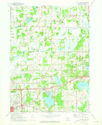 1970 Gilletts Lake1973 Print · USGSJackson County's landscape east of the city is captured here in the early 1970s, showing a blend of institutional land and growing lakeside communities. Trace historic footprints at the State Prison Farm, Henrietta Station, and old family burial grounds like Coon Hill Cem.2 unique versions available
 - 1970 Map of Jackson North, 1973 Print
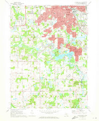
 1970 Jackson North1973 Print · USGSJackson and its northern townships are shown in the early seventies as the city’s residential grid met the industrial rail lines. Genealogists can trace family sites like Draper Cem and Jones Cem or locate old schoolhouses like Parnall Sch.2 unique versions available
 - 1971 Map of Jackson South, 1973 Print
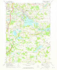
 1971 Jackson South1973 Print · USGSJackson and its southern suburbs were expanding during the early 1970s as new campus facilities and parks reshaped the landscape. Researchers can trace local heritage at St Johns Cemetery, Jackson Community College, and the old rail corridor of the Penn Central.3 unique versions available
 - 1971 Map of Michigan Center, 1973 Print
 1971 Michigan Center1973 Print · USGSJackson County’s lake country is captured here in the early seventies, showing the residential expansion around Michigan Center and Leoni. Genealogists and researchers can locate family sites near Roseland Memorial Gardens Cemetery, Ackerson Lake Sch, and the Penn Central rail corridor.
End of results
Showing maps 1-4 of 4
Top cities near Jackson
- Leoni historical maps
- Spring Arbor Township historical maps
- Napoleon historical maps
- Vandercook Lake historical maps
- Somerset historical maps
- Onondaga historical maps
See more
Frequently asked questions
- What are the different types of historical maps available for Jackson?
- What is the oldest map of Jackson?
- Where can I purchase historical maps of Jackson for my home or office?
- Where can I download high-res historical maps of Jackson?
- Are there historical topographic maps available for Jackson?
- Is there historical aerial imagery available for Jackson?
- Where are historical maps of Jackson sourced from?