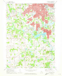
1971 Map of Jackson South
USGS Topo · Published 1973About this map
Jackson spreads its urban footprint across the northern half of this survey, anchored by municipal landmarks like City Hall and the Post Office. The southern landscape is defined by its recreation and residential growth, featuring the expansive Sparks Foundation County Park with its distinctive Ski Lift and the neighboring Sharp Park. Local education is well-represented by Jackson Community College and several parochial institutions such as Christi High Sch and St Johns Sch.
Find a feature on this map
131 named features on this map. Tap any name to fly to it.
Don’t see what you’re looking for? This feature index may not catch every label — zoom into the map to look around manually.
Map Details
Editions of this 1971 Jackson South Map
3 editions found
Other maps of this area

1919 · Springport
USGS Topo · 1:62,500

1919 · Rives Junction
USGS Topo · 1:62,500

1921 · Rives Junction
USGS Topo · 1:62,500

1921 · Springport
USGS Topo · 1:62,500

1935 · Jackson
USGS Topo · 1:48,000

1939 · Jackson
USGS Topo · 1:62,500

1948 · Spring Arbor
USGS Topo · 1:62,500

1949 · Spring Arbor
USGS Topo · 1:62,500

1958 · Grand Rapids
USGS Topo · 1:250,000

1961 · Grand Rapids
USGS Topo · 1:250,000